

 Positioning technologies for outdoor location-based services are pretty straight forward. Cell-ID, WiFI, GPS. But this is not that easy when it comes to finding your way indoors. Although the topic has been around for a while and every university and larger tech-company is working on it there are no common standards yet. Google has been using WiFi. Apple focused on Bluetooth 4.0. Nokia together with In-location Alliance has been developing some kind of hybrid solution. And many other companies are proposing different kinds solutions mostly based on proximity or triangulation.
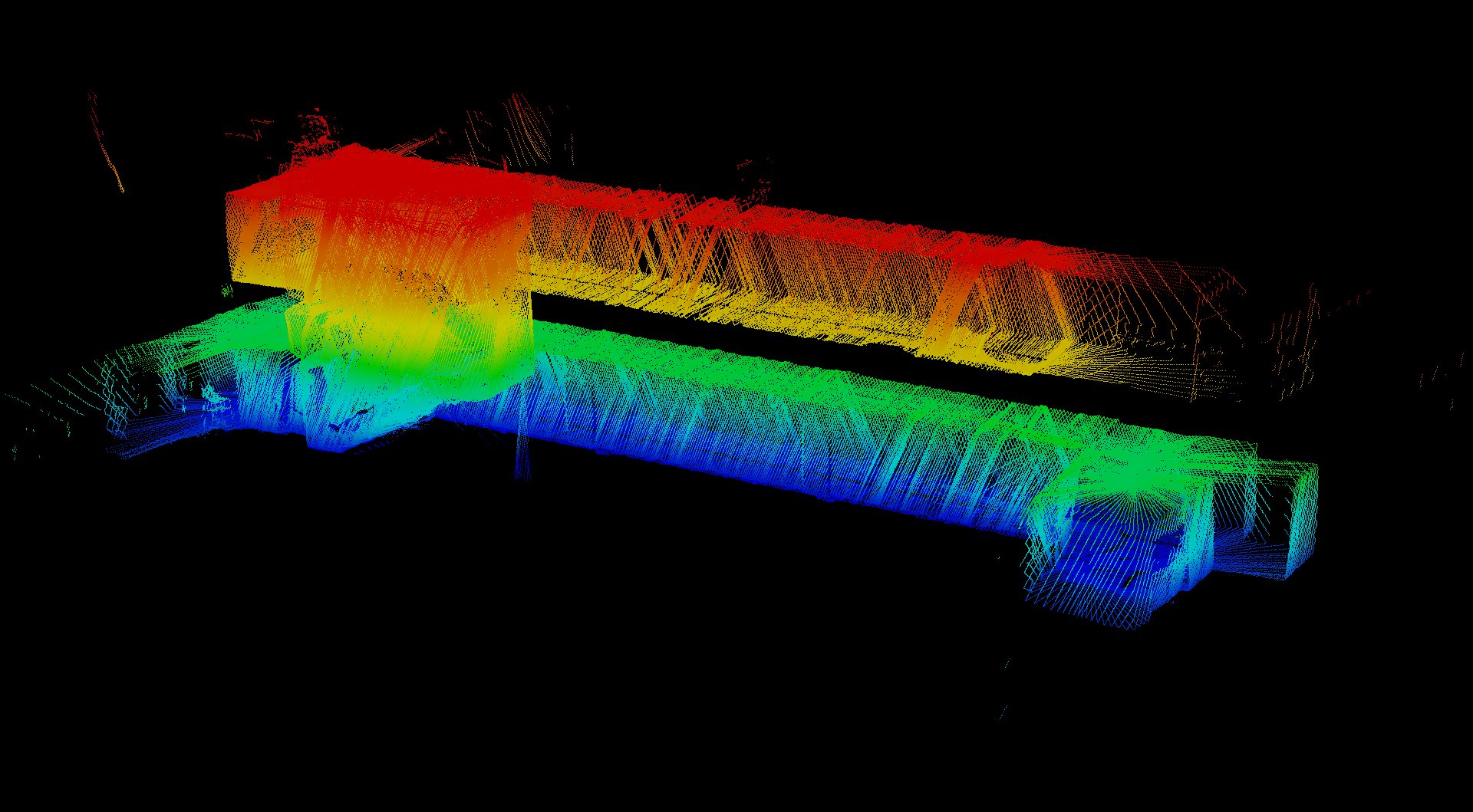
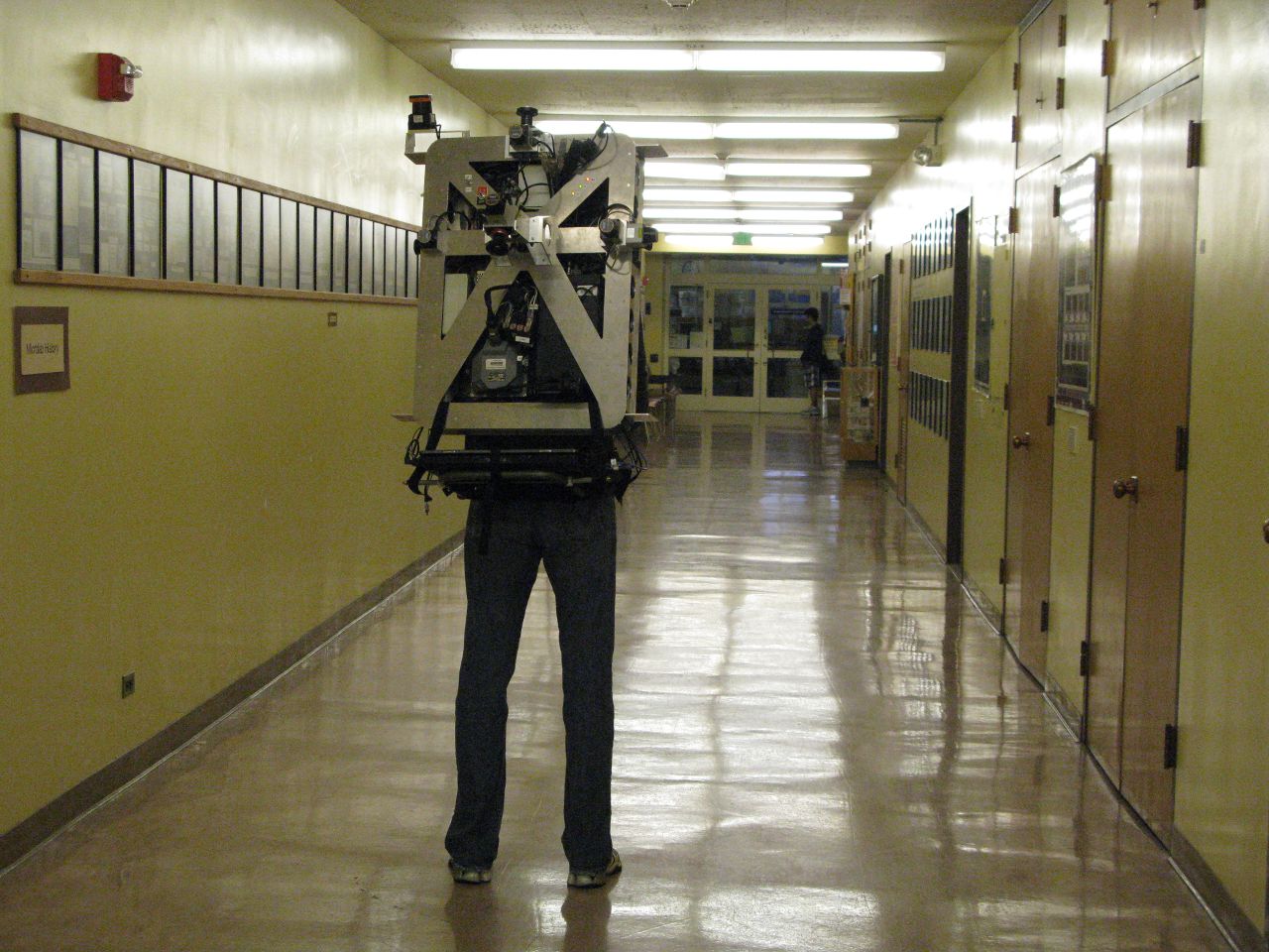 But it seems that there is another possibility… Researchers at the University California, Berkeley has developed a new method which uses a photo from a device’s camera to find the location and orientation of the device. The matching of the photo is performed against a database of panoramic imagery of a building’s interior, similar to Google’s Street View. So in fact the device recognizes the image in a database and the image has known location due to the capturing technology. The researchers are using technology similar to Google’s Trekker backpack to capture panoramic images and create a model of the building. Researchers says that during tests at the mall, they successfully matched more than 96 percent of images taken by a smartphone camera. When the matches were turned into location fixes, most came out with an error of less than a meter from the device’s true location.
![]() This method is clearly designed for solutions like Google Glass which lacks of GPS and WiFi sensors but it could be also used for augmented reality and indoor image geo-tagging for example by Facebook. The researchers claim that big advantage of the method is that it doesn’t require changing the environment in any way (placing Bluetooth iBeacons of WiFi routers). But from the other hand it requires the location to be Street Viewed which might be actually more expensive than setting up a few Bluetooth sensors. One thing is sure… The fact that recently Google started to capture indoor Street View suggests that the technology will find its way to mobile devices sooner than later.
This method is clearly designed for solutions like Google Glass which lacks of GPS and WiFi sensors but it could be also used for augmented reality and indoor image geo-tagging for example by Facebook. The researchers claim that big advantage of the method is that it doesn’t require changing the environment in any way (placing Bluetooth iBeacons of WiFi routers). But from the other hand it requires the location to be Street Viewed which might be actually more expensive than setting up a few Bluetooth sensors. One thing is sure… The fact that recently Google started to capture indoor Street View suggests that the technology will find its way to mobile devices sooner than later.

#Business


Next article

 What does Coral Reefs, the ancient ruins in Mongolia, the awesome view of Earth from Space and the old temples in Japan have in common? Well, if any one of these was on your bucket list then you could now experience all of these without even leaving your easy-chair.
Let’s face it, making a bucket list is the easier part of the deal and in any case the bucket list is only getting longer and longer which makes it all the more difficult to accomplish everything. How about a compromise without taking it off the list?
Ever heard of the term “Arm Chair Tourism?”. Here’s some geoawesome projects that let you be the awesome armchair tourist!
Here’s a project by an organisation called Underwater Earth, they literally took Google Maps underwater!! Yup! This is what made me write the entire article on ArmChair Geography and Iyke wrote the article on “Underwater Maps” that I wanted to, just 438 days earlier!! Here’s the link to this amazing project – Google Maps For Ocean
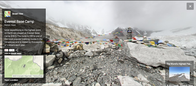
Well as you can expect with Google, they just didnt stop there. They ended up mapping UNESCO sites, Landmarks in Europe, the Highest Base Camp in the world and even Antarctica .
Now that’s what I call, taking Geography to heights! Speaking of heights, here’s a really cool video from the European Space Agency on view of earth from space!
If you are wondering if all of this is just for fun! think again! There have many cases of people finding shipwrecks, even new islands using “Armchair Geography”. Here’s an article on TelegraphPost. Well sometimes even Google Maps can create a lot of confusion, remember the story of the island that did not exist on earth but on google maps?
I for sure didn’t know that you could “see” so much without leaving your easy-chair! Armchair tourism! Armchair Geography! Geoawesome indeed 🙂