
“India Launches its maiden mission to Mars”: Google “Mars” today and chances are that you’ll end up reading about India’s Mars Mission!
The “Mars Orbiter Mission” has successfully been placed in its orbit around the earth which is the first stage in it’s 300 day trip to the red planet.
There has been so much of media following all round the world that I doubt that you haven’t already heard or read about it. Some of the articles have been really negative even going to the extent of questioning the necessity of such a mission by a country that continues to battle poverty. But first let’s talk science 😉
Orbital Information:
The satellite will now orbit around the earth for another 30 days; slowly increasingly the eccentricity of the orbit where it will finally be able to leave the Earth’s gravity field and continue its onward journey to the Mars mission. The Indian Space Research Organization (ISRO) has already created a niche for itself with their low-cost and effective missions notably the Moon Mission in 2008. The Current Mars Mission has been launched at a cost of 72$ Million. In comparison, the NASA mission to mars which is slated to be launched in the following weeks has a price tag of over 600 $ Million. Although a lot of articles have been written already about the cost, it is worth noting that the mission objectives and equipment are slightly different. Complete information regarding India’s Mars Orbiter and its equipment can be found here – ISRO’s Link.
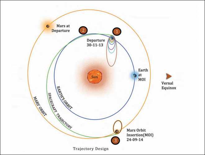
Mars Orbiter Mission – Orbital Information
Only United States of America, Russia and the European Space Agency have so far been able to successfully place a satellite in the mars orbit. Whether India will make it to the illustrious list is something that we can expect to know by September 2014. Nevertheless this mission is going to help the ISRO design more inter-planetary space missions in the future and hopefully the Indian example of low-cost space missions is going to help drive the costs down around the world, thereby taking the heat off the “waste of tax money” debate.
It’s a historic mission and if ISRO succeeds, it is definitely going to make history as the first Space Agency to succeed in the Mars mission in the first attempt! Here’s a really good video regarding the mission, a bit too long though.
Regarding some of the negative comments that have been going around regarding the necessity and importance of such a mission by India whose poverty record is really nothing to showcase. Well India is known for its contrasts and it is true that space exploration and poverty co-exist. But the cost-effective missions can really help push the commercial space industry towards India thereby helping eradicate poverty. What’s your take on the Mars Mission?
Congratulations ISRO! Hopefully the Mars Orbiter will actually orbit the Mars in September 2014. We’ll keep you updated regarding the mission!


#

Next article

Did you ever hear about GOES-R? If you didn’t, continue and broaden your mind! GOES-R is the next generation of geostationary weather satellites in US – the connotation: Geostationary Operational Environmental Satellite-R Series – and is scheduled to launch in early 2016. As we all know the characteristic to remain stably over a point of the earth’s surface makes geostationary satellites highly useful for observing environmental conditions such a weather, atmosphere and fires on the one hand, the other broad span of application is for telecommunications. GOES-R is the successor of GOES-14 and is a cooperation between NOAA and NASA. While NOAA is going to manage the program, an integrated NOAA-NASA office organisation with personnel coming from both is co-located at NASA’s Goddard Space Flight Center in Greenbelt, Maryland. The GOES-R series is going to continue the 2-satellite system, with operating satellites at 75W and 137W. The main purpose is to continue the observation of weather and atmospheric occurrences with enhanced instruments that will permit improved hurricane track and intensity forecast, real-time mapping of lightning and thus an increased performance in thunderstorm and tornado warning, improved geomagnetic storm forecasting which is important for GNSS and finally improved monitoring of solar features. See a detailed list of the most important sensors in the following section.
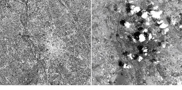
GOES-14 image of April tornados in 2011, USA.
Technical improvements
The GOES-R program will mark the first major technological advances in geostationary observations since 1994. Compared to the current GOES program a couple of new instruments and data processing methods will provide a better quality of observation:
Advanced Baseline Imager (ABI):
- Four times greater ground resolution
- Five times faster coverage
- Three times more spectral bands (16 bands including 2 visible, 4 near infrared and 10 infrared channels, the number of bands will enable to observe nI and I without degrading influence of cloud cover)
- Higher coverage simultaneously
Geostationary Lightning Mapper (GLM):
- Real time mapping of lightning activity over land and water
The monitoring of solar features is of great importance for aviation flights, spaceflight and astronauts in terms of security. The new sensors on GEOS-R will be:
Solar Ultra Violet Imager (SUVI):
SUVI will observe the sun in the extreme ultra violet wavelength and will provide full-disk solar images with approximately 5 arcsec spatial resolution at 10 second imaging cadence. SUVI will observe and characterize complex active regions of the sun, solar flares, and the eruptions of solar filaments which may give rise to coronal mass ejections. The main goals of SUVI are:
- Locate coronal holes for geometric storm forecasts
- Detect and locate flares for forecasts of solar energetic particle events related to flares
- Monitor changes in the corona that indicate Coronal Mass Ejections (CMEs)
- Detect active regions beyond the east limb for activity forecasts
- Analyze active region complexity for flare forecasts
EUV and X-Ray Irradiance Sensors (EXIS):
EXIS detects solar X-ray and solar extreme ultraviolet irradiance in the 5-127 nm range. It will monitor:
- Solar flares that can disrupt communications and degrade navigational accuracy affecting satellites, astronauts, high latitude airline passengers, and power grid performance.
- Solar variations that directly affect satellite drag/tracking and ionospheric changes, which impact communications and navigation operations.
Space Environment In-Situ Suite (SEISS):
SEISS will monitor the proton, electron, and heavy ion fluxes at geosynchronous orbit, which is e.g. critical for estimating the radiation that is hazard to astronauts and satellites. For earth relevant purposes SEISS will warn of high flux events, mitigating any damage to radio communication.
Magnetometer (MAG):
The GOES-R Magnetometer will provide measurements of the space environment magnetic field that controls charged particle dynamics in the outer region of the magnetosphere. These particles can be dangerous to spacecraft and human spaceflight.
Improved instruments also require an enhanced data transmission. The GOES-R Unique Payload Service (UPS) will permit high rate information transmission that is necessary to deliver actual information to immediately to where it is needed.
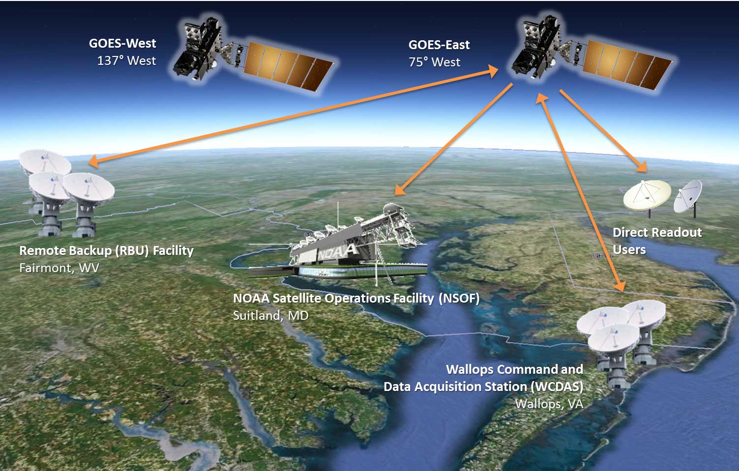
The operation architecture of the new GOES-R series. Scheme GOES-R mission.
GOES-R mission: Video
The importance of historic data and some thoughts about meteorology
In Europe meteorological data have been recorded since the 18th century, at this time mainly by royal institutions. In Austria, for instance, the ZAMG (Central Institution for Meteorology and Geodynamics/ Zentralanstalt für Meteorologie und Geodynamik) was founded in 1851 for observing climate by recording meteorological parameters. Already in 1873 the first international meteorological congress took place in Vienna with delegates coming from 16 different countries (Belgium, China, Denmark, Germany, UK, Ireland, Italy, The Netherlands, Norway, Austrian-Hungarian Monarchy, Portugal, Russia, Sweden, Switzerland, Spain and Turkey). At this date the International Meteorological Organisation (IMO), ancestor of the WMO, was founded with the purpose of exchanging meteorological information. I’d say, that meteorology has a long tradition and since that time, different weather features were permanently recorded. This proofes to be highly beneficial for topics as climate change when today we are able to compare those data with the most recent ones and to create climate time series. The new epoch of earth observation allows monitoring far more parameters than only meteorological ones. Like the meteorological time series from the last two centuries those new data will constitute a precious source of information in future. Let’s keep that in mind!