

Government gazettes don’t typically make for riveting reads. The documents run into dozens and dozens of pages, you need to navigate through a ton of jargon and legalese, and there’s a lot of going back and forth involved – because the penalty for ‘contravention of sub-rule (1) of rule 23’ would suddenly manifest 20 pages later without a link back to the original rule.
Government gazettes rarely make for riveting reads, except when they come in the form of a notification from India’s Ministry of Civil Aviation, detailing the 2021 rules for the drone industry. Because here, clause after clause is designed to make your jaw drop. The more you read, the more you are gripped – by the sheer implausibility of it all.
Related: Thinking of importing or manufacturing drones in India? Read this first
The rules came into force the same day they were published in the Official Gazette – March 12, 2021. And just as simply as Thanos could set off mass extinction with a snap of his fingers, these rules deemed the entire drone industry in India illegal.
To be fair, much of the operations were being done furtively before March 12 also – chiefly because the government’s online platform designed to grant flight permissions and ensure the smooth functioning of all drone-related activities has been perpetually under construction. Only now, the unlawfulness of drone operations will attract much more severe penalties – not just for the owners, operators (commercial and recreational alike), service providers but also for the manufacturers, importers, and traders.
As per the Unmanned Aircraft System Rules, 2021, every stakeholder of the industry needs to procure an official certificate of ‘authorization’ from the Directorate General of Civil Aviation (DGCA) to continue doing what they may have been doing for years now – right from manufacturing the simplest of drone components, such as a wire or a screw, to conducting research and development of an unmanned aircraft system. And this is just the first step. The new rules are deliriously high on the licensing system.
Once you have received your ‘authorization’ certificate, you need to submit a separate application to the DGCA to obtain permission for the manufacture or import of a prototype drone (for a fee, of course. There’s a fee to be paid with every application). Each prototype drone that you create or import will be assigned a unique identification number by the DGCA. Hold on to these UINs, because their transfer from one stakeholder to another will also entail a time-consuming paper trail and fee at each step.
Now, to obtain a certificate of manufacture and airworthiness, you send another application to the DGCA, post which you handover your prototype drone and all the design documents to an ‘authorized’ testing laboratory chosen by the Director-General.
And then, you wait. Maybe for weeks, maybe for months. The rules don’t specify any timeline or tracking mechanism for the progress of any of these applications.
What they do specify is that if you need to import a spare part for a drone for which a certificate of manufacture and airworthiness has already been granted to you, you still need to take prior approval of the DGCA by filling out yet another application form. And no, it doesn’t help that the Directorate General of Foreign Trade has already issued you an Importer-Exporter Code (IEC) number.
By now, you should have understood that a passion for seeking approvals is a skill you must be able to highlight on your resumé if you are to survive in the Indian drone industry. So, before each test flight, you take prior clearance from the local authority and the Air Traffic Control – even when these test flights are to be conducted under the direct supervision of an appropriately licensed remote pilot at a predesignated site notified by the Central Government.
Also read: Flying a drone in India? See what 2021 drone rules say for pilots
That said, chances are, you may never reach the test flight stage. It would take nothing short of a miracle for you to find ‘authorized’ manufacturers for all the components the DGCA says your drone must have before it makes its way to a testing laboratory.
And by the time you check off the boxes on the list of the technical requirements, your drone would have become economically unfeasible for today’s markets.
A 360-degree collision avoidance system, for example, has been mandated for a Micro category drone (weighing ≤ 2 kg) that would be flown by a trained, ‘authorized’ operator within the visual line of sight. And an emergency recovery system is absolutely essential for a Small category (weighing ≤ 25 kg) agricultural spraying drone that has been designed to fly only 2 meters above the ground level.
Even toy drones (weighing less than 250 gm) are to be outfitted with Global Navigation Satellite System (GNSS) receivers and have high-tech features like geofencing capabilities and autonomous ‘Return to Home’ options.
For a hobbyist, however, the higher price point for a beginner drone will not be the only barrier to entry. To fly any drone weighing more than 250 gm for recreational purposes, you are required to undergo a week-long training program costing upward of INR 25,000. Two separate pilot permit applications need to be submitted to the DGCA – first as a student and then, after the completion of the training, as an operator. Two other applications must be submitted to get both the drone and the drone owner registered with the authorities.
And even after all this, you cannot just wake up one morning in a hotel and decide to capture your vacation moments from the air. Here also, you need to take prior permission from the DGCA, defining clearly the area where you want to fly. And how do you take this permission? Through the same defunct online portal, of course!
Interestingly, India is part of Joint Authorities for Rulemaking of Unmanned Systems (JARUS), a group of experts from National Aviation Authorities (NAAs) of five continents, EUROCONTROL, and the European Aviation Safety Agency (EASA). In 2019, JARUS published a document – debated and developed over a period of 4 years – to recommend the level of regulatory involvement for various types of drones and drone operations.
This document suggested that based on the unmitigated risk associated with UAS operations, every drone and drone operation should be characterized by one of the following three categories:
Category A (Open)
In this category, JARUS recommends self-certification. Adoption of industry standards may apply but airworthiness requirements should not be made mandatory. Risk mitigation should be applied through the adoption of operational limitations, such as no-fly zones and visual line of sight operations, without requiring approvals issued by an aviation regulator. The operator should be deemed responsible for safe operations.
Examples of operations falling in this category include toy/Nano drones as well as recreational, hobbyist drones of the Micro category. This category could also include commercial drone operations that present a low unmitigated risk, such as low airspace survey of critical infrastructure located far away from human habitation.
Category B (Specific)
As the operations go beyond the limitations of Category A, an acceptable level of risk is ensured by a risk assessment of the operation and identification of mitigation steps. This could include requirements addressing the design of the drone, operational limitations, and qualifications of the drone pilot. Varying levels of oversight are recommended for this category.
Category C (Certified)
This is the category that should have full regulatory oversight because the high levels of risks here cannot be solely mitigated through operational limitations. As such, risk mitigation here would involve a type design approval (Type Certification), a certificate of airworthiness, flight manuals, instructions for continued airworthiness (maintenance), production approvals, and other associated certificates of traditional civil aviation.
India’s 2021 drone rules, it would appear, group all drones and drone operations under Category C. This, when JARUS bluntly provides multiple reasons for having a provision for Category A. Some of the reasons why JARUS members feel Category A self-regulation is important for the growth of the drone ecosystem include:
- Experience in various countries has shown that such a regulatory concept can ensure safety in an effective and efficient manner.
- The classic approach to aviation regulation, even if adapted in a very light manner, would most probably be too burdensome, because aviation authorities are inherently not fit for this task.
- Burdensome and disproportional regulation would most probably lead to the development of illegal operations due to difficulties in enforcement.
To be fair to DGCA, mandating geofencing is something that JARUS also recommends. But their report is quick to clarify that “in keeping with the overall concept of Category A, this technology should be available at a reasonable cost as well as easy to implement. This should be considered when determining if geofencing should be mandated for all drones or just to a subset depending on size or weight.”

India’s first Civil Aviation Requirements (CAR) for drones came out in 2018. It took the drone industry nearly two years after that to reach a stage where a handful of UAS companies could enjoy exemptions granted by government ministries and departments to conduct operations – primarily due to urgent demands presented by global issues like the COVID-19 outbreak and locust infestation. To date, the government’s ambitious online platform for monitoring drone operations, Digital Sky, is inoperative.
Now, the industry is in consensus that the new rules will make compliance virtually impossible, and as such, any drone company that does not have explicit exemptions from the government to do business in India can be penalized – and penalized heavily – at any moment.
Industry insiders and lobby groups, who have been continually engaging with the DGCA for amendments and improvements to the 2018 rules, feel that they have been grossly sidelined by the government. The problem is not only that their suggestions have been ignored by the DGCA but also that several more layers of operational complexities have been added through the new rules. By incorporating a multi-level, multi-license system, the ease of doing business has been impacted adversely even further.
Aviation Ministry officials have been vocal about their vision to make India the “drone capital of the world”. It is truly regretful that we seem to be moving in the opposite direction.
Time to assemble the Avengers? Join the discussion on LinkedIn.

#Business


Next article

Everything happens not just somewhere, but also sometime—which in GIS terms could be translated to 3D and 4D. But although terms such as ‘spatiotemporal’, ‘real-time’ and ‘situational awareness’ are commonly used when thinking about modern applications of geospatial tech, the truth is that the fourth dimension has been ignored by GIS standards for a long time…
Anyone who has worked with timestamps, even in an Excel sheet, will know that there are dozens of different conventions for date and time, and it’s painful to work with them—every time you need to work with time, things get complicated!
Another issue is analyzing the time dimension in spatial data. Perhaps you might want to know what kinds of patterns can be extracted from object trajectories, for example—but how do you extract the information and knowledge you need from the data available to you? If you have ever tried to find the answer to this question, you will immediately understand that GIS is really in its infancy when it comes to temporal analytics.
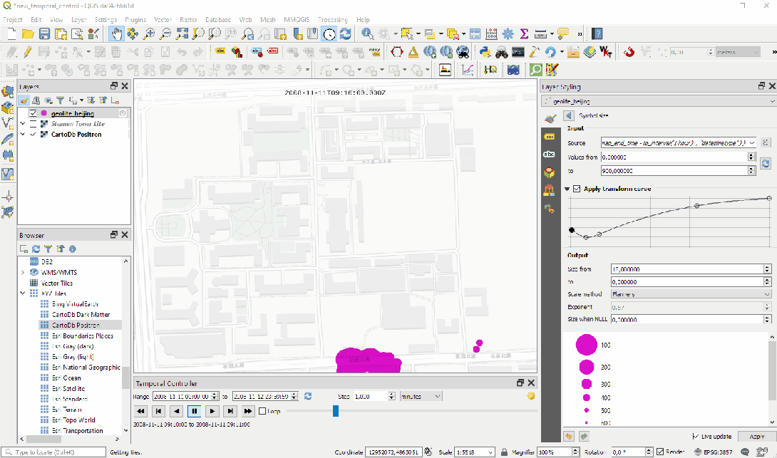
When researching this topic I found a great podcast from Mapscaping which featured GIS legend Anita Graser discussing the subject. Anita is one of the pioneers in this area, having developed the acclaimed Time Manager plugin for QGIS, back in 2011, to bridge the gap in how traditional GIS handles the temporal dimension.
How is temporal information stored and modelled?
Many GIS file formats support the collection of time data—in fact all of them can work with temporal information to some extent, but some do it more natively than others. In the vector data file type, you can add timestamps as attributes, either in the metadata or simply in the layer name. With raster data files, time information is usually put into the file name. Meanwhile, NetCDF—a more sophisticated file format typically used for meteorological and ocean data—has native time information support, making it easy to automate visualizations.
One thing to note when using time data is that the use of ISO timestamp format is generally recommended, as it makes it easier to analyze and exchange data. Anita points out:
There are way too many conventions for how to store time information. Think of the American Standard, for example: Month, day, and year. This format can mess up a lot of things. I recommend sticking to the ISO standard timestamp format: Year, month, and day. This is the only reliable format to sort dates.
Another complication comes with time zones, especially for datasets spread across multiple geographic regions. Anita advises here:
It’s better to have local timestamps, even if everything is stored in UTM or UTC. It will make an enormous difference if you have to track data and need to calculate movement speeds and directions.
Experience shows that there might be a number of potential surprises you should be aware of when working with multiple time zones. For example, in a database environment like PostGIS, the server has specific time zone settings: It’s either your local time zone or set to UTC. However, in some cases, it may try to convert data from UTC to local time in the background—making you wonder why there’s suddenly a two-hour gap between the data you’re looking at and what you see in your raw database!
Analyzing and visualizing space and time
Analyzing 4D data is highly complex as it requires both temporal and spatial correlations to be taken into account. Assessing both the temporal and spatial dimensions of data adds significant complexity to the data analysis process.
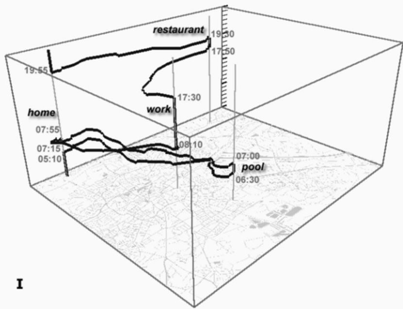
 One of the analysis methods for visualization of simple 4D datasets is by using so-called space-time cubes, where the x and y planes represent the spatial aspect of the data while time is modelled onto the z-axis. With these, you can perform a simple visual exploration of those data sets with limited movement: If you only see a vertical line, it’s easy to tell that there is no change in the x and y dimensions, and therefore the object is stationary.
On the other hand, if you see a diagonal, you can tell that your target object is travelling, and from the degree of ‘steepness’ of that diagonal, you can intuit how fast or slow that movement is. For multiple objects, it is possible to tell if they come together at any point along the way and whether they spend an extended period of time together at that location.
This method is a simple visualization tool for exploratory analysis—it doesn’t come with automatic tests. For a simple question like the one above (did your objects really meet in the same space at the same time?), you can have a look yourself if you have something to plot in 3D. However, once you have four or more objects, it becomes difficult to see patterns because it gets very messy, very quickly. This is the challenge of exploring larger data sets or those that contain greater amounts of movement.
What does the future bring?
Although the field of temporal analytics in GIS is still in its early days, the situation is improving. In mid-2020, QGIS v.3.14 added native temporal support for vector, raster and mesh layers. Each layer now has a new ‘Temporal’ tab within ‘Layer Properties’.
Esri has been actively supporting temporal analysis as well. Moreover, Open Geospatial Consortium (OGC) recognizes this capability gap, and there are a number of standardization initiatives happening as we speak.
So: Is GIS 3D or 4D?
It seems that by its very nature GIS has been designed to work with 2D and 3D data. Initially, the time variable was not considered to be critical, as there was limited data collection, and very few use cases for four-dimensional data analysis. As the fourth dimension started to become increasingly relevant, the geospatial community came to realize that GIS design is an inherently three-dimensional framework, and working with time proved difficult due to both complexity and lack of standardization. Fortunately, some brilliant minds have been working on this problem for a few years now, and we can say with confidence that GIS will soon become truly four-dimensional.