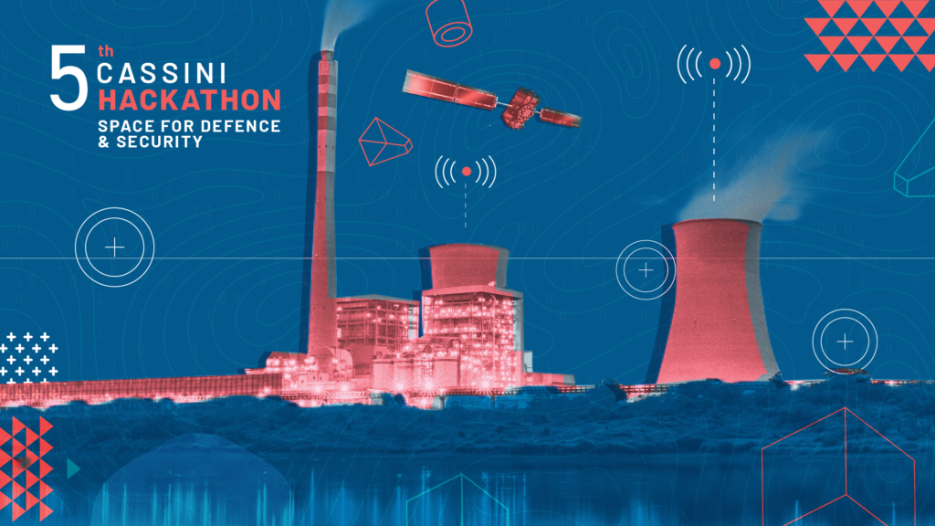
Important! Join CASSINI Hackathon focused on space and EO technology for defence and security

CASSINI Hackathons are events that bring together teams of engineers, scientists, designers, and developers to work on innovative solutions related to space science. The 5th edition of the event is finally happening on 24-26 March 2023. The participants will work towards leveraging EU space technologies to positively impact the European defence and security sector!
Your team will need to focus on developing ideas based on at least one of the following technologies:
- geospatial information from Copernicus Earth Observation data and its services
- positioning technologies from Galileo & EGNOS
- emerging digital technologies (e.g. machine learning, augmented/virtual reality or blockchain)
What are the challenges to be solved?
Each hacking team will need to select one of three challenges. The challenges require them to design products, devices or services with a specific goal:
- Enabling cross-terrain mobility
Develop concepts, products or services to enable cross-terrain mobility of emergency response teams, civil protection teams and humanitarian aid forces.
- Making the seas more secure
Develop concepts, products or services to enable maritime intelligence on direct security threats, organised crime and environmental hazards.
- Protecting our critical infrastructure
Develop concepts, products or services to assess the risk of disruption of critical infrastructure and plan for mitigation and recovery
scenarios.
Where, when and how to participate?
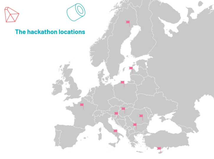
CASSINI Hackathon takes place simultaneously across 10 different locations in Europe, including: France, Italy, Poland, Croatia, Hungary, Latvia, Sweden, Romania, Bulgaria and Cyprus. You should register your team by March 17th. Each site features its own unique set of experts, prizes, and additional special features. Participants can select any location they wish.
No previous space experience is required! This is your chance to engage with the sector, even if it’s for the first time, as the event aims to bring together individuals from diverse backgrounds. The application process couldn’t be more straightforward: Choose a location, select a challenge and decide how you’ll leverage EU space technologies to enhance the defence and security of Europe.
Is it worth it?
Hackathons are a great way to push your creative mind to develop extraordinary ideas in a short time. It’s just three days that can change your life and accelerate your career. You don’t need to be a great developer or geospatial expert. You get plenty of support from the experts during the event, but you need a solid drive to create great products or services that are enabled by space technologies. The hackathon is open to anyone with a passion for entrepreneurship and technology.
DON’T WAIT UP! LEARN MORE HERE!
#Events


Next article
If you’ve ever tried to buy a GIS software license from one of the legacy GIS companies in the space, you’ll know that it can be quite a tedious process. You’re forced to comb through tons of different licensing options, engage in drawn-out calls and meetings with aggressive sales teams, and it often requires lots of back and forth to get to the solution that you’re after. This is not even mentioning the cost that comes with this. For example, just look at this Esri price list which shows that if you want to collaborate on a server environment and undertake some advanced processing, you’re probably going to be paying hundreds of thousands of dollars at the end of the day.
For many small and medium-sized companies, this is simply not feasible because the costs and complexity can be prohibitive. But even for large companies, the costs involved are often the barrier that stands in the way of full-scale GIS adoption. The natural alternative is to go open-source and use things like QGIS or PostGIS, but these reach their limits when you need to collaborate in the cloud or on a server. In addition, the investment required to process the data at scale (eg. to set up specific geospatial components for Kubernetes and microservices) remains significant.
Why is it the case that these options are so expensive? Why can startups like Mapbox or GIS Cloud offer similar functionality at a fraction of the cost? In this article, I want to explore this and ask the question – do GIS systems must be that expensive?
Why are Legacy Systems So Expensive?
I started my investigation by talking to some high-level executives from top GIS vendors and was shocked by what I discovered. These companies don’t feel any pressure or incentive to evolve their licensing model into modern norms because the majority of their revenue is coming from the public sector, government institutions, and defence clients. These organizations are not price-sensitive and have the software so deeply integrated into their systems that they are more than happy to pay whatever they need to pay to keep the software running.
Changing GIS software would be a mammoth task for these clients and would likely cost a lot more – or at least that’s the rationalization made to stick to the status quo. The budgets for these GIS solutions have been engrained for years, and no one questions it. This is a very similar paradigm to what we see with companies like SAP, Oracle, Cisco, and the like – who have such deep buy-in into their ecosystem, that they don’t face the same competitive pressures that other software does. As such, there is no reason to change.
As a result, GIS companies are reluctant to change their pricing model to suit the rest of the market because they risk alienating the large clients who represent the lion’s share of their revenue. Instead, companies like Esri are investing up to 25% of their revenue in product development and R&D to come up with new solutions or acquire companies with their existing client base to provide the growth that they seek. Esri and other “legacy players” are doing a great job in terms of innovation and product discovery, but this comes at the cost of making the industry-standard GIS software more affordable and accessible to a broader market.
What About Open-Source? Isn’t it More Affordable?
Open-source software has come a long way in the GIS space, and it does offer a viable alternative for many. QGIS, for example, is an excellent alternative to ArcGIS Desktop or Pro, and many organizations rave about its functionality. In Europe, where the sentiment for open-source is much more pronounced, a number of large enterprises and public sector clients are moving to QGIS, pulling the entire industry with them. For online collaboration or server-based solutions, there are also great tools like Geoserver, PostGIS, OpenLayers, GeoExt, or Geonode that are leading the way.
The challenge with implementing these open-source tools at scale is that you need a strong software development function that can piece together these components into a workable system and an even larger team to transition from an MVP to a scalable enterprise-grade ecosystem. This next level of scalability involves nuanced integration, cybersecurity, documentation, and much more. As such, many companies end up investing similar amounts of money and effort to make these work – and this is a problem for organizations who don’t see it as their core activity.
Just because it’s open-source, it doesn’t mean that the barrier to entry is not there.
What About Hybrid Open-Source?
Another trend that we see in the geospatial sector is a hybrid approach that combines open-source tools such as QGIS which power the desktop processing, and startup options like GIS Cloud or Mapbox, which look after the cloud and server collaboration. These can be integrated seamlessly thanks to dedicated plugins and toolboxes and offer the full suite of features without breaking the bank.
This is a great option for many because it can save a lot of time and money. Once you’ve set your workflows up and scripted some custom integrations you can get going in just a few days. This is much faster than setting up AirGIS server environments which can take weeks.
On the top, going “hybrid” gives much greater flexibility as you are not operating in a closed environment. You can easily connect to external databases and scale your operations with much bigger datasets. Also with platforms like GIS Cloud you easily set up your own WMS and WMF servers without having to buy expensive Esri licenses and tools such as Carto or Mapbox let you style your maps in the most creative way. Finally, there are no limitations on how you share your maps internally and externally which has been always a big disadvantage for closed ecosystems such as Esri.
We’ve seen a lot of organizations go this way as you’re able to get the best of both worlds – the power of open-source desktop tools and the cloud benefits of large-scale data processing, collaboration, and publishing. This is very positive for the industry as a whole because it enables wider use of these tools.
Comparing Prices
Let’s look at the numbers. For our comparison, let’s assume that you have a typical GIS team of 5 members and they will need to do some large data processing, collaborate on the dataset, and publish results to the rest of the organization. Here’s how that would stack up:
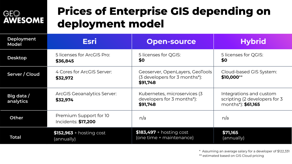
As you can see, the numbers strongly point to a hybrid solution that can significantly lower the barriers to entry and make industry-leading GIS solutions more accessible.
Conclusion
Without the incentives for legacy GIS providers to bring their prices down, organizations must look elsewhere to get the functionality that they need. As we’ve seen above, while open-source solutions are very powerful, the development and maintenance costs should not be underestimated. Hybrid solutions seem very well placed to fit that need, allowing greater flexibility and agility for organizations who want to get the best of both worlds.
It remains to be seen how the industry will morph from here, but here’s to hoping that more affordable tools push the sector forward and encourage more innovative pricing models that can bring the technology to more people.