
In the humanitarian sector, as elsewhere, being able to predict the future is becoming less
science fiction and more science fact. Predictive modelling aimed at forecasting crisis events, so that steps can be taken to reduce or prevent their impacts, is becoming increasingly prevalent. We are witnessing a noticeable shift in emphasis from the logistics of response to anticipatory action.
As part of this shift, a lot of effort is going into data preparedness, aimed at ensuring that when crises occur, those coordinating the responses have immediate access to the baseline
information they need to rapidly understand and analyse the impacts. MapAction, an international humanitarian mapping charity, is active in both areas. We have been working to actively and collaboratively curate and develop humanitarian data sets that we know are
needed for mapping in any disaster or emergency (the subject of a future geoawesomeness
blog), and we are co-operating with partners to develop and validate new predictive approaches.
Even before COVID-19 significantly increased humanitarian need globally in a short timeframe, insight from predictive analytics (PA) was being used to improve humanitarian supply chains and reduce costs, as well as to forecast things like food shortages and movements of displaced people. The World Bank, the World Food Program, the Red Cross, Start Network and Save the Children are among the organisations actively applying PA to solve these types of problems. COVID has precipitated this by making humanitarian work even more difficult and complex while resources are stretched even further, necessitating smarter, more agile approaches.
The shift towards anticipatory action is also being encouraged by The United Nations Office for the Coordination of Humanitarian Affairs (OCHA) which aims to facilitate the widespread
use of current and historical data and PA tools to predict emergency scenarios or specific aspects of them – such as their magnitude, duration or likely impacts – in order to trigger appropriate responses ahead of time. As part of this goal, it has established anticipatory action frameworks for a number of high-risk countries incorporating three elements: a predictive model or forecast; pre-arranged financing based on triggers; and a pre-agreed
action plan.
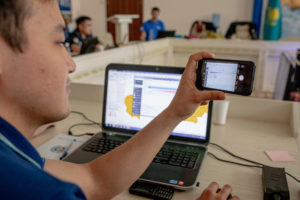
The UN’s Centre for Humanitarian Data in the Hague has a PA team which is working to develop new predictive models in this area, as well as supporting others to develop and use
their own models. For the past year, MapAction has had a data scientist based at the Centre
to collaborate and share learning, bringing our geospatial expertise to the table.
There have already been several fruitful results of this ongoing cooperation. Together with other other partners, notably the Johns Hopkins University Applied Physics Laboratory, we developed a model to predict the scale, severity and duration of the coronavirus outbreak within specific countries, including its likely effects on vulnerable groups. This model is being used to support short-term operational decision-making in an effort to protect and save more lives.
We have also contributed to a drought-related anticipatory action framework to predict potential food shortages caused by drought in Somalia and Ethiopia. The MapAction team reviewed past literature, evaluated available satellite images, and created a prototype drought model in Google Earth Engine. The resulting indicators were used to trigger an early release of critically needed funds from the UN’s Central Emergency Response Fund (CERF).
Another project has involved the implementation and validation of an approach for mapping flooding from satellite imagery. This has been used to help evaluate the impact of recent anticipatory action in Bangladesh. Last July, the European Commission’s Global Flood Awareness System predicted a high probability of severe flooding in Bangladesh, which is vulnerable to flooding from monsoons from June to September. This trigger was enough to release funding to distribute assistance including cash, livestock feed, storage drums, and hygiene, dignity and health kits in the fastest-ever allocation of CERF funds since the Fund’s inception in 2005.
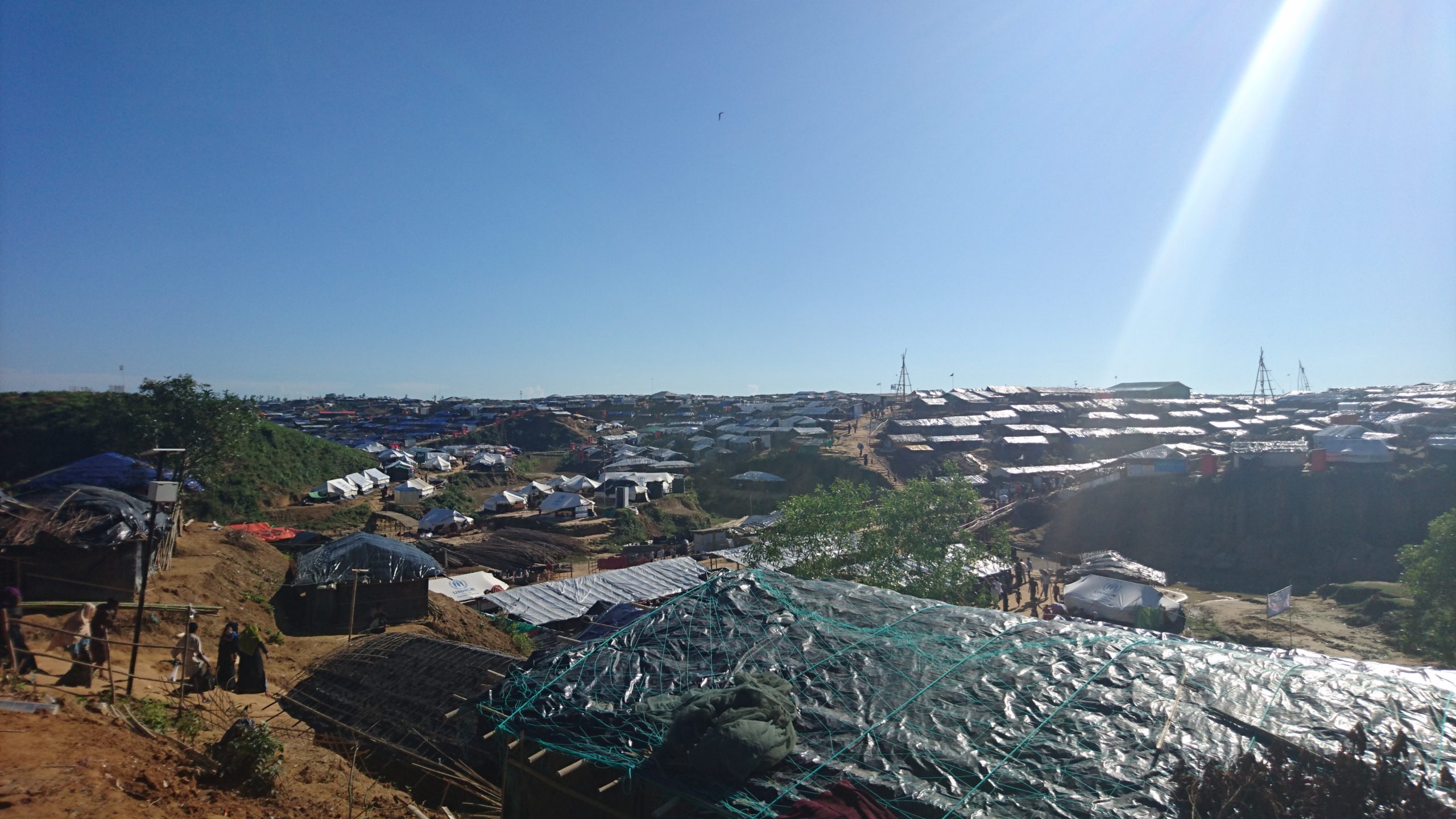
To better understand how this aid was helpful to those affected, the PA team needed to know exactly when, where, and for how long flooding occurred. We analysed a number of satellite images from Bangladesh and then used the outputs to develop a simple model indicating how the flooding occurred over space and time. We validated these estimates of historical flooding against external data sources (such as river discharge measurements) to
be confident in their accuracy. After it had been validated in this way, MapAction was then able to test out parts of this analysis with confidence in the responses to Hurricanes Eta and Iota in Central America in November, when torrential rains falling on saturated ground and steep valleys caused devastating floods and landslides.
We’re continuing work with the PA team on flooding-related anticipatory action by investigating the predictive power of various hydrological forecasts, through comparison against historical flooding data.
As the accuracy of forecasts and predictive modelling continues to improve, some believe that anticipatory action will become more important than disaster response in the future. Humanitarian crises are incredibly complex. Anything that helps to unpick that complexity to better understand and prepare for the interconnected factors affecting their trajectory and the impacts on those caught up in them is to be warmly welcomed.


#

Next article
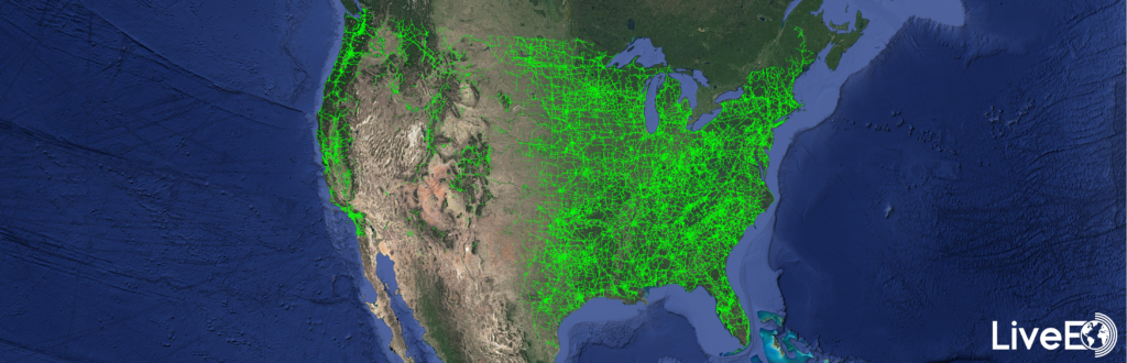
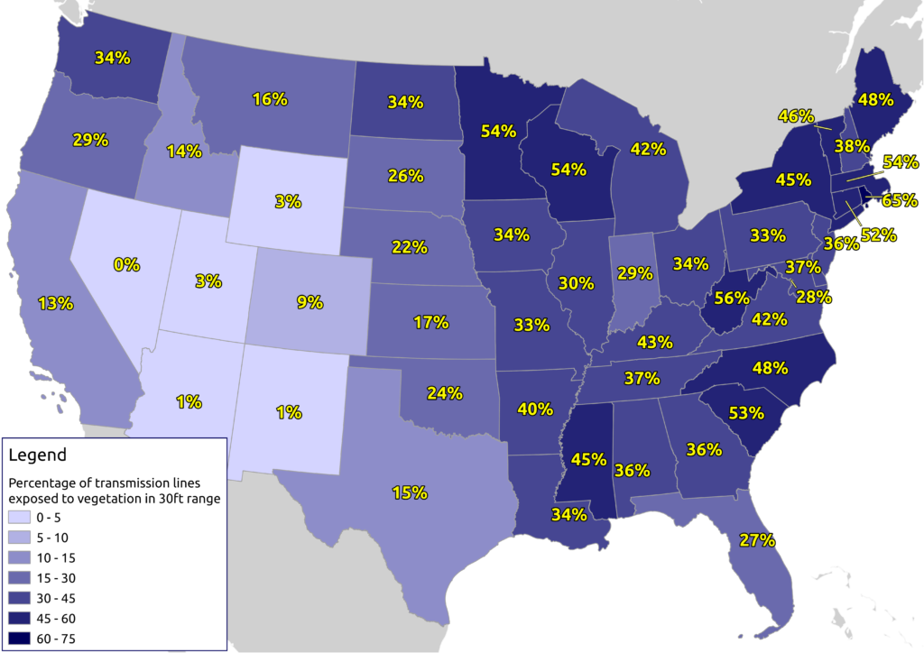
Recently, the Berlin-based space company LiveEO published the results of an amazing study: They analysed the entire U.S. electrical transmission grid based on satellite data to detect vegetation encroachment from space. The results reveal exciting insights about the vegetation condition alongside nearly 574,000 miles of overhead lines.
Besides the sole detection of vegetation, the study aimed to identify regions with a higher-than-average vegetation exposure and lays the baseline for high-resolution analysis of these areas.
Vegetation management is one of the biggest challenges and operational cost factors for utility companies in maintaining their assets, causing up to 56% of externally triggered power interruptions. In the United States alone, approximately US$6 billion is spent on vegetation maintenance by utility companies annually.
LiveEO’s extraordinary analysis is based on publicly available geospatial data from the U.S. transmission network and imagery from the Sentinel-2 mission from the Copernicus program of the European Commission and the European Space Agency. In total, LiveEO evaluated the area around 573,323 miles of power lines based on space-borne data processed on servers in the United States to determine the length of power lines threatened by vegetation. More than 1.7 million square miles (~45% of the total continental U.S. area) of imagery have been processed by LiveEO, equivalent to approximately 15,000 scenes of satellite imagery.
“The scale combined with the detail of the analysis represents a milestone in satellite data analytics for utility companies and proves that satellite data represents a viable alternative for vegetation management to Lidar or foot patrols.” says LiveEO Co-Founder Daniel Seidel. “Additionally, these insights can be made actionable directly via our toolset of mobile and web apps, and API integrations to improve workforce efficiency in the field and to realize OPEX saving.” adds LiveEO Co-Founder Sven Przywarra.
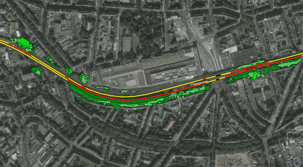
LiveEO found that a total of roughly 50% of the United States transmission network, equalling 291,000 miles, is exposed to vegetation closer than 90 feet. More specifically, they identified 166,000 miles that contained vegetation in a 30 ft. vicinity.
With this study’s help, utility companies get an initial overview of the vegetation condition alongside their assets. In addition to this large scale analysis LiveEO is highly experienced in the extremely accurate and efficient investigation of vegetation height, condition, and species detection alongside electrical transmission and distribution lines, railways and other infrastructure grids:
Height and health of vegetation for example improve the risk assessment of vegetation near overhead power lines enabling an extended cycle trimming that takes into account how tall the trees and shrubs are, whether they are healthy or diseased, and also at what distance they grow from the grid. It also allows hazard trees to be correctly identified and removed, helping in storm and hurricane safety.
Overall LiveEO’s solution allows utilities to improve their UVM (utility vegetation management process) to increase grid reliability, safety and to save up to 35% of operational vegetation management cost.
Another use case for satellite-based vegetation analysis is the identification of fire-prone areas near power lines. In addition to dry conditions and exceptional heat, growing near power lines cause wildfires.
LiveEO is already helping utilities identify fire-prone areas and conduct highly accurate post-wildfire inspections for rapid restoration activities.
With a wide range of utility and infrastructure customers in North America, Europe, and Australia, LiveEO has demonstrated its capabilities in numerous pilot projects and large-scale deployments on an entire countries’ scale.
To strengthen contact with its customers through physical presence, LiveEO opened an office branch on the East Coast of the U.S. in late 2020.
More information about LiveEO’s analysis can be found on their website. LiveEO offers infrastructure customers a free sample analysis of their network.