Exclusive: Win a trip to Germany by mapping undermapped OSM regions with Mapillary

Did you know there are more than 400,000 places which are yet to be mapped in the popular open-source data tool OpenStreetMap? This means there are more than 400,000 places on the planet which are vulnerable to a humanitarian crisis.
In the absence of street-level imagery and comprehensive data on buildings, roads, and key lifeline infrastructure, relief workers can neither get a clear picture of the impact of a disaster, nor can they determine the urgent needs of the population effectively.
And this is a big concern for the Humanitarian OpenStreetMap Team (HOT) – the international group of volunteer mappers who work with communities and disaster management agencies to understand, mitigate, and manage risk from hazards like hurricanes, earthquakes, floods, cyclones, and volcanic eruptions.
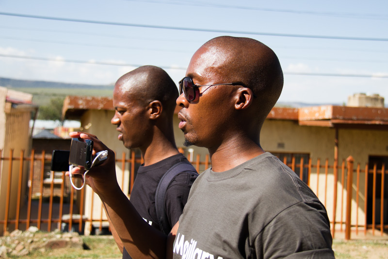
So, to accelerate the map data collection for the undermapped regions in OpenStreetMap, HOT is launching a new campaign called #map2020 in collaboration with Mapillary, the street-level imagery platform that scales and automates mapping.
What makes this campaign extra special? #map2020 will qualify local mappers to enter the race for two fully-funded trips to HOT Summit which is happening in Germany in September 2019! Since all images on Mapillary are free to use for editing OpenStreetMap, you simply need to use Mapillary’s mobile app to capture and upload images to the campaign.
#map2020 winner selection
HOT and Mapillary will together select the winners based on how a project can be used to address a humanitarian challenge or aid in a development initiative. This can include anything from assessing how resilient certain areas are to flooding, to updating the maps of an area that is recovering from a disaster. The winners will present their mapping projects at HOT Summit.
Stressing on the importance of access to map data, Rebecca Firth, Director of Community and Partnerships at HOT, says, “It saves lives and reduces suffering, which is why we work closely with local communities to scale up map data collection wherever data is missing. We’re hoping this campaign will encourage and shine a light on the important work that local mappers undertake in collecting map data before, during, and after disaster strikes.”
For Ed Neerhut, Strategic Partnerships Manager at Mapillary, HOT and Mapillary are on a joint mission to build tools that speed up filling the gaps in missing map data. Highlighting the role of street-level imagery in addressing challenges like flood prevention, earthquake resilience, and humanitarian assistance, Neerhut says, “With #map2020, we will provide support to local organizations that will allow them to integrate street-level imagery into their projects from the beginning. By inviting two projects to the HOT Summit in Germany, we hope their learnings will prove useful for the wider humanitarian mapping community.”
The campaign and call for projects go live today and remain open until June 1, 2019. The winners of #map2020 will be announced on July 2.
So, don’t wait. If there ever was a time to unleash the mapmaker in you, it’s now!

#Business


Next article
New geospatial tool makes planet-wide change detection possible in near real-time
What happens when you combine remotely-sensed data with computer vision and machine learning technologies? You get to observe global socio-economic trends, and keep an eye on the planet as if it were a living entity, at the speed of business.
At Geoawesomeness, we have often written about highly-specialized geospatial startups whose only job is to dig through the wealth of satellite imagery data captured by companies like Airbus and DigitalGlobe and extract extraordinary insights from them.
Read: This startup says it can solve geospatial industry’s big data problem
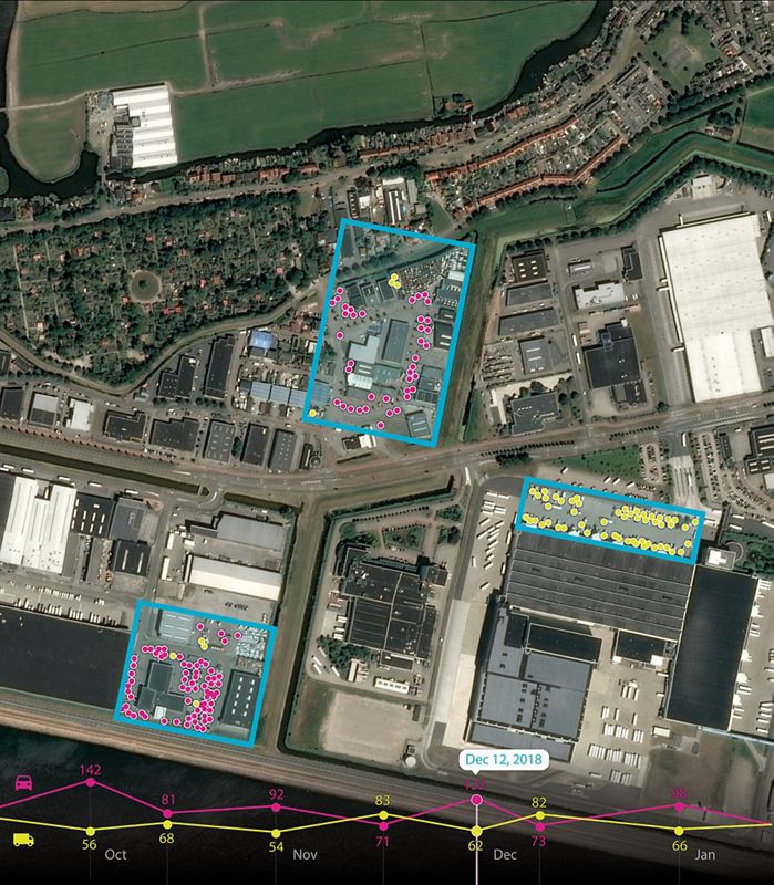
Last year, one of these startups – Orbital Insight – joined forces with satellite imagery bigwig Airbus Defence and Space to build a suite of geospatial analytics services and tools. Now, we are seeing the results of this partnership in the form of Earth Monitor – a geopolitical and economic insights tool which Airbus is making available through its OneAtlas platform.
Earth Monitor is powered by Orbital Insight’s proven machine learning and computer vision expertise to detect changes in infrastructure and land use in near real-time. The analytics tool can even identify and count objects like roads, homes, cars, trucks, etc.
Further, by leveraging Airbus’ exhaustive satellite imagery archives, Earth Monitor is able to identify trends and spot patterns, delivering advanced geospatial analysis and change-detection maps for customized areas of interest.
Dr. James Crawford, CEO and Founder of Orbital Insight, sees Earth Monitor as a unique opportunity because it allows customers to define the what, where and when in order to personalize the reports according to business needs. Meanwhile, Airbus’ Head of the Intelligence Business, Francois Lombard, is stressing that using Earth Monitor will enable customers to draw precise, timely and meaningful conclusions, allowing them to gain time and allocate resources to where it matters the most.
Now, if you are intrigued by this new geospatial analytics tool and want to know whether its key functions and applications are relevant to your business, you can attend the launch webinar on May 16, 2019, by registering here. A live Q&A session has also been planned after the webinar, so keep those questions handy!