
How We Responded to Covid-19 Pandemic by Mapping Ugandan Border Entry Towns (by MapUganda)

This post has been cross-posted from HOT News.
Timely provision of medical and non-medical supplies is critical for COVID-19 response, and the need to remember the undesirable demands to protect oneself from the disease has prompted the reinvention of risk communication with targeted messaging like the “Tonsemberera (Do not come close to me) campaign.” All over the world, the outbreak prompted the application of tools, such as digital and geospatial technology, for efficient responses, to enable the quick identification and isolation of infected individuals or families while also ensuring the efficient supply of daily needs such as food, especially among those that were gravely affected by the pandemic.
OpenStreetMap is one such platform that enables building tools and obtaining demographics without needing complex techniques. With the identification of buildings, access roads, and amenities, responders gain easy access to information, and so the planning and delivery of support services become more efficient. Unfortunately, the most affected areas in Uganda were the border districts that only existed as blank spots on OpenStreetMap. Map Uganda, together with Geo YouthMapppers, came forward through the HOT Microgrant program to support the availability of data for the planning and actions of government and field responders, such as the Ugandan Red Cross. The parties embarked on mapping buildings, roads, and identifiable amenities for porous border entry points to help create detailed maps to support and retool the Ugandan Red Cross Society and Ministry of Health surveillance efforts against the spread of the pandemic.
In spite of the lockdown of the airport in March and the strict monitoring and testing at official borders entry points, COVID-19 transmission still found its way into the country through the porous border points, carried by people entering from the neighboring countries of Kenya, Congo, and Tanzania. With support from a Rapid Response Microgrant, students and community members dedicated a piece of their time every day to contribute to the remote mapping of 27 border towns.
Data Collected
A series of trainings and work sessions using different tools, such as JOSM, ID Editor, Tasking Manager, Quantum GIS, Umap platform, were used to remotely prepare the data and information for the communities at the frontline of the awareness and risk communications against the pandemic.
- More than 250,000 buildings were added to the map
- Over 7000km of roads were collected
- More than 400km of waterways were also mapped in these all the border points.
- 27 Digital and paper maps were created.
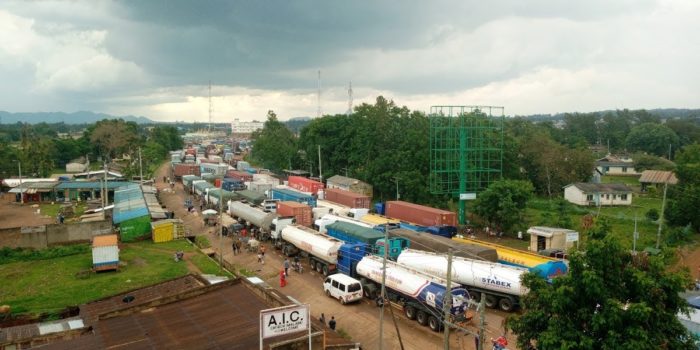
Cargo trucks lining up at the Malaba Border Point on the border of Uganda and Kenya as truck drivers wait to be tested for Covid-19 before they enter Uganda.
Insights from the mapped border towns
Among all the 27 border towns, Kyotera and Busia had the highest number of buildings. The access roads are primarily distributed across Kyotera, Elegu, Busia, Mutukula, and Moyo border towns, with Kyotera having the highest number of access roads. This attributes to the dense population of the town and puts its population at risk of an outbreak if there is a community infection within the area.
For further insights, please see these resources:


#Business


Next article
Using OpenStreetMap Data to Support Emergency Ambulance Response Service and Mapping of COVID-19 Amenities in Northeast Nigeria (by Humanitarian Mappers)
The lake Chad region (Nigeria, Chad, Cameroun, and Niger) has witnessed insurgency attacks since 2013, which have greatly impacted the people of the region, especially children and women. Currently, the BAY (Borno, Adamawa, and Yobe) states are the most affected. Because of the already degenerated socio-economic and health conditions of internally displaced persons in north-eastern Nigeria, it is crucial to deploy sustainable solutions that mitigate their insecurity, especially during the current COVID-19 pandemic.
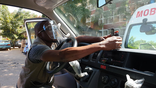
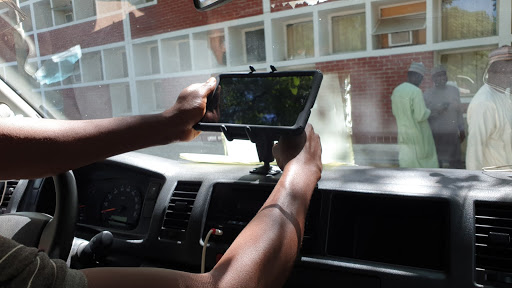
We are addressing this challenge through the use of collaborative mapping using the OpenStreetMap platform. We train community members to identify and map their communities and infrastructure, especially places related to health, emergency services, and displacement, such as roads, health facilities, isolation centers, safe spaces, etc. This data will be utilized by the community and institutions to respond to their needs. For instance, the state COVID-19 taskforce is managing cases and referrals through the efficient utilization of the OSMAnd navigation app by ambulance drivers while transporting patients.
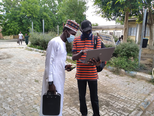
In order to ensure sustainability and ownership of this project, we identified and met with the Albaraka health spring foundation (AHSF) and the COVID-19 task force team, the former being our local implementing partners and the latter being the Government response team for COVID-19. Over 30 community mappers have been trained in the use and benefit of OpenStreetMap, while five field officers have been trained in data collection, and seven drivers trained in the use of OSMAnd for navigation and mapping.
Over 2,000 buildings, 950 km of roads, 1,000 health facilities, 1,264 amenities (IDP camps, schools, banks, etc.), COVID-19 infrastructures (point of entries, testing centers, etc.) were digitized. A youth mapper association was created within the University of Maiduguri, and one at Ramat Polytechnic is in the pipeline.
We are looking forward to an ongoing, biweekly mapping session with the community mappers, which will also teach other skills such as GIS, project management, and communication. We are targeting students, and this skill set will help them in school and after graduation. We have learned that it is possible when the community and government are involved and partnered with to have a continuous engagement process with the stakeholders because the process is always fluid.
In the words of Dr. Ibrahim Kida, COVID19 Taskform Team, Incident Manager, Emergency Operation:
There are so many infectious diseases that require an emergency response, which includes Hepatitis, HIV, and Cholera, and Covid-19 is one of the most threatening infectious diseases in the world. Road accidents and bomb explosions are not exceptional.
To continue this work with the help of the commissioner of health, Humanitarian Mappers will be working in collaboration with the Borno state government to enhance ambulance emergency response by training the drivers in how to use OpenStreetMap, which will help them get to where they are needed on time.
Update: Humanitarian Mappers is still holding their monthly meetup, which focuses on not just OpenStreetMap, but also capacity building in data collection, GIS, cartography, and more.