
In July we reported that HERE has been acquired by the consortium of German carmakers (BMW, Daimler and Audi) in the biggest mapping deal since… the acquisition of Navteq (predecessor of HERE) by Nokia and Tele Atlas by TomTom back in 2008.
Today it’s finally official. Gpsbusinessnews reports that the German antitrust authority has completed its review of the acquisition and has approved the agreement. Andreas Mundt, President of the authority commented:
“Our audit focused on the question of whether the merger could lead to the partitioning of other car manufacturers of digital map or whether the HERE competitor TomTom could be denied future access to automobile and supplier companies.”
The conclusions were apparently positive for HERE. Now we are waiting for the first steps under the new ownership. It will be interesting 1-2 years for the industry.

#Business


Next article
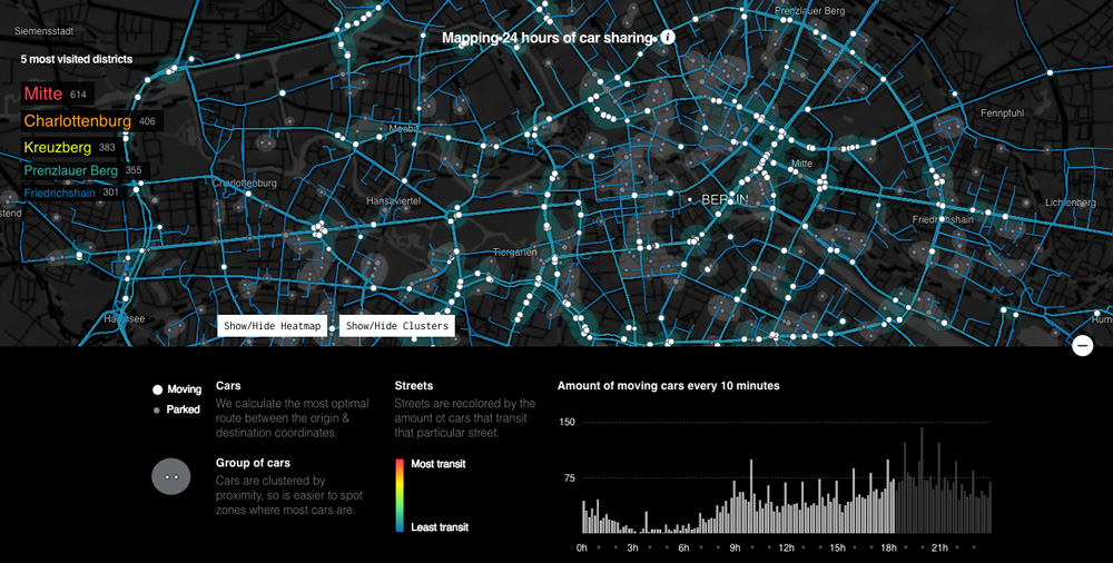
Interesting project by Data Storytelling Group. They got an access to data from German car sharing company DriveNow and created an awesome visualisation of urban mobility in Berlin. DriverNow offer this cool new short-term car renting model where you check and book the nearest car via app and you leave it off wherever you want.
The visualisation has been made based on origin-destination matrix provided by DriveNow. Based on the location and time of the beginning and end of each journey guys from Data Storytelling Group estimated the optimal routes between these two points for each car.
When you start the launch the visualisation it starts from the midnight and goes through 24h of a typical day in Berlin. The timeline on the bottom of the screen shows the time and the number of moving cars every 10 minutes. You can use it also a navigation bar to move forward to a particular moment in time. You can also turn on a heat map feature which will show you how streets are changing colour as the day progresses.
The map differentiates cars which are driving and which are parked. It also shows the top most visit districts on Berlin.
Really cool visualisation.
source: Data Storytelling Group