

Starting from Friday, February 19th all hobby drone owners in the US above 13 years old who own a device weighting between 0.55-50 pounds (0.25-22.5 kg) must be registered with the FAA. You haven’t done it yet and you’re wondering what problems you might face?
In theory the rules are quite strict. The civil penalties for not registering your device include a fine of up to $27,500. Criminal penalties include a fine of up to $250,000 and up to three years in jail. In practice you probably don’t have to worry about the FAA tracking down drown owners without a registration number. But if your drone gets caught up in some sort of incident and you are not registered you might face some stiff penalties.
You can compare it to driving without a valid driving licence. When you have it nothing will happen to you. One time you forget it you will surely be stopped by a police patrol. In fact there is no reason not to register your drone, and in the likelihood that something goes wrong, it’s definitely better to be safe than sorry.
FAA said that 342,000 drone owners have been registered to the database until the end of last week which is a half of estimated 1 million aircrafts sold in the US last year. So if you haven’t done it yet it is worth so spend $5 and register.

#Business


Next article
Facebook created the most detailed Population Density Map to bring the rest of the world online
Facebook has been working on the Aquila project to deliver internet connectivity using solar-powered drones to 3rd world countries for a while already. The company says that 10 percent of the world’s population lives in places where the Internet is still not available. Other companies including Google are also working on solutions aiming to beam the network connectivity from the sky. But the technology to provide the connectivity is only a one side of the equation, another important thing is to analyze where it is actually needed.
Today Facebook announced that is has handled that problem by generating the most detailed available population maps of 20 countries including Algeria, Burkina Faso, Cameroon, Egypt, Ethiopia, Ghana, India, Ivory Coast, Kenya, Madagascar, Mexico, Mozambique, Nigeria, South Africa, Sri Lanka, Tanzania, Turkey, Uganda, Ukraine and Uzbekistan. The Project is a cooperation of the Facebook’s Connectivity Lab – technical arm of its Internet.org initiative that deals with delivering internet to rural areas and developing countries, and the Columbia University which developed the previous most accurate population density map together with the World Bank.
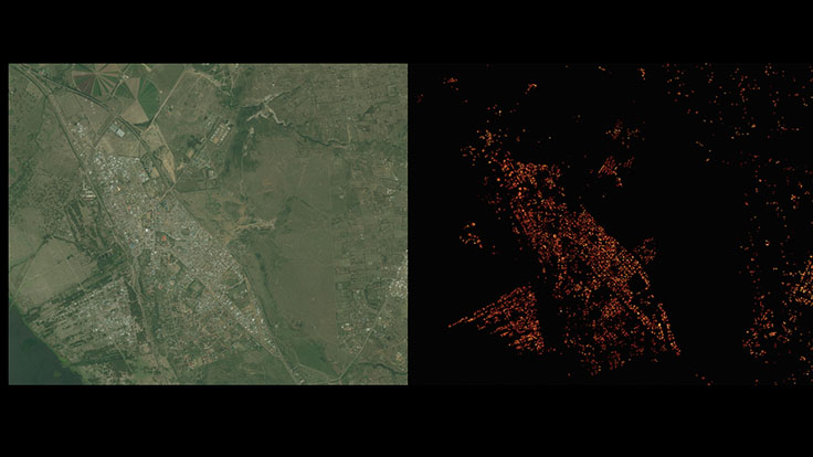
The methodology was to train algorithms in detecting human activity based on satellite images (exactly 14.6 billion images, weighing 350 terabytes). The first step was to detect buildings. Once the footprints were laid out, Facebook assigned weights to each building. Then using census data the population data has been redistributed according to weight of each building that acted as a proxy for where and how people live. This is not a perfect methodology but it is commonly used in a similar projects as the least error-prone way of determining how many people lived in a particular location.
The results are pretty amazing. You get a population density map with 5-10 meters resolution. “Later this year, we will be releasing this data to the general public. We believe this data has many more impactful applications, such as socio-economic research and risk assessment for natural disasters”, Facebook said in a statement.
Facebook’s analysis of the population density in Naivasha, Kenya
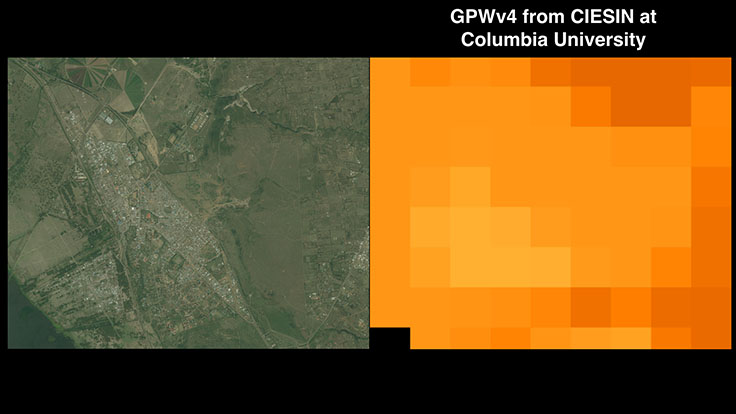
Previous most accurate population spatial distribution data from the Columbia University
Meanwhile, at Mobile World Congress 2016 in Barcelona the company has launched a new initiative – Telecom Infra Project (TIP) – that aims to come up with new ways to build and design telecom network infrastructure. The goal of the project is to make mobile internet connections better for users who are already online, as well as establishing the best way it can bring new users online.
All this combined shows that Facebook is doing significant efforts to bring the remaining 1 billion people online. It’s great that the company is planning to openly release the population density maps. As GeoGeeks we would like to also see a spatial relations map of the existing 1.6 billion users of the social network.