
The LightSquared/GPS Controversy has been dominating the news front in the recent years and although the US government has “conditional” banned the LightSquared allocation, the company has challenged it and The recent U.S governmental accountability report regarding it is a good indication of just how complicated the issue is (read more). The issue opens up an important discussion regarding current GNSS spectrum allocations and the proposals to utilise part of the S-band for GNSS operations in the future.
What is the controversy all about?
Simply put, a company called LightSquared wants to use part of the L-band spectrum that is close to the GPS operating frequency which results in interference with the GPS signals or at least many experts and GPS companies believe that it will cause severe interference that will potentially lead to no GPS service. There is even a coalition of GPS companies in this regard – SaveOurGPS. There are of course several studies and white papers that have been published to substantiate the claims against the LightSquared Allocation and personally I agree with the interference concerns that have been raised.
GNSS Spectrum
All the current GNSS Positioning constellation operate in the L-band spectrum. The L-band of the RF spectrum is “prime and pristine” property to put it in real estate terms; a very favourable portion of the Radio Frequency Spectrum. It makes Satellite transmissions much simpler with respect to electronics and power requirements when compared to other RFs. Naturally when there is a proposal to “alter” the equilibrium by allocating frequencies close to the current GNSS allocation, the GNSS community is going to raise an alarm.
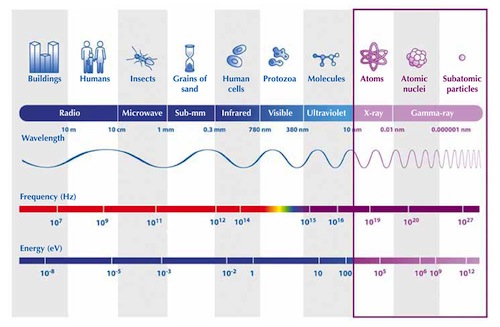
S-Band proposals and future GNSS allocations
Today, we have satellites operating in a wide range of the EM spectrum from Radio Wavelengths (GNSS, etc) to Gamma Ray (Satellite Telescopic Missions). We know the benefits of having multiple frequencies in GNSS with respect to accuracy, availability and PNT applications so it is only natural that the GNSS community wants to expand its footprint. Here is an interesting article on GNSS signals in S-Band. The RF spectrum is crowded with many applications and technologies requiring the spectrum to transmit and receive signals.
At this point, a proposal to utilize the S-Band spectrum for GNSS operations is going to trigger reactions from private players that may possibly like to utilize the same band (or nearby band) that GNSS intends to use in future and going by the Lightsquared incident there is going to be a lot of criticism and lobbying if GNSS again plays the interference card to thwart such plans by commercial players.
Besides the commercial angle, we need to remember that this involves many modifications in signal generation, transmission and reception. The higher the frequency, the more power we need to generate the signals so if we just move the GNSS spectrum from L-band (1-2 GHz) to S-band (2-4 GHz) we end up doubling the power requirements of the satellites; something that is not very desirable. This is coupled with the complex electronics that is needed to generate the high frequency signals and of course the changes that are required with the design of the GNSS receivers.
GPS Modernization and the Future of GNSS
With GPS getting modernized with additional L-band signals (L2C, L5 and L1C) all of which are civilian in nature, it would be interesting to see how the proposal for Sband is presented. However at the same time, it is very important that GPS and other GNSS constellations make complete use of the allocated L-Band spectrum and also try come up with solutions to mitigate the effects of interference with RF allocations that are closer to the GNSS spectrum. RF is a finite resource and it is natural that commercial interests are constantly pushing the governments to let them use a particular frequency that is currently not being used; this lobbying is not going to stop in the coming years as well. So it would be wiser for the GNSS receiver industry to work with the GNSS Service Provider i.e. the Governments to try and develop technologies that mitigate the interference.
In my view, it makes sense to undertake further research to fully understand the benefits and challenges in using S-Band for GNSS operations. What do you guys think?


#


Next article

 In recent times one of the most interesting innovations in mapping technologies is the technology of tiny civil drones.
For Sometimes now, I and a friend have been foraging the web in search of the best of this technology and contemplating seriously on acquiring one as soon as possible.
For me, SenseFly is making a lot sense right now as they have added additional solution for capturing amazing oblique aerial images without the use of the camera gimbal.
SenseFly’s eBee drone and Swinglet CAM designed for mapping missions are now able to quickly acquire great oblique images to complement your mapping project courtesy of the drone aerobatics solution inbuilt.
These amazing oblique images can become very handy for additional documentation about the project and for reporting.
According to parrot.com, this patent pending technology is based on a propriatary control algorithm that takes oblique images of photo targets without the need of a camera gimbal, enabling senseFly’s ultralight mapping drones to take aerial shots with up to 45° inclination from the photo target.
The algorithms running onboard the drone’s autopilot automatically place and orient the drone based on the defined image resolution and inclination (0-45°) selected by the operator. The drone then adapts its trajectory according to local wind and target altitude.
Having a system that positions the camera autonomously with respect to the photo target enables senseFly’s drone systems to take precise oblique images without the need for live video feedback or a camera gimbal.
As these new techniques do not require any hardware changes, this novelty is freely available to the full community of eBee and swinglet CAM (late 2012 model) users with the new release of eMotion 2.2.
Beside creating stunning visuals, senseFly’s latest release of Postflight Terra 3D will enable users to go one step further and add these oblique images to a standard mapping flight, adding visibility to facades and vertical surfaces.
A word from the CTO, video below:
Source: Parrot.com