
Back in 2012, Google launched the Maps Coordinate service, a tool for managing mobile workforces. Using this web service, businesses could track and dispatch their employees like delivery guys, truck drivers or sales reps.
It seems that the never made it to the mainstream. Last week Google sent an email to existing subscribers, telling them that the service will shut down in January, 2016. Google was never shy about closing its services, even the popular ones (remember Google Reader?). Additionally Google announced in a statement:
Maps and location information are valuable tools for businesses — whether it’s helping people find your store locations or identifying sales opportunities across town. To help our Maps for Work customers continue to get the highest impact from our products, in 2015 we’ll focus on helping customers deliver location information via our Maps APIs and shift away from selling any non-Maps API products. We’ll support our Maps for Work customers through their contracts and work closely with them and our partners through this transition.
It seems that Google will now clean up its business-oriented mapping services and put everything under the Google Maps for Work portfolio, which includes a collection of APIs that allows users to overlay custom data on a personalized Google map. Google Maps Coordinate site already redirects to Google Maps for Work.

#Business


Next article

The Geospatial industry has greatly benefited from substantial advances in field of Computer Science and Technology. In the last few decades, these advances have not only made GIS much more accessible but have also helped the Geospatial industry evolve itself. An evolution, most of us probably don’t notice that much.
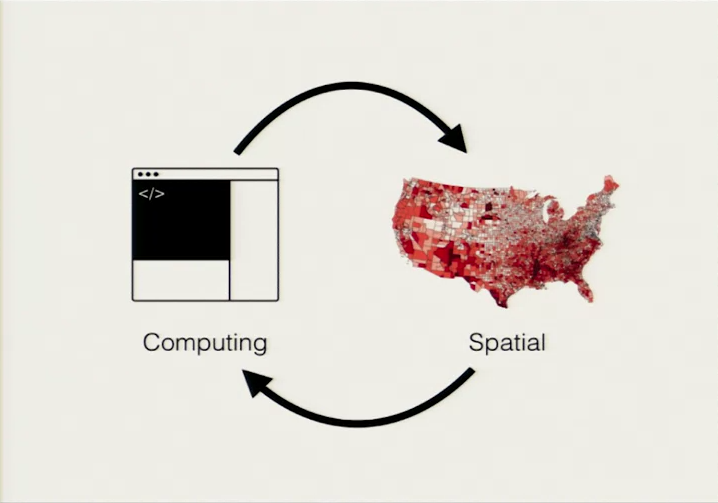
Source: From GPS and Google Maps to Spatial Computing by Dr. Brent Hecht, Shashi Shekhar
Defining the Geospatial industry
More often than not, we see references to the US Department of Labor report that identified Geospatial technology (besides nanotechnology and biotechnology), as one of the three most important high-growth industries of the 21st century. But then, what exactly does the Geospatial industry encompass?
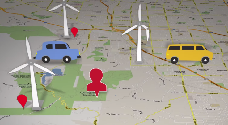
Would it be correct to say that any field/domain that uses spatial information and maps, is part of the Geospatial industry? Self-driving cars, Connected bikes, UAVs, Wearables, Augmented Reality, all of these technologies have spatial data and maps as one of their primary data sources be it Indoor Maps or just the conventional outdoor maps. The GIS industry isn’t the only use that is using maps anymore, everyone is and that is truly exciting!
GIS on the Cloud & 4D GIS
Thanks to the internet and Cloud storage, we can seamlessly switch from our computers to our mobile phones and still have all the data we need. It is no surprise that JavaScript is one of the most used programming languages in the world as more and more applications are developed using Web APIs (Read: JavaScript for Geospatial).
GIS companies like ESRI and CartoDB have their own developer SDKs and APIs to enable new applications for the Web. While there have many discussions regarding the pros and cons of Cloud GIS, the fact is, GIS on the Cloud is here to stay. Twitter visualizations are probably one of the most common Geospatial analysis that is now completely online; analysis that has a wide variety of application ranging from customer engagement and marketing to visualizing people’s sentiments about a certain event.
The other big challenge in GIS is integration of time into the 3D models. So far, GIS has been a great tool for analyzing past events e.g. Change detection, Urban Growth, Disaster assessment and in some sense to model future events such as landslide prediction, risk assessment, etc. It is definitely interesting to see how GIS can help in predictive models with some sort of “Geographic Kalman filter” to help correct those predictions as more and more temporal data becomes available without having to restart the analysis from the beginning.
High Precision Maps
High precision maps are a key component and an important base layer for the development of self-driving cars. These HD maps are to have an accuracy in the order of a few centimeters and companies like HERE are in the forefront of development of such HD maps. These maps not only need to be spatially accurate but also need to be temporally accurate. With self-driving cars, it is going to be important to constantly look out for other cars, pedestrians, cyclists, animals and other objects in the vicinity. This information has to be collected, processed and visualized immediately.
Wearables
From SmartWatches to Fitness Trackers, SmartGlasses, Jackets and Shoes, the list of wearable tech that uses maps just keeps increasing. Conventional maps aren’t exactly the best way to represent spatial information on these gadgets. Wearable tech requires a different map, a map that is contextually relevant and can somehow be displayed on their screens (feedback sensors in the case of the Jackets and shoes).
Internet of Things & Augmented Reality
The Internet of Things or Industry 4.0 is going to generate a lot of spatial information which will need novel methods of analysis and visualization. Gadgets like AirBeam, are going to help build applications that will transform the way we look at GIS for Health. The IoT revolution is yet to take full shape and it is definitely going to be a big thing for the Geospatial industry. Have a look at Augmented Reality and Geospatial Technology to understand how Augmented reality is utilizing spatial information.
From GIS to Spatial Computing
The Geospatial industry is no longer bound by the boundaries of traditional GIS, today, most people utilize GIS systems without even noticing it. Regardless of what the definition of the Geospatial industry is, the reality is that location and spatial information play an ever important role in the analysis and visualization of data – big data or otherwise.