
Use these tips and practical challenges and see the way people look at you change dramatically
Remember your interview process for your “GIS Expert” position at the MNC you’re working at?
An MNC! Sure, their main business isn’t GIS. Still. What an opportunity.
… was it really that long ago…?
You were so hopeful and swore you’d change the way people think of geospatial. Everyone says it’s important and yet… it’s always an afterthought.
(Bit like copywriting, if you ask me. People realize they need words once they realize other things don’t seem to work.)
Are people even interested in what you’re doing? Why is your job an afterthought? Or a line item, at best?

Just because it’s your thing, it doesn’t make it other people’s thing too
Think back to the last time you went shopping for a bicycle pump.
… if you haven’t needed one because you don’t have a bicycle, stay with me…
You go to Decathlon and face an entire aisle of pumps. You don’t want to buy the cheapest (who buys the cheapest, it’ll probably break after the first use?). You also don’t want to buy the most expensive pro-version, either.
You only need it just in case.
So you ask a salesperson. He’s about 25 and he’s cool. He loves talking about bicycles and pumps. He goes into a 5-min lecture on the difference between models.
Is it rude to stop him? I’ll never spend that much money on this.
You listen politely, afraid to admit he left you even more confused than before.
I just wish there were only 3 pumps available. Cheap, mid-price and pro. Why is this so difficult?
In the end, you take the 2nd cheapest.
I mean, who buys the cheapest? And you’re not a pro.
So 2nd cheapest it is.
Do you see how people coming to you for geospatial stuff are like that version of you in the bike shop?
All they want is a quick map with all the hospitals in town and what do they usually get?
A long list of things they can get from you because you can totally do that for what they’re looking for.
Heck. You even give them more suggestions — you’re just helpful and you can see how those would help them even more.
Is it rude to stop you? All they wanted was a quick map…
So they stand there politely and thank you for your help. They’ll send you an email soon, but first, they have to go back to their desks and read through your list again. They never realized you do… all that?
Not just maps on apps, symbols, and… data? Isn’t that what the IT people also do? Maybe they shouldn’t have asked you at all.
A couple of days pass and you get an email with their request — ignoring everything you told them.
All they want is a map.
Sigh.
Is this ever going to get better?
What do you have to do to get your voice heard?

Educate your prospects
If you educate people around you, you’ll get better prospects walking up to your desk — better questions and relevant problems and less selling on your side.
Here’s the thing though. You’ll have to do the educating part yourself.
Even if that means stepping out of your comfort zone.

Visibility
Are you even visible where you work? Apart from the GIS and IT departments, do people know who you are?
If not, how do you think they’d know what you do, for whom and why?
But I smile and say hello to everyone in the lift. Plus accept everyone on LinkedIn. I mean, I’m even connected with that marketing person, Kelly or Kelsey?
It can be uncomfortable, especially for introvert-type people, but you really do have to make a better effort.
Next time you share a table with someone at the cafeteria, instead of mumbling about the weather or the latest sports as your best attempt at “visibility”, say,
“What are you working on these days?”
Expect a stare.
“Just asking. I’m making June the month of “What can GIS do for you”. I’m asking everyone what they’re working on so I can pitch something mind-blowing I can do for them. My boss said to go ahead.”
This can go a couple of ways:
- If they’re willing, they’ll talk.
Don’t offer to solve their problem. The purpose of the conversation is to… well, start a conversation. Don’t jump to conclusions or offer to solve their problem before they finish their lasagne and salad.
2. If they look at you weird, say,
“That’s okay if nothing comes to your mind right now. Just send me an email if you do have something you need brainstorming on.”
Tuck into your pasta and talk about the weather and sports.
You’ve done well. You’ve gone out of your way.
Expertise
Anyone can do this.
Read a book. Listen to a podcast. Write a line of code. Follow someone on Twitter.
Go over to a Gdoc and write up a one-pager about it.
Templatize. Make it fun. Add 3 screenshots.
Send it to all your team and your boss.
Subject: “Something I learned from X. A 1-min read.”
Now go over to Twitter and post a few lines about your findings.
But I’m just a nobody. I don’t even know what I’m talking about.
Even if that’s true there will be people 10% behind you and what you’re saying is brand new to them.
The people who already know what you’re saying will appreciate your efforts and will remember you.
The rest?
You can’t please everyone.
Welcome the rest, too; they’re teaching you an important lesson.

The Rule of 7 (formerly known as the Rule of 3)
Back in the 2000s, all respectable marketing books talked about the “Rule of 3.”
People have to see you, your name or your picture three times before they feel they know you (even if they don’t personally do).
All marketing campaigns were crafted with this rule until a couple of years ago.
When things changed.
Everyone’s competing for attention in today’s new attention economy…
You now need to be on someone’s radar at least seven times before they recognize you — and you can move from cold to warm status.
The bad news is that it’s up from three. The good news is that they don’t have to talk to you seven times or reply to your Tweets and emails seven times.
They just need to see your name/profile picture seven times.
Challenge 1: Implement the Rule of 7. Post seven times this month on LinkedIn and tell me you didn’t make any traction, make new connections or start a single conversation as a result.
Seven little seeds this month and watch those plants grow…
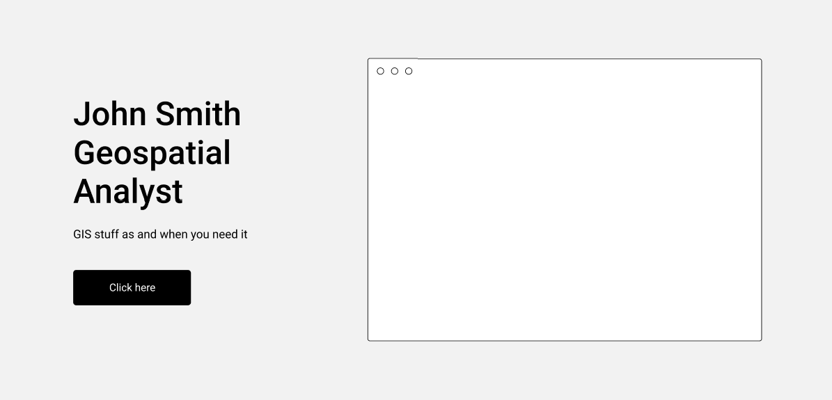
Your personal Value Prop
Job title:
“Geospatial Analyst”
Sure. But what can you do for people?
Can you summarize it in two sentences? If you were a website, what would your hero section be?
John Smith
Geospatial Analyst
GIS stuff as and when you need it.
Click here.
How would people know outside of your department what you do from this?
They’ll know when you tell them
Challenge 2: fill in this template and memorize it. Print a copy and display it at your desk.
Watch people respond to it.
It’s a conversation starter magnet.
I do ………………. for ……………..
(geospatial jargons and phrases the rest of the world doesn’t know are not allowed).
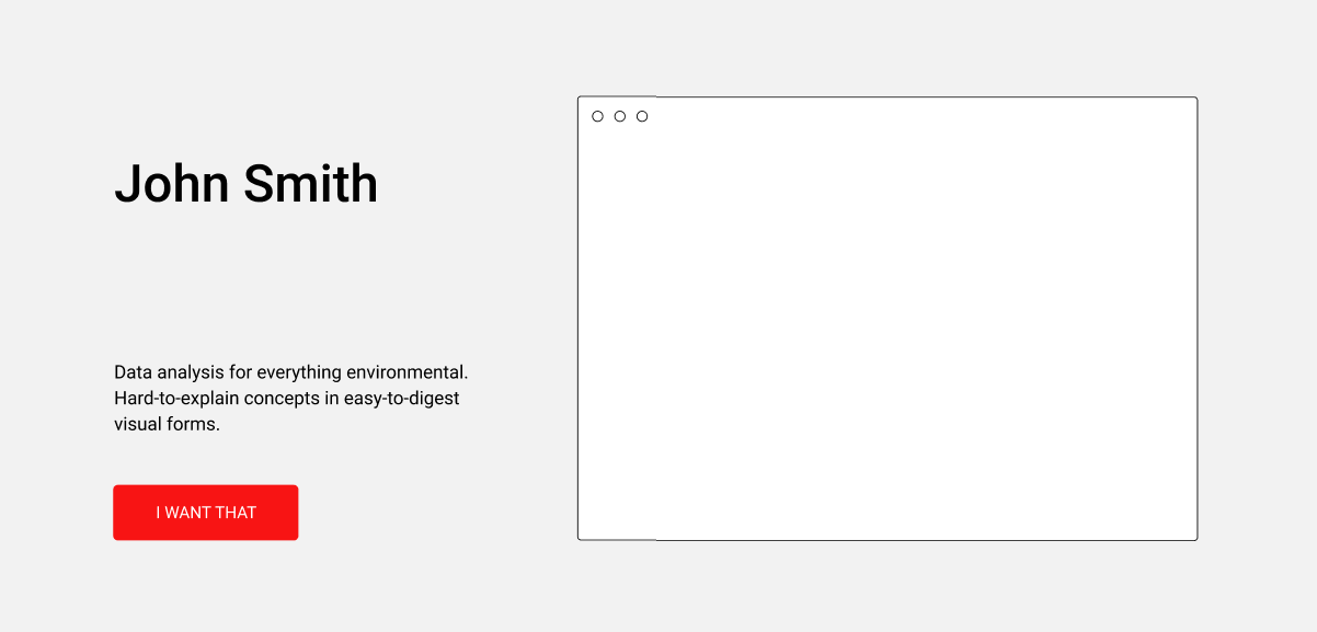
Example…
I analyze data for environmental people who need a visual representation of it.
Good. Can we make it better?
I analyze data for environmental people who need a visual representation of it because it would be hard to explain to people otherwise/that’s the best way for that data set.
Longer, but better. Can we cut it down?
Data analysis for everything environmental. Hard-to-explain concepts in easy-to-digest visual forms.
Totally making this up — but you get my point. You just went from Geospatial Analyst to a concrete thing you can give to people without weighing them down with the how.
Challenge 3: Put this up in your cubicle/workstation and wait for people to ask about why it’s there.
Make it your Zoom background.
Include it in your LinkedIn profile tagline.
Try to fit it into the very next email you write to someone.
Say these words when people ask you at family gatherings what it is you’re doing these days… again?
Bonus challenge: make it visual and use it as your banner on your social media.

What’s next?
When you’re comfortable doing all this, at your next weekly meeting suggest (yes, you!) that you’d like to be featured in the next company newsletter and talk about the department.
Offer to make a five-minute presentation on a passion project you’ve been working on.
Find a charitable organization that needs geospatial help and call upon people to join you.
Keep trying. Put yourself out there and remember, you can’t please everyone. But there will be some that you’ll impress along the way.


#People


Next article

Making our cities more sustainable is one of the biggest challenges that faces humanity in the 21st century; so much so that the United Nations in all its wisdom has identified it as one of the 17 goals for the planet: United Nations Sustainable Development Goal #11 to transform our world – Make cities and human settlements inclusive, safe, resilient and sustainable.
With less than 9 years left to achieve the ambitious goals set out for our cities, 2020-2030 is being touted as the decade of action! As with many things in life, What gets measure gets managed and measuring the transformation of a city towards a more sustainable future is not simple task. How do we use the tools at hand to help local policy makers and city agencies to make their cities more inclusive, safe, resilient and sustainable? To be more precise, how can geospatial data and technology help tackle this challenge?
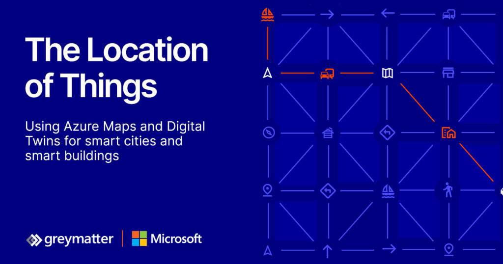
The Location of Things – 14th Geoawesomeness Digital Meetup
We teamed with our friends over at Microsoft Azure, Grey Matter and Evident Proof to deep deeper and talk about the role of Internet Of Things (IoT), Digital Twins and Maps in helping transform our cities and buildings.
You can join us live, listen to 4 amazing talks and network with the rest of the spatial community during the event on 23rd June (registration link).
The WHAT and How of transforming our cities
Digital technologies can transform a city and interconnect key areas of its ecosystem. Although few places in the world have moved beyond pilots or specific initiatives, more cities are beginning to use sensor data, digital twins, automation and control systems for urban planning, visualisation, simulation of the urban environment, connecting citizens to services, and operating city infrastructure through city management dashboards.
Digital Twins
The concept of digital twins – a digital model and representation of real-world environment brought to life with real time data from sensors and other data sources – has entered the realm of smart cities and promises to enable city administrations and urban planners to make better decisions with the help of data integration and visualisation from across the urban space.
Location and Geospatial services
Understanding and operating an environment as complex and interdependent as a city needs a lot of data and maps are a fundamental tool for making sense of that for planning and operations.
Maps can help you understand the data from sensors more easily by seeing them in context; they also turn out to the be a logical way to organise and manage ontologies and hierarchies of smart devices into a smart building.
The role of Microsoft Azure in all of this
Microsoft Azure Digital Twins platform enables modelling and creating digital representations of connected environments like buildings, factories, farms, energy networks, railways, stadiums, and cities, then brings these entities to life with a live execution environment that integrates IoT and other data sources. To drive openness and interoperability, Azure Digital Twins comes with an open modelling language, Digital Twins Definition Language (DTDL), which provides flexibility, ease of use, and integration into the rest of the Azure platform.
Location can also be important in modelling and predictive maintenance for gaining insight and making data-driven decisions. Azure Maps provides mapping and geospatial services including access to real-time traffic, transit planning, route-finding, and weather data that are a key part of the smart city opportunity which is why Microsoft’s Smart City IoT services integrate closely with Azure Maps.
About Geoawesomeness Digital Meetup
The main objective for us at Geoawesomeness to host these meetups is to bring the community together to talk about how geospatial data and tools is transforming the world for the better. Think of these events as an open-source project aimed at enabling conversations and cross-industry cooperation. Each event has at least one speaker from the industry that is using geospatial data and tools to solve problems.
Since the middle of 2020, we hosted 13 events until date and already have plans for many more in 2021 (2021 schedule). More than 5000 GeoGeeks from all over the world attended the events so if you are looking for (virtual) opportunities to network with the geospatial community, the Geoawesomeness Digital Meetup is the place to be!
The event is hosted by Muthu and Aleks. You will find their contact details below.
| https://www.linkedin.com/in/muthukumarkumar | muthu@geoawesomeness.com | |
| https://www.linkedin.com/in/aleksanderbuczkowski/ | aleks@geoawesomeness.com |