
Foursquare has been testing ads for sometime already. Last year the company introduced promoted updates, which operated much like Google AdWords. The sponsored posts would show up when users searched for a place to go, and advertisers would pay Foursquare if users clicked through. But this was not the end. Last months we’ve been reporting that Foursquare started testing their paid ads with a few businesses in NY.
Well it seems that the tests went well… This week 4sq officially launched location-based ads. Are you afraid that they will become a second Facebook, which is pushing ads to the limits? It’s actually not that bad.
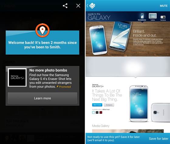
The ads pop up immediately after you check-in to a location similarly to unlocking a special or earning a 4sq badge. On the example above you see that there is nothing scary about it… just a Samsung Galaxy geo targeted ad;). One of the first brands to take advantage of this possibility is Captain Morgan’s rum. You will be targeted with a rum ad when you check-in a bar. If the place participates in the promotion you will receive e.g. 20% off your rum cocktail.
This is actually not that annoying. Let’s just hope that Foursquare will not follow the way of Facebook.

#Business


Next article
NVIDIA Launches World’s First GPU-Accelerated Platform For Geospatial Intelligence Analysts

The world leader in Visual Computing and the inventor of Graphical Processing Unit (GPU) – NVIDIA, is a well-known brand among us the “computer generation” for GPUs that help us visualize and play amazing games on the PC and other platforms.
Now, NVIDIA will also be remembered for being “Geoawesome”. Just days ago, they had announced the launch of the world’s first GPU-accelerated platform for Geospatial Intelligence Analysis. The “NVIDIA GeoInt Accelerator” will offer tools that enable faster processing of high-resolution satellite imagery, facial recognition, combat mission planning using Geographic Information System (GIS) and object recognition using data from drone surveillance.
The GeoInt Accelerator offers a complete solution consisting of an NVIDIA Tesla GPU accelerated system, software applications for geospatial intelligence analysis, and advanced application development libraries.
Remember all the cool image analysis that we witnessed in “The Italian Job” , the facial and object recognition analysis that Russel Crowe utilizes from drone images in the movie “Body of Lies”. This GeoInt accelerator will be able to process such stuff at speeds that will only make the intelligence and defense departments wanting for more.
Really how fast is NVIDIA saying this accelerator is?
The NVIDIA GeoInt Accelerator is the first accelerated platform that enables defense and homeland security analysts to accurately generate actionable intelligence from petabytes of data, images and video gathered from satellites, surveillance cameras, drones, and sensors. By using GPU accelerators, the GeoInt Accelerator analyzes image and video data up to 10 times faster than systems with CPUs alone.
The key applications in the GeoInt platform include the likes of
- Digital Globe – where the intelligence community can process over 3 million sq.km of high resolution satellite imagery for Points of Interest
- GeoWeb 3D – It delivers 3D Fusion information from LIDAR, Remote Sensing and Videos. All this without the need for pre-processing.
- Imagus – real time facial recognition from surveillance data.
- IntuVision Panoptes – object detection and event-driven alerts from real time analsysis of video streams.
- LuciadLightspeed – Overlays image, RADAR, Remote Sensing data for providing situational awareness for mission planning.
- NerVve Technologies – automated object detection in images and videos.
All the information and analysis in the speed that this accelerator can offer! I can imagine sitting in the intelligence office of any technologically advanced country that uses videos from CCTV cameras across the globe to analyze the movement of one specific person or a group that indulge in violence, uses Satellite Images to locate your movement of arms and ammunition in real time.
These are really child’s play with the kind of visual computing power that we have these days and the GeoInt accelerator will help accelerate the widespread use of such technologies.
“Faster Insights for the Geospatial Intelligence Analyst” – for sure!
P.S: I wonder how much one of these GeoInt’s are going to cost… A lot of people would love to have one to speed up their GIS analysis 😉