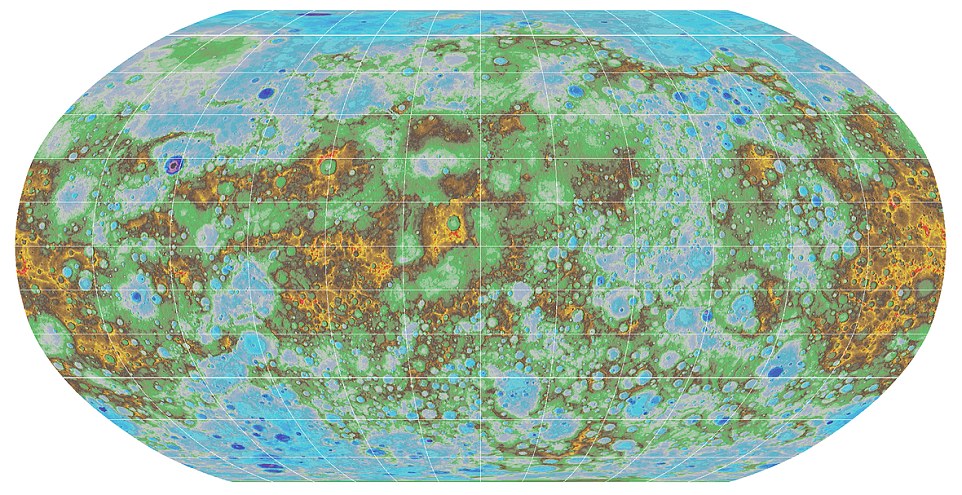
Mercury, the closest planet to our sun, now has an accurate topographic map. But how do you make a map of the whole planet which is 48 million miles (77 million km) away?
The scientists used 100.000 images taken by NASA’s MESSENGER. The spacecraft (which is an acronym for MErcury Surface, Space Environment, GEochemistry and Ranging) launched toward Mercury in 2004 and began orbiting the planet in 2011. Last year it ended its four-year long mission after flying around Mercury 4100 times. It took several months to process the data and place on a graticule (a network of longitude and latitude lines on a map).
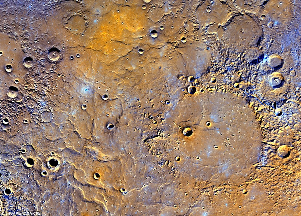
The effect of their work is a high-resolution topographic map that the view of the planet’s entire surface. It shows craters, volcanoes and tectonic landforms among oth. The blues and greens show a lower elevations, while warmer colours show the planet’s volcanoes and mountains.
 Mercury’s lowest point lies in the Rachmaninoff basin, located in the northern hemisphere, and is about 3.34 miles (5.38 km) below the planet’s average elevation. The highest peak on the planet, meanwhile, is located just south of the equator, and is 2.78 miles (4.48km) high.
The map was a collaboration between then U.S. Geological Survey, Arizona State University, Carnegie Institute of Washington, Johns Hopkins University Applied Physics Laboratory and Nasa, and it’s truly amazing.

#


Next article

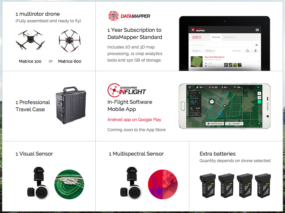
DataMapper is a cloud-based platform for storing and analyzing remote sensing data captured by drones, planes and satellites. The platform has been developed by PrecisionHawk – one of the most influential drone companies out there, which recently raised $18m in series C funding.
Yesterday PrecisionHawk and DJI announced a partnership for agriculture market. It will link DJI’s commercial drone hardware with PrecisionHawk’s DataMapper platform to offer a complete agricultural analytics solution. Michael Perry, DJI’s Director of Strategic Partnerships told us:
“Farmers need real-time information about their crops, their fields and their harvests, and DJI and PrecisionHawk are working together to give them what they need. We are excited to make collecting and analyzing aerial data easier and more cost-effective than ever, because putting this technology within reach of working farmers will help them as well as everyone who relies on the crops they produce.”
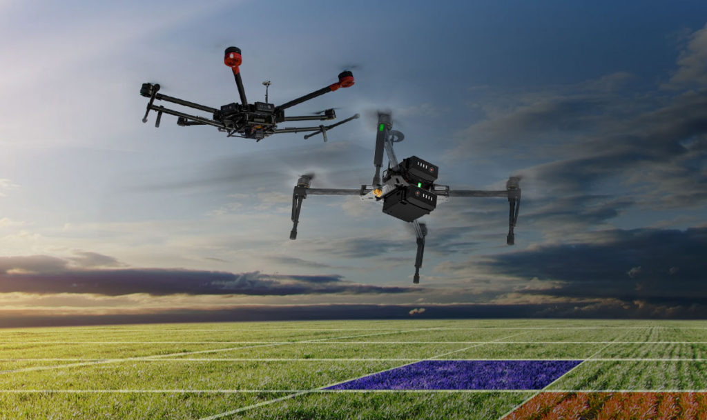
DJI, the company that revolutionized consumer drone’s market with its Phantom quadcopter series is now investing a lot of attention in professional solutions. The company’s UAV platforms that include the Matrice M100 and M600 series are designed to carry advanced sensors needed for crop monitoring. The overall ecosystem will be enhanced with the new DataMapper Inflight app for data collection and management directly in the field.
The app is already available for Android and soon will be realeased for iOS. It allows user to easily create a flight plan for autonomous areal capturing. The images can be viewed and processed via the app. PrecisionHawk offers multiple build-in processing algorithms as well as the algorithm marketplace where you can buy and sell processing scripts.
All the products are available as a bundle deal where farmers will get everything they need to start using UVAs for optimizing inputs, reacting to threats, improving variable rate, increasing efficiency of crop scouting and estimating yiel.