
 ESRI is widely regarded as a GIS powerhouse and is certainly one of the most visible companies in the industry. Recently, ESRI’s founder Jack Dangermond pledged over $1 Billion in mapping software to schools across USA (read more here). A move that will make kids learn about spatial analysis and GIS whilst at the same time promoting ESRI products and it looks like ESRI has taken it’s commitment to spatial education one step further, announcing a new MOOC (Massive Open Online Course) on spatial analysis titled “Going Places with Spatial Analysis”.
The course schedule has not been announced yet but the course is scheduled to be for 6 weeks and you get free access to ArcGIS Online, ESRI’s cloud GIS service.
- Hands-on exercises, short video lectures, quizzes, case studies and discussion
- 6 weeks, 2-3 hours of study per week
- Certificate of completion and prizes
- Next start date announced soon
– See more at: https://web.archive.org/web/20160201091852/http://www.esri.com/landing-pages/training/spatial-analysis
This Massive Open Online Course (MOOC) is for people who know something about data analysis and want to learn about the special capabilities of spatial data analysis. Spatial analysis focuses on location to gain a deeper understanding of data. Spatial analysis skills are in high demand by organizations around the world. You’ll get free access to the full analytical capabilities of ArcGIS Online, Esri’s cloud-based GIS platform. Previous experience with GIS software is helpful, but not necessary for tech-savvy problem solvers. Could you and your career go places with spatial analysis? – ESRI Web Page
How detailed would the course be? Guessing by the previous GIS MOOC by Penn State University “Maps and the Geospatial Revolution”, I wouldn’t be really upbeat about the MOOC especially if you are already a GIS geek 😉 But this is probably a good opportunity for you to experience ArcGIS Online and then compare your experience with Open Source and other WebGIS solutions. Nevertheless, the best part about GIS MOOCs is that now I can forward videos to explain GIS to interested people instead of using GIS jargons 🙂
You can sign up for the “Going Places with Spatial Analysis” here. See at the virtual class then 🙂
The location is anything is becoming everything!


#Business


Next article
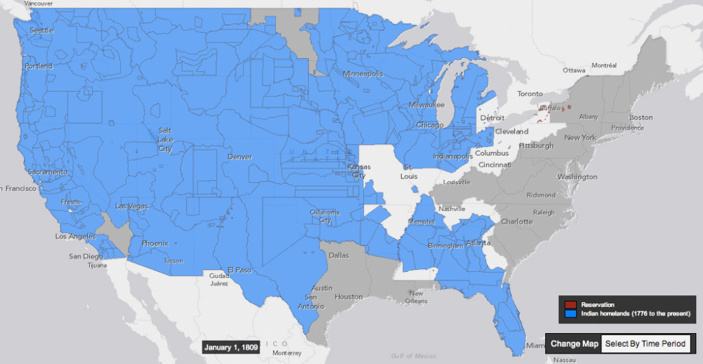
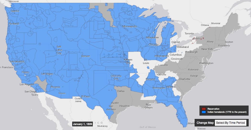
Today I found a very interesting concept of an interactive map which supplements a history book. Claudio Saunt – historian from the University of Georgia has recently published his new book “West of the Revolution: An Uncommon History of 1776” which is a story on what was happening on the American continent in 1776 outside of our traditional line of sight. The problem with maps in ‘analogue’ history books is that they can’t show the dynamic spatial changes throughout the whole century. The ‘time geography’ is very difficult to present in 2 dimensions. This is why Claudio Saunt complemented his book with an interactive web map called The Invasion of America.
The map shows a time-lapse of the transfer of Indian land between 1776 and 1887. As blue “Indian homelands” disappear, small red areas appear, indicating the establishment of reservations. But the time-lapse feature is just a part of the map. User also gets the access to the georeferenced scanned source maps produced in 1899 by the Bureau of American Ethnology. By selecting a source map, and then zooming in to the state you’ve selected, you can see details of the map used to generate that section of the interactive one.
I really like this map and the concept of linking paper books with web maps. Of course one could say that it’s possible to create more impressive user experience with interactive books for tablets but I must say that after reading on Kindle and iPad for a few years, I came back to paper books. I find the old-school, analogue reading experience much more pleasant than the digital one;). I believe that using such a tool to present and teach history is really very effective. At the end the history is not a list of dates and facts but it’s an interaction of people and places in particular moment of time. Historians and cartographers unite!
source: Slate