This Add-in Will Make Your EO Data Workflows in ArcGIS More Effective at Scale

Satellite data represents a critical component of a large number of geospatial analytics use cases, yet many GIS solutions, such as ArcGIS, have not been designed to work with raster data at scale with a corresponding level of efficiency. Typically, these tools allow for effective analysis on a single scene, but the moment that you have a larger EO data set, you need more sophisticated and much more expensive solutions like ArcGIS Image Server.
To get around this and effectively work with satellite data, many users have resorted to working with satellite images outside of ArcGIS and then importing the output data into the system, which is a workable but suboptimal solution. Excitingly, there is a new add-in for ArcGIS that offers the capability for a more effective and efficient workflow.
Working with Satellite Data in ArcGIS
UP42 has always focused its efforts on making life easier for geospatial professionals, and they understand just how important EO data is for geospatial use cases of all kinds. They’ve stepped in here to provide a free integration add-in that pulls the power of UP42 into ArcGIS to streamline the workflow and allow for better management and usage of large raster data sets within the platform. More importantly, the add-in will let users seamlessly buy archive data or task new satellite data for use in the Esri environment.
The Berlin-based start-up offers one of the most comprehensive marketplaces for satellite data from multiple vendors, as well as data processing infrastructure and an algorithm marketplace allowing for a wide range of different practical applications.
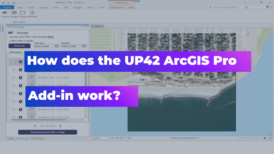
The UP42 ArcGIS Pro Add-in brings all that power into ArcGIS Pro, allowing users to access their UP42 data sets and projects from within their ArcGIS instantiation. This add-in will help to reduce the amount of time it takes to access data, build workflows, and develop geospatial solutions on top of satellite data. Without needing to leave the Esri ArcGIS environment, customers can use the new add-in to access the UP42 platform, where they can open projects that they are already working on, download purchased data sets into ArcGIS itself, and view related metadata.
This goes a long way to extending the usage of ArcGIS and making it more conducive to projects that require large EO data sets in order to generate the desired results. By eliminating this bottleneck, users can now accomplish much more with much less, which is a very positive step for the geospatial community more generally.
How Does the Add-in Work?
You can download and install the free add-in directly from the UP42 website or the Esri marketplace. Once it is installed, you’ll need to copy and paste the Project API Key and the Project ID from your UP42 account into ArcGIS Pro to connect the two.
Once you’ve done that, you’ll have immediate access to your project’s satellite data archives and you can download the required data directly to ArcGIS Pro for analytics. More importantly, you can also process and analyse your data within the UP42 environment, using any of the dozens of available data sources and algorithms in the marketplace, before seamlessly importing those outputs into ArcGIS Pro.
There are some interesting productivity features included in the add-in, e.g. users can create a mosaic of multiple images to easily verify if the available imagery dataset intersects with their AOI.
Moreover, once the imagery has been processed, it can be shared and published using ArcGIS Online, which makes collaborating on the data much more effective.
It’s certainly one of the most efficient and affordable ways to process your EO data in the cloud without needing to invest in the entire Esri imagery suite which is powerful but also very expensive. This solution allows you to leverage an UP42 platform subscription more effectively, giving you the flexibility to effectively work with satellite data in a more affordable way.
You can also now place orders for satellite data through the UP42 catalog directly from ArcGIS within the context of whatever you are working on. This makes the workflow even quicker and easier, which goes a long way toward improving overall project outcomes.
In addition, the value of this integration will compound over time as UP42 continues to work on new geospatial data products, tools, and algorithms. Being able to bring all these directly into ArcGIS Pro allows for more effective workflows, all within the same intuitive interface that they’ve become comfortable with, and without spending a fortune along the way.
If you’d like to read the official documentation which provides some further details, you can find that here. But truly, the best way to get a sense of why this enables such an effective workflow is to download it and try it for yourself. Once you’ve plugged it into your ArcGIS setup, you’ll see how much more efficient you can be by having UP42 access at your fingertips.
Conclusion
In summary, this add-in is one of the most affordable and effective tools for circumnavigating ArcGIS’s limitations in terms of working with EO data at scale, and it opens up a wide array of use cases that would not previously have been possible without investing a significant amount of money into the project. It will significantly reduce the amount of time it takes to access data, build visualisation workflows, and develop geospatial solutions.
This is great news for the geospatial community because making it easier to access and work with satellite imagery at scale is a key building block that can push the industry forward. Reducing this barrier and making these use cases more accessible should help to increase the adoption of satellite imagery across all geospatial applications.
Did you like the article? Read more and subscribe to our monthly newsletter!

#Categories

Next article
The EU’s Regulation on Deforestation-free Products and the Role of Earth Observation

Deforestation is a Major Threat
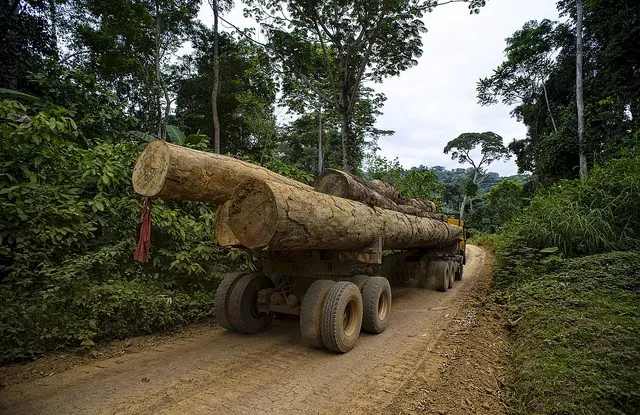
Deforestation and forest degradation is a significant environmental issue that has severe implications for the future of our planet and the livelihoods of millions of people globally. In spite of its damaging effects, it still continues to happen at an alarming rate, aggravating climate change and the loss of biodiversity. In The State of the World’s Forests report published in 2020 by the United Nations, the agency estimates that over 420 million hectares of forest have been lost since 1990. To put that number into perspective, the total forest area is estimated to be 4.06 billion hectares.
The main driver behind deforestation is the expansion of agricultural lands. According to the UN report, 77% of the global deforestation and forest degradation can be attributed to large-scale commercial agriculture (primarily cattle ranching and cultivation of soya beans and oil palms) and local subsistence agriculture.
The world population is set to keep growing in the coming years, only serving to increase the pressure on agriculture. Ironically, loss of biodiversity will severely impact the resilience of our modern industrial agriculture. Saving biodiversity isn’t a matter of protecting nature alone, it’s a matter of protecting human civilization.
The EU Regulation on Deforestation-free Products
The EU regulation on deforestation-free products has been in the works since 2019, and is part of a broader plan of actions to tackle deforestation and forest degradation first outlined in the 2019 Commission Communication on Stepping up EU Action to Protect and Restore the World’s Forests.
The actual regulation is more than 75 pages long. In a nutshell, it aims to:
- Curb deforestation and forest degradation by banning the placement on EU market products linked to deforestation
- Address deforestation and forest degradation caused by agricultural expansion
- Reduce carbon emissions caused by EU consumption and production of the relevant commodities by at least 32 million metric tonnes per year
Indirectly, it also encourages/supports the use of satellite-based positioning (EGNOS/Galileo) and Earth observation satellite data (Copernicus) for due diligence reporting and compliance checks.
The regulation is in the last stages. A political agreement was reached on a joint proposal in December 2022 and it is set to repeal the EU Timber Regulation. Once the regulation is in force, operators and traders will have 18 months to implement the new rules.
What are the requirements?
The regulation specifically tackles deforestation and forest degradation caused by different primary commodities and derived products, i.e.
- Palm oil
- Cocoa
- Soy
- Coffee
- Beef and leather
- Wood
- Furniture
- Rubber
The regulation requires operators and traders to ensure products that they place on EU markets are deforestation-free by:
- Ensuring that the commodities are fully compliant with local laws in the countries of origin
- Providing exact geo-coordinates of where the commodities were produced
- Risk assessment and due diligence reports certifying that the commodities are not originating from land that has been deforested or degraded since December 31, 2020
The regulation applies to all traders operating in the EU regardless of their size. However, large traders are subject to monitoring measures listed in Article 15 of the regulation, while SMEs are subject to the measures listed in Article 16.
What Does the EU Regulation on Deforestation-free Products Mean for Earth Observation?
In a huge boost for the Earth observation industry, policy makers have explicitly foreseen different areas where satellite data could help to ensure that objectives are met. EU policy makers in their wisdom have mentioned “Earth observation”explicitly thrice in the regulation text, in the following context.
- Satellite-based positioning (EGNOS/Galileo) and Earth observation data (Copernicus) could be used for risk assessment and compliance checks by operators
- Earth observation data (Copernicus) as a facultative measure by competent authorities as a check on the operators
However, that is only part of the story. In my opinion, Earth observation will play a key role in the following ways:
Creating a global benchmark
A critical input to the monitoring process/control measures envisioned in the regulation is a global map of forested areas, deforested areas and areas where forests are degraded as of 31st December 2020. In addition, the EU also needs to define and designate countries and sub-national regions as high, standard or low-risk areas based on the local anti-deforestation laws and their efforts to tackle illegal land use.
In both of these cases, Earth observation is the solution. It sounds like a straightforward answer but the huge advantage that Earth observation brings to the table is only felt when we consider the alternative – an information system that contains up-to-date land records and land use data for every country in the world. For many years now, organizations across the world have been using satellite imagery to create benchmarks for deforestation. In fact, since its launch in 2014, Global Forest Watch has been visited by millions of people from every single country in the world.
Geo-traceability of Products and Supply Chain Transparency
The regulation requires companies to implement due diligence systems that trace the origin of their products and ensure they are sourced from deforestation-free areas. This is the first area where EU policy makers directly identified and supported/encouraged the use of Earth observation and satellite-based positioning (GPS/GNSS).
Satellite data analytics can help track land-use changes, such as the conversion of forest areas to agricultural land providing evidence of deforestation or degradation. This information combined together with geo-tagged commodity data can be used to create a comprehensive picture of product origins and compliance with the regulation.
Demonstrating progress
Whilst demonstrating progress towards sustainability commitments that operators make isn’t part of the regulation, creating supply-chain transparency can be a huge positive force also with consumers.
Large-scale commercial agriculture companies can publish their supply-chain records publicly and make it available for independent organizations to verify them to create an advantage with markets and consumers.
Check on operators
The regulation requires operators to produce proof that their products are deforestation-free whilst also laying down the obligation of competent authorities with regard to checks to be carried out on operators. This is the second area where EU policy makers directly identified and supported/encouraged the use of Earth observation (Copernicus).
The use of Earth observation data is stated as a facultative measure by competent authorities as a check on the operators.
EU member states could develop a unified satellite-based change monitoring system similar to what Global Forest Watch does today to monitor the global deforestation situation. Earth observation is particularly important when dealing with complex supply chains that span multiple countries and legal jurisdictions by providing robust and unbiased information. Earth observation data is universally accessible and not limited by national boundaries.
Regular reports generated by such a system can be used to identify non-compliance, and serve as evidence when appropriate enforcement actions must be taken.
Evaluating the overall impact of the regulation on deforestation
The regulation is only a success if it ensures deforestation is halted or at least minimized. By analyzing global forest cover over time, the impact of the regulation on deforestation rates can be accessed, serving as an input to inform future policy decisions and refine the regulation to better address deforestation and forest degradation.
Benefits of the regulation
The EU is the second largest driver of tropical deforestation. It is estimated that EU consumption represents around 10 % of global deforestation. Any efforts that limit or eliminate further deforestation due to EU consumption is going to be a huge boost to biodiversity. Further benefits of the regulation include:
- Contributions to the global efforts to mitigate climate change
- Helping the EU achieve its climate targets under the European Green Deal
- Helping promote responsible land management in countries that export to EU
- Ensuring supply chains are sustainable and transparent
- Driving adoption of Earth observation and fostering public awareness about the positive benefits of satellite imagery
Challenges ahead
The EU regulation on deforestation-free products is similar to GDPR in the sense that it’s the first regulation in the world and there will be many challenges ahead before the regulation is properly understood and implemented. There remain several challenges ahead that need to be addressed to ensure its long-term success and effectiveness:
A tsunami of false alerts
Arjen vrielink, co-founder of Satelligence, coined the term ‘a tsunami of false alerts’ to highlight the challenges facing national authorities. Given the fact that Earth observation data is publicly available but there is no standardization for satellite data analytics, it is quite possible that different organizations may arrive at different conclusions regarding whether compliance was achieved. This is a challenge that is entirely up to the Earth observation expert community to solve.
27 or 1?
In our understanding, it is the responsibility of the 27 member nations to define their own processes for checking on operators based on Article 15 and 16 of the regulation. Enforcing the regulation across complex and global supply chains can be challenging, particularly in regions with weak governance or limited resources. Ensuring consistent implementation and enforcement across all member states and industries is crucial to achieving the regulation’s objectives.
Ensuring the small guy doesn’t lose out
Many smallholder farmers and local communities depend on forests for their livelihoods, and shifting to sustainable practices can be economically challenging for them. Providing support and incentives to help these stakeholders transition to sustainable land management practices is vital to the success of the regulation. This was one of the key messages also delivered by Stefano Savi.
What about other drivers of deforestation?
While the regulation targets key commodities linked to deforestation, it doesn’t include all agricultural commodities (such as biofuels) nor does it address other factors that contribute to forest loss. Tackling these underlying causes of deforestation requires integrated and comprehensive policies that go beyond regulating specific commodities.
The EU is already contemplating expanding the regulation to address some of these aspects a few years afterwards.
Geopolitics
More than half of the world’s forests are found in only five countries (Brazil, Canada, China, Russian Federation and the United States of America). Relations between the transatlantic partners were stressed due to GDPR and here again the effectiveness of the EU regulation on deforestation-free products depends on cooperation with countries that produce and export the targeted commodities. Engaging with these countries and promoting sustainable land management practices can help improve the global impact of the regulation. The Commission has already pledged € 1 billion to facilitate protection, restoration and sustainable management of forests in the partner countries, for the benefit of people, climate and environment.
A Leading Role in Ensuring the Success of the EU Regulation on Deforestation-free Products
The EU regulation on deforestation-free products is a groundbreaking and significant first step in the global fight against deforestation and forest degradation. US lawmakers are looking to follow in the footsteps of the EU. Hopefully more countries will follow as well. By targeting some of the key commodities behind global deforestation activities, the regulation has significant potential to tackle deforestation and the loss of biodiversity.
At Geoawesomeness, we are always repeating that we are driven by the power of geospatial data and tools to transform the world for the better. The EU regulation and the vital role that Earth observation plays in supporting the EU regulation on deforestation-free products is yet another proof of that transformative power. Through monitoring, traceability, compliance verification, and evaluation, Earth observation technology provides essential data and insights that help ensure the effectiveness of the regulation in preserving forests and combating deforestation.
Despite the challenges that lie ahead, such as implementation, enforcement, addressing indirect drivers of deforestation, and supporting smallholder farmers, continued collaboration and commitment from various stakeholders will be crucial in overcoming these obstacles. By addressing these challenges and refining the regulation as needed using inputs from Earth observation, the EU can play a leading role in promoting deforestation-free products and safeguarding the world’s precious forest ecosystems for future generations.
Did you like the article? Read more and subscribe to our monthly newsletter!