The New Elevation Product From Airbus is Set to Offer DEM with 0.5m Resolution

The geospatial community has been buoyed by continual improvements in the quality of satellite data which allows users to look at the world from a completely different perspective. The accelerated innovation has opened the doors for very high-resolution data that unlocks a whole new range of new applications. A great example is the new Pléiades Neo data from Airbus that we’ve covered previously here on the blog.
This type of high-resolution satellite imagery allows us to not only have a 2D view of the entire globe, but it also allows us to piece together multiple images to create sophisticated 3D models using the principles of photogrammetry.
Introducing DEM Airbus
Airbus’ Elevation Portfolio offers a large range of Elevation products from global off-the-shelf to local and on demand availability.
The so called WorldDEMTM, elevation models are based on Airbus radar satellites, TerraSAR-X and TanDEM-X. The WorldDEM products are fully functional off-the-shelf datasets covering the entire surface of the Earth, from pole-to-pole, in different resolutions up to 5m posting with WorldDEM Neo.
The on-demand Elevation products are created to use the wide range of Airbus satellite optical systems including Pléiades and Pléiades Neo. Therefore these products are at a much higher resolution and they are only purchased as and when needed – to take advantage of the most updated data possible. Up until now the on-demand Elevation data had three products based on Pleiades 50cm imagery– Elevation1 & 4 (with 1m and 4m resolution) and a 3D textured Model (3D mesh model with realistic fascades).
However, the company has now developed an exciting new 50cm resolution elevation product from Pléiades Neo which is set to transform the state of the industry once again.
Launching Elevation 0.5
Thanks to the launch of new Pléiades Neo 30cm optical satellites, Airbus is now in a position to offer 50cm resolution elevation models to users. This is the result of extensive R&D work that pushed the resolution and accuracy to an industry-leading standard that is unmatched by any other satellite data provider.
Comprehensive testing allowed the team to calibrate and validate the final resolution to 50cm and the relative accuracy to a level of 1m. The absolute accuracy is between 3m and 5m – thanks to a worldwide Airbus own reference database – but this can be further improved when a customer provides Airbus with additional ground control points, which may take it even under the 1m resolution threshold.
It’s worth noting though, that accuracy is not the be-all and end-all. In addition to this, the new 50cm elevation product offers exceptional 3D photorealistic quality. Objects such as trees and buildings are represented in a way that the industry simply hasn’t seen before – thanks to the leverage created on Airbus’ proprietary photogrammetric production process and algorithms.
After some tests run by early adopters, Airbus is ready to release Elevation 0.5 model to the market very soon.
How Does It Work?
Creating a digital elevation model of this kind requires multiple high-resolution satellite images that can then be combined using the principles of photogrammetry. It starts with measuring the conjugate points in your images which are then associated with ground control points to achieve the matching that you need. Then photogrammetry helps to solve for the 3D geo-referencing which can then create the model and visualization that you’re after.
To understand how Airbus’ production process works specifically, we spoke to the Head of Imagery Production at Airbus: Jean-Charles Pruvost. He explains that the process starts by defining the area of interest. Once this is determined, Airbus will check the topography and environment in that specific area so that the parameters can be correctly configured for the tasking team.
After this has been completed, the tasking team will take the necessary stereo or tri stereo images – typically being limited to 10-15 degrees if you’re looking at dense urban areas.
The duration of this part of the process – the editing step – is directly related to the size of the area of interest. A single Pléiades Neo image has up to a 14 km width, which is already huge, but it is possible to combine several images to cover very large areas!
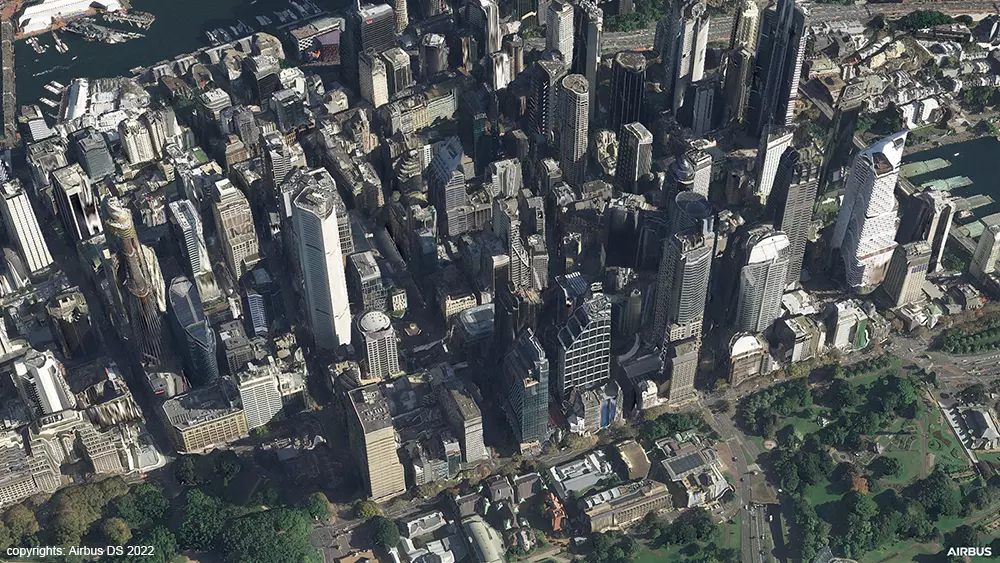
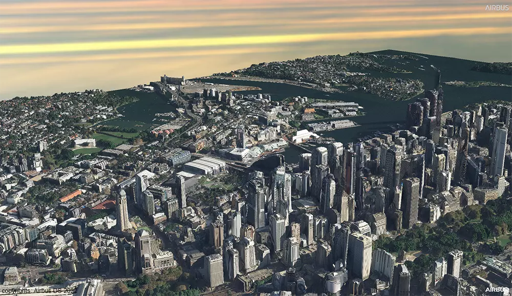
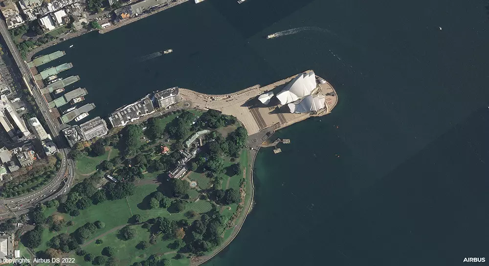
Airbus engineers will then adjust the images to reduce noise and ensure that the resulting 3D models are fair representations compared to the specification provided. Some of the samples that we’ve seen of these are simply astonishing. You can zoom in to roofs, buildings, and street furniture – to see a level of detail that is mind blowing.
copyrights: Airbus DS 2022
Applications and Use Cases
There is a range of exciting use cases that become possible with this level of resolution. While the focus of these models tends to be on digital terrain modelling and 3D visualizations, there are natural extensions, for instance, for the gaming and the defence industries. Some of these applications include:
- High precision weapon targeting and mission preparation in the military context.
- 3D stickers can be placed around airports and bases to handle low-altitude flights and other such considerations.
- Digital Twin visualizations to simulate plants, mining areas, and other Smart City concepts.
- Nuanced public visualizations to enhance wireless network projects, public transport implementations, and more.
- Analysis of solar energy potential on rooftops.
- Creating climate zone maps of urban areas, including urban heat islands and land use maps.
- Replacing the need for drone or aerial data in the mining industry.
- Monitoring the power grid or other similar assets over large areas.
- Improving farm management.
- Progress monitoring for the construction sector.
The applications here are vast and varied and as Jean-Charles Pruvost says: “It looks like a real game changer for the industry.” But as with many new technological breakthroughs, we’ll only truly understand the impact once users can experiment and push the boundaries of what is possible.
Conclusion
Elevation 0.5 represents an inflexion point for the satellite data industry, bringing a level of accuracy and photorealism that we have never seen before. It remains to be seen how this new technology will be utilized – but what is clear is that it opens doors to analyses and modelling capabilities that can transform the way we think about our world.
There is yet to be determined how pricing and product specifications will play out in the marketplace, but for those select clients who are currently in talks with Airbus – we look forward to seeing what is possible with a resolution of under one meter.

#Data source

Next article
How to create a reliable forest inventory using Earth Observation data

Editor’s note: This article was written as part of EO Hub – a journalistic collaboration between UP42 and Geoawesomeness. Created for policymakers, decision-makers, geospatial experts and enthusiasts alike, EO Hub is a key resource for anyone trying to understand how Earth observation is transforming our world. Read more about EO Hub here.
Forests are an essential part of our planet, without which life on Earth would not exist. They are responsible for filtering the water we drink, purifying the air we breathe, preventing erosion, and importantly, slowing climate change. They provide people with critical natural resources from wood to food and shelter for animals around the world.
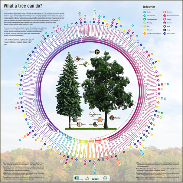
What a tree can do (Source: CEPI)
The forestry industry is a very important contributor to the national economies of many countries. It provides a multitude of different products including food, fuel, construction materials, medicines and raw materials for further processing. One of the main challenges in forest management is resource sustainability. In 1992, as a result of the UN’s introduction of the Forest Principles at the Conference on Environment and Development in Rio de Janeiro, many companies made changes to their forest management practices. The document called on member countries to promote forestry practices that “meet the social, economic, ecological, cultural and spiritual needs of present and future generations.” Forest companies are facing increasing risks, which can be effectively minimized by ensuring forest biodiversity, facilitating healthy ecosystems, and maintaining and preserving clean soil and water resources. The main threats caused by environmental change include:
– Wildfires
Climate change, land use and land management are affecting the occurrence and severity of wildland fires in many parts of the world.
– Insect Outbreaks
An increase in the frequency and severity of insect outbreaks is leading to the loss of significant forest areas around the world.
– Extreme events
A consequence of climate change is extreme events, which include increasingly frequent extreme winds. It is this, combined with drought, that leads to severe weakening of some tree species, which are then attacked by harmful insects and mold, and die completely.
Overview of core technologies
Traditional management and monitoring of large forests are both time-consuming, labor-intensive and expensive. That’s why new technologies for forest analysis, such as satellites and LIDAR, have begun to be used in recent years. The data acquired using these methods are different, but both technologies offer valuable new data not previously available to forest owners.
LiDAR uses laser light to survey the earth’s surface. The main advantage of this technology is its ability to penetrate the tree canopy, and map individual trees and the ground beneath them. In addition, it can provide highly detailed and accurate results. However, LiDAR has some key drawbacks. The data collection is typically done using airborne technologies, which are labor-intensive and use specialized equipment and aircraft, and also very expensive. Therefore, data updates are infrequent and sometimes take up to several years, potentially resulting in data that may be outdated.
Satellites, on the other hand, provide optical as well as radar data on the characteristics of entire forests. The data refresh rates are much higher compared to LiDAR. Such efficient monitoring allows for a much faster response to events, and also for temporal analysis – monitoring changes over time. The data is, however, mainly limited to what is visible on the top of the forest canopy. Forestry companies are seeing advantages of combining optical and radar data in a wide range of applications, which allows them to observe the effects of extreme weather events and fires, and also time to resolve tree health problems.
To effectively plan and manage forests, there is a need for solutions that provide detailed information on the topics mentioned above. “Access to highly accurate estimates of forest stand structure and composition is fundamental to ensure forest managers can plan and manage forest landscapes sustainably over time and space,” said Bruce MacArthur, President and CEO of remote sensing and forestry industry leader at Tesera in an interview with UP42.
Forestry use cases
Forest inventories enable forest owners and managers to operate and plan in a sustainable and profitable manner. Investment in silviculture requires reliable stand-level data to optimize and maximize growth and, over time, value. Emerging services such as ecosystem services, mitigation banking, and carbon sequestration require high-resolution information to inventory forests, support conservation efforts, and contribute to sustainable development. “There is a need for higher resolution forest inventory data and easier to use forestry solutions which is why we created our suite of High-Resolution Inventory Solutions (HRIS) to help move the forestry industry forward” says Bruce.
Satellites in geostationary orbit provide imaging of fires every 5 to 15 minutes. The equipment records the full impact of fires, from quickly detecting actively burning fires, to tracking smoke transport, providing information for fire management, and mapping the extent of ecosystem changes. Changes can be mapped days, and even decades, after a fire. In addition, locations of new fire outbreaks can be sent directly to land managers around the world.
Typically, foresters must obtain each piece of information from a separate source. That’s why intermediary data companies work well in this case. One of these platforms is UP42, which has started a partnership with Tesera. The partnership will allow forestry customers to quickly and comprehensively acquire specialized data from a single platform: “We have found that satellite data and other remote sensing and geospatial data are really spread out across a number of providers and platforms, all with different degrees of difficulty to obtain and stream into analytics processes. What we really like about what UP42 has done is putting these big datasets into one place with common building blocks to interface with the data for our use cases.” – says Bruce
Another challenge for forestry is related to parasites, particularly the bark beetle, which is a plague on trees in continental regions. Some of the most popular indicators for controlling this pest are the Normalized Differential Vegetation Index (NDVI) and the Moisture Difference Index (EWDI). With these, foresters can easily determine the area where diseased or dead trees are present. To enable quick and efficient forest management, applications with algorithms for automatic classification of forest areas are increasingly being developed to support the forest industry in tasks such as tree inventory. The data is automatically analyzed by the system, and a report then provides information, for example, on the number of trees and their parameters in a selected area.
However, earth observation data is not just about satellites and aircraft. Drones are increasingly being used to acquire highly accurate data. These, combined with artificial intelligence, enable appropriate measures to be taken to protect forests by inventorying them, detecting pests, determining the condition of trees and calculating the areas affected by natural disasters. Thanks to the use of such technology, it is possible to collect data from the hardest-to-reach places.
Earth observation data are also an invaluable aid in high winds. An analysis of forest damage was carried out by Piotr Wężyk from the University of Agriculture in Krakow after the hurricane that took place in the Piska Forest in 2006. The mapping of damaged stands consisted of developing CIR aerial photos and interpreting the damage. The thematic maps that were created were then used to conduct GIS spatial analysis to determine the extent of the damage. Thanks to the continuous development of technology, we no longer have to do all the work separately. The UP42 platform features the Land Lines application, in which an algorithm scans remote sensing images for natural loss. With such platforms providing comprehensive data, forest management using new technologies is available to anyone interested.
“Land Lines application” (Source: TESERA)
Conclusions
The forestry industry, despite numerous threats, has the opportunity to draw the best possible data needed for forest inventories. Thanks to advances in technology, these opportunities are available to all interested customers. As Bruce MacArthur summarized on The Digital Forester podcast: “The quantum change that happened is the fact that people now can use these technologies in innovative ways that were previously limited to top researchers, but now with advanced computing, cloud processing, machine learning and remote sensing, it enables companies to be able to take advantage of them in unique ways that help our clients in ways that were not possible previously.”
Did you like the article? Read more and subscribe to our monthly newsletter!