


Much research has suggested that night-time lights can, to a certain degree, represent several variables, including urbanisation, density, and economic growth.
To speed up research efforts and applications, the World Bank released open access, analysis-ready, nightlight data set under Amazon Web Services (AWS) open public data set program.
The Light Every Night (LEN) data set includes the complete archive of all nighttime imagery captured each night over the last three decades. It results from a collaboration between the World Bank, NOAA, and the University of Michigan.
The dataset comprises:
- Defense Meteorological Satellite Program Operational Line-Scan System (DMSP-OLS) data from 1992 to 2017
- Visible Infrared Imaging Radiometer Suite Day/Night Band (VIIRS-DNB) data from 2012 to 2020
Analysis new nighttime light data, new possibilities

Previously, getting data from a specific night or set of nights meant:
- Downloading the images from NOAA archives to a local disk
- Manipulating the images with either GIS/Remote Sensing software or image viewing software like Photoshop or Gimp
Unfortunately, because the dataset volume is large, their useability is reduced.
The LEN dataset and tools eliminate this challenge.
Availability on AWS makes the global nighttime images widely accessible. Further, data processing can be done in-place on the cloud, enabling analysis of vast amounts of data leading to new insights and applications.
In fact, the data has already been useful to various World Bank studies, including monitoring the impact of the pandemic on various human activities.
Apart from the LEN dataset, the World Bank has also provided tutorials on nighttime light data processing, analysis, and applications.
Are you using nighttime lights data? Tell us about it below.
Did you like the article about nighttime light data? Read more and subscribe to our monthly newsletter!

#


Next article

Today, if you want to leverage geospatial data for an application, there is no dearth of online marketplaces offering affordable, pay-as-you-go analysis of open-source spatial data and commercial satellite imagery alike.
However, there is one dataset that plays a crucial role in global defense programs, wildlife protection, maritime applications, and emergency management, and yet, there is no easy way to monitor, locate, visualize, or analyze it in a cost-effective manner.
This data is found in the radio frequency (RF) portion of the electromagnetic spectrum.
For the longest time, radio signals were available only in the form of highly classified datasets, which meant nobody outside the state intelligence communities could be privy to them. But with the RF spectrum finding utilization in everything from consumer goods like cellphones to deep-sea shipping vessels, the demand for unclassified RF data has increased across commercial and humanitarian sectors too.
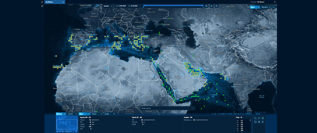
And this is why Virginia-based geospatial analytics company HawkEye 360 has launched Mission Space, a first-of-its-kind commercial platform built to facilitate the analysis of RF data for geospatial intelligence (GEOINT) missions.
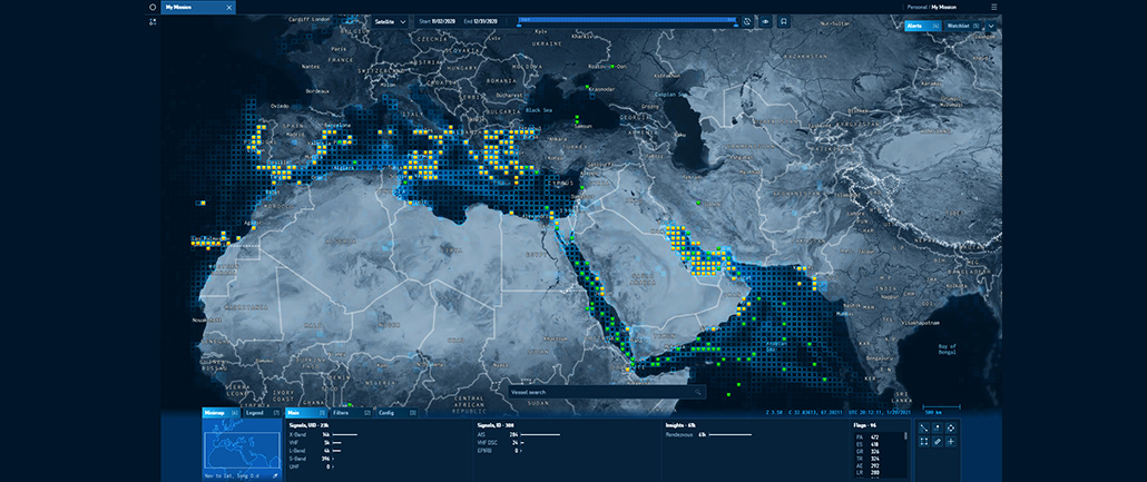
HawkEye 360 Mission Space RF Analysis Platform
By automating the ingestion and visualization of RF signal data and analytics, Mission Space allows analysts to intuitively manipulate and explore all available spatial information within one frame of view. Analysts can see trends and patterns and grab in-depth detail about RF signals, all while maintaining a summary of RF activity for context.
For example, while identifying RF activity in a designated maritime area of interest, not only will Mission Space pinpoint a shipping vessel’s specific RF geolocations, but the platform would also show you its identity, history, past sanction violations, and any identified behavior patterns.
Interestingly, HawkEye 360 uses its own constellation of small satellites to gather commercial RF data and improve the geospatial intelligence. And the company foresees its data supporting a variety of GEOINT applications, such as tipping and cueing of other data sources to include electro-optical and radar imaging satellites.
For Alex Fox, Executive Vice President, HawkEye 360, Mission Space is no less than a “breakthrough for commercial RF mapping” and is unrivaled in the commercial sector. “The platform will empower our customers to efficiently extract immense value from our RF signal subscription services. It will accelerate user adoption of commercial RF analytics across the global defense, intelligence, commercial and humanitarian sectors.”
As John Serafini, HawkEye 360 CEO, puts it, “Visible imaging was once only the domain of governments, until the first commercial imaging satellites were launched. Now look at all the value we’ve gained from commercial images. The emergence of small satellite technology and the lower cost of launch have made it feasible for HawkEye 360 to develop high-capability satellites that are able to generate valuable geospatial insights from RF signals.”
Did you like the article? Read more and subscribe to our monthly newsletter!