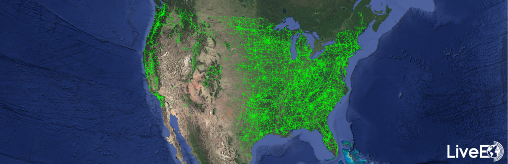
Recently, the Berlin-based space company LiveEO published the results of an amazing study: They analysed the entire U.S. electrical transmission grid based on satellite data to detect vegetation encroachment from space. The results reveal exciting insights about the vegetation condition alongside nearly 574,000 miles of overhead lines.
Besides the sole detection of vegetation, the study aimed to identify regions with a higher-than-average vegetation exposure and lays the baseline for high-resolution analysis of these areas.
Vegetation management is one of the biggest challenges and operational cost factors for utility companies in maintaining their assets, causing up to 56% of externally triggered power interruptions. In the United States alone, approximately US$6 billion is spent on vegetation maintenance by utility companies annually.
LiveEO’s extraordinary analysis is based on publicly available geospatial data from the U.S. transmission network and imagery from the Sentinel-2 mission from the Copernicus program of the European Commission and the European Space Agency. In total, LiveEO evaluated the area around 573,323 miles of power lines based on space-borne data processed on servers in the United States to determine the length of power lines threatened by vegetation. More than 1.7 million square miles (~45% of the total continental U.S. area) of imagery have been processed by LiveEO, equivalent to approximately 15,000 scenes of satellite imagery.
“The scale combined with the detail of the analysis represents a milestone in satellite data analytics for utility companies and proves that satellite data represents a viable alternative for vegetation management to Lidar or foot patrols.” says LiveEO Co-Founder Daniel Seidel. “Additionally, these insights can be made actionable directly via our toolset of mobile and web apps, and API integrations to improve workforce efficiency in the field and to realize OPEX saving.” adds LiveEO Co-Founder Sven Przywarra.
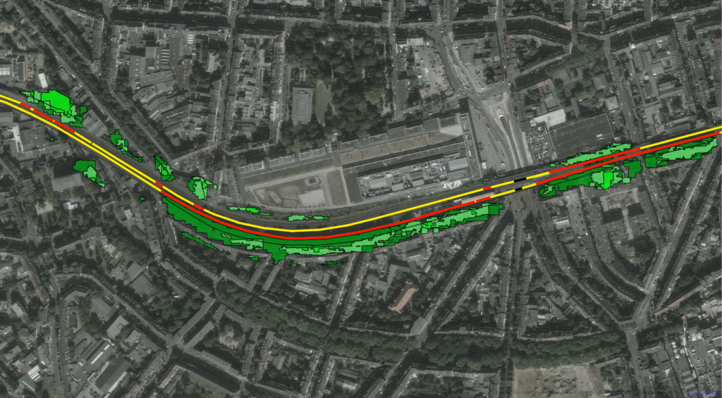
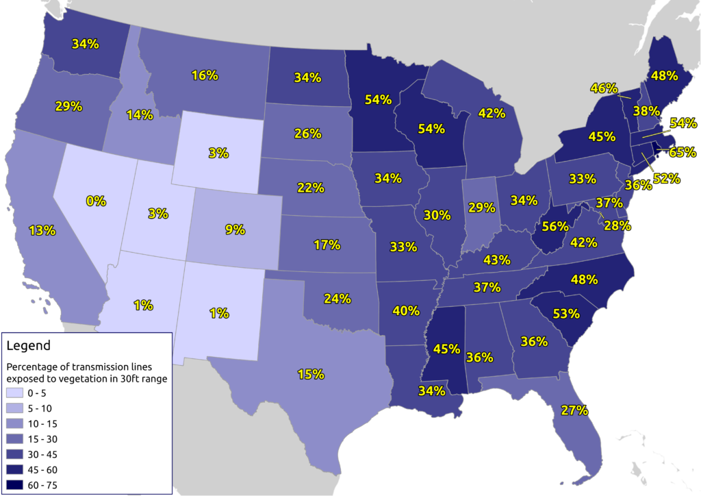
LiveEO found that a total of roughly 50% of the United States transmission network, equalling 291,000 miles, is exposed to vegetation closer than 90 feet. More specifically, they identified 166,000 miles that contained vegetation in a 30 ft. vicinity.
With this study’s help, utility companies get an initial overview of the vegetation condition alongside their assets. In addition to this large scale analysis LiveEO is highly experienced in the extremely accurate and efficient investigation of vegetation height, condition, and species detection alongside electrical transmission and distribution lines, railways and other infrastructure grids:
Height and health of vegetation for example improve the risk assessment of vegetation near overhead power lines enabling an extended cycle trimming that takes into account how tall the trees and shrubs are, whether they are healthy or diseased, and also at what distance they grow from the grid. It also allows hazard trees to be correctly identified and removed, helping in storm and hurricane safety.
Overall LiveEO’s solution allows utilities to improve their UVM (utility vegetation management process) to increase grid reliability, safety and to save up to 35% of operational vegetation management cost.
Another use case for satellite-based vegetation analysis is the identification of fire-prone areas near power lines. In addition to dry conditions and exceptional heat, growing near power lines cause wildfires.
LiveEO is already helping utilities identify fire-prone areas and conduct highly accurate post-wildfire inspections for rapid restoration activities.
With a wide range of utility and infrastructure customers in North America, Europe, and Australia, LiveEO has demonstrated its capabilities in numerous pilot projects and large-scale deployments on an entire countries’ scale.
To strengthen contact with its customers through physical presence, LiveEO opened an office branch on the East Coast of the U.S. in late 2020.
More information about LiveEO’s analysis can be found on their website. LiveEO offers infrastructure customers a free sample analysis of their network.
Did you like the article? Read more and subscribe to our monthly newsletter!

#


Next article


Screenshot of the report cover
A report published by the World Economic Forum (WEF) in collaboration with Digital Earth (DE) Africa explores the potential economic impact of Earth Observation (EO) data in Africa.
Published on January 15th, the report predicts that the impact of DE Africa could surpass $2 billion per year by 2024. It mentions three key areas that will benefit from the information provided by DE Africa: the EO industry, the agricultural sector, and the mining industry.
Here are 3 takeaways from the report.
1. Countries still face challenges of Earth Observation (EO) data availability, quality, and useability preventing them from utilizing its full potential
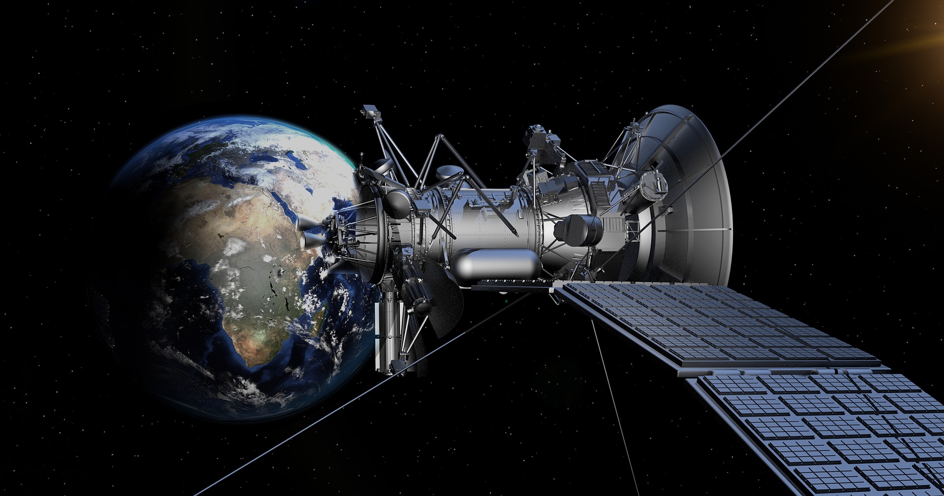
Image by PIRO4D from Pixabay
The lack of actionable data and information on key trends is hampering the progress of new technologies to tackle issues facing Africa.
According to a 2017 report, the adoption of EO globally can contribute to the attainment of 16 Sustainable Development Goals (SDGs).
Specifically, using EO within Africa is directly relevant to the attainment of:
- Zero hunger – SDG 2
- Clean water and sanitation – SDG 6
- Industry, innovation, and infrastructure – SDG 9
- Sustainable cities and communities – SDG 11
- Climate action – SDG 13
- Life below water – SDG 14
- Life on land – SDG 15
Consequently, if EO data were easier to access and use across the continent, countries could overcome several challenges in meeting the needs of their growing populations.
2. DE Africa can ease access to EO data
The Open Data Cube (ODC) is a non-profit, open-source project that provides an innovative and freely accessible solution. It makes it easier to use satellite data to its full potential by:
- Streamlining data distribution management for providers
- Lowering technical barriers for users
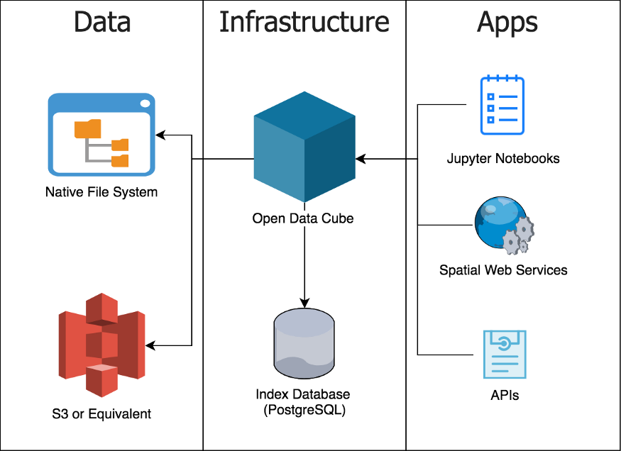
A simple diagram of what makes up an ODC deployment (Source)
Digital Earth Africa, formerly Africa Regional Data Cube, has scaled up ODC technology to the entire African continent.
It is translating EO data into information and services and, as a result, increasing its useability.
In fact, it will be the world’s largest open data cube providing insights into various issues including flooding, droughts, soils, coastal erosion, agriculture, forests and land use land change, water availability and quality, and changes to human settlements.
Leveraging from the lessons and achievements of DE Australia, and the Africa Regional Data Cube, DE Africa will certainly shape the growth of all sectors across the continent.
3. Realisation of the full benefits of EO data depends on the development and adoption of geospatial industry best practices
Photo by Donald Giannatti on Unsplash
The report estimates that DE Africa will speed up the growth of Africa’s EO industry by $500 million a year from 2024. (Estimated from GeoBuiz – Geospatial Industry Outlook & Readiness Index, 2018 and 2019)
The estimate assumes that:
- DE Africa will raise the quality of African Data Infrastructure (i.e., availability of EO images in the region), by halving the distance between Africa and Australia (where a similar project is in full force) by 2024.
- DE Africa could stimulate African countries to improve other policy-related indicators. That by 2024 Africa will reproduce the best practices adopted in different areas by the top-performing countries.
Therefore, to unlock the full potential of EO data, countries should adopt the following best practices:
- Have a national geospatial data infrastructure.
- Have an enabling national geospatial policy framework (inclusive of data dissemination and data access). The framework will support the implementation of National Spatial Data Infrastructure, surveying and mapping policies, open data policies for geospatial data and otherwise, and Space policies.
- Build and invest in institutions offering distinctive courses for higher education and research. This will develop a highly knowledgeable and talented pool of human resources for overall user adoption, industry and entrepreneurship, and innovation advancement.
- Have capabilities to integrate geospatial information with applications/hardware and software of varied ecosystems such as IT and Engineering. This will lead to the creation of unique solutions, generating substantial economic and social value.
- Have a vibrant geospatial industry ecosystem. Countries should have dedicated geospatial technology business incubation programs as part of national programs. Additionally, they should have well-diversified representative industry bodies, professional member networks, and institutions. Further, they need a diverse spread of products, services, and solutions categories for various geospatial technology domains.
Eventually, even though DE Africa will improve the geospatial data infrastructure on the continent, in order to unlock the full potential of EO, the African ecosystem of industry sectors and government institutions need to develop the remaining best practices.
Read the full report and share your thoughts with us.