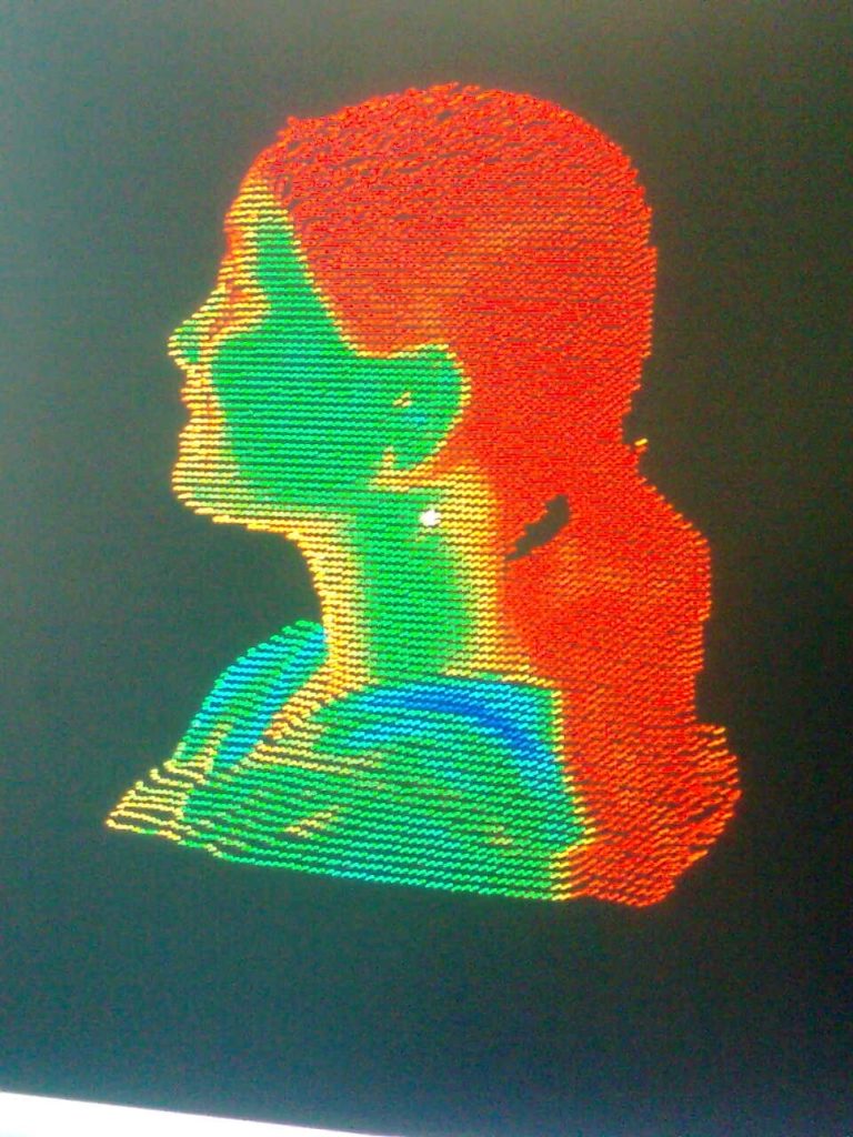

Laser Mapping – a very new concept just few years ago. Today it has found its usefulness from transportation to pipeline mapping to construction. The first time I ever encountered a laser camera was seven years ago, and I was so curious on how it worked, that I made a 3D model of my own head. Yeah, you read it right – MY HEAD!

There you go, the laser model (pun intented!). I was very surprised that the point cloud could actually catch my smile!
Very quickly I started to see the incredible potential of this application beyond mapping one’s own head! Several news pops up now and then about its myriad of uses. It really gets my attention when technology touches the lives of millions, especially in a developing country like India. Street Mapper has set out with a similar goal in mind – to laser map city centers and transportation networks across the entire country.

“India is making significant investment to improve its physical infrastructure,” commented Prof Dr. Bharat Lohani, Director and Mr Balaji Nagarajan CEO of Geokno Indian Private Limited , “which is why we are applying the very latest and best mobile mapping technology. One of our primary requirements, and fundamental to the selection of the StreetMapper system, was the requirement for engineering grade survey data. We also needed to be confident in the field performance and reliability of the system to minimise downtime.”
Geokno is a spin-off company from the Indian Institute of technology Kanpur specialising in GIS and related technologies such as LiDAR based surveying. Recognising the technical strengths of the company and the potential of the technology the GMR Group – one of the fastest growing infrastructure enterprises in the country, acquired a majority stake in Geokno.
Developed by UK based 3D Laser Mapping, in conjunction with German guidance and navigation specialists IGI, the StreetMapper system purchased by Geokno included two high speed, non-contact laser scanners specifically designed for mobile mapping as well as an export licence free fibre optic based Inertial Measurement Unit (IMU). The unique pod system also included a high resolution camera, specially designed lifting platform and a custom designed canopy. The newly supplied StreetMapper system can also be used for aerial projects with an airborne mount for the laser scanners and IMU.
Indians, Time to say cheese!


#


Next article

Light Detection and Ranging (LiDAR) belongs to one of those remote sensing technologies that have celebrated tremendous improvements within the last decade rendering it a practicable tool for public and private use. LiDAR measures varying distances between the sensor and the earth using light in form of a pulsated laser. The time difference between the emission of a laser pulse and the receipt of its reflected signal from the earth’s surface makes up the important height information of the terrain. The LiDAR sensor consists of a laser, a GPS receiver and a scanner for use over a wide area and is typically installed on an aircraft or helicopter. Particularly the improvement of the receivers, which today distinguish the backscattered signals at an accuracy of ns (nanoseconds), render the LiDAR technology highly usable for practical purposes due to an improved vertical resolution.
ADVANTAGES OF LIDAR
I already reported on the application of LiDAR in wind remote sensing related to the installation of wind parks. Another area, where LiDAR is gaining significant impact is the study of archaeological sites. LiDAR delivers a highly accurate digital elevation model of the scanned territory; the resolution is accurate down to the cm level vertically and to one meter horizontally. Another advantage is the penetrability of forest areas. From the 20.000 to 100.000 of laser points per second most will touch the leaves at different tree height levels, but at least a couple of laser pulses will always reach the ground scanning the relief of the earth’s surface unless the vegetated layer is extremely dense as for instance in tropical rainforests.
ARCHAEOLOGY
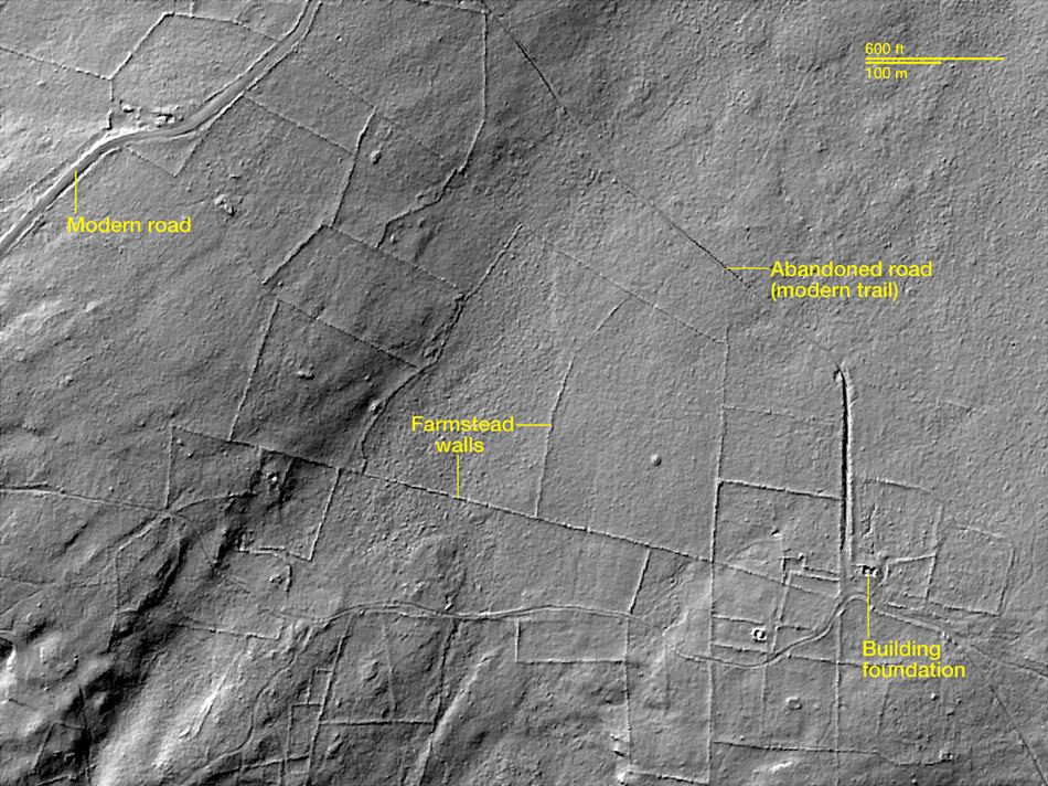
For an archaeological study site in New England scientists from the University of Connecticut under guidance of Katherine Johnson profited from that feature: The region is heavily forested today, which makes it difficult for archaeologists to get a better understanding of how the landscape looked like in colonial times. In the 18th century New England’s landscape was brightly covered by roads, farm walls and homesteads built by the first European settlers in North America. After 1950 the area was widely abandoned and re-conquered by forests making it impossible to see any structures those people left. The use of LiDAR finally enabled to penetrate the forest layer and reveal human structures as building foundations or stone walls creating an impression of how the terrain was organised, which could have never been accomplished without this technology. Suchlike, scientists uncovered subsistence farming in New England, something many people have no idea existed. The GPS coordinates of the LiDAR facilitates to walk in the woods and find any scanned structures desired.
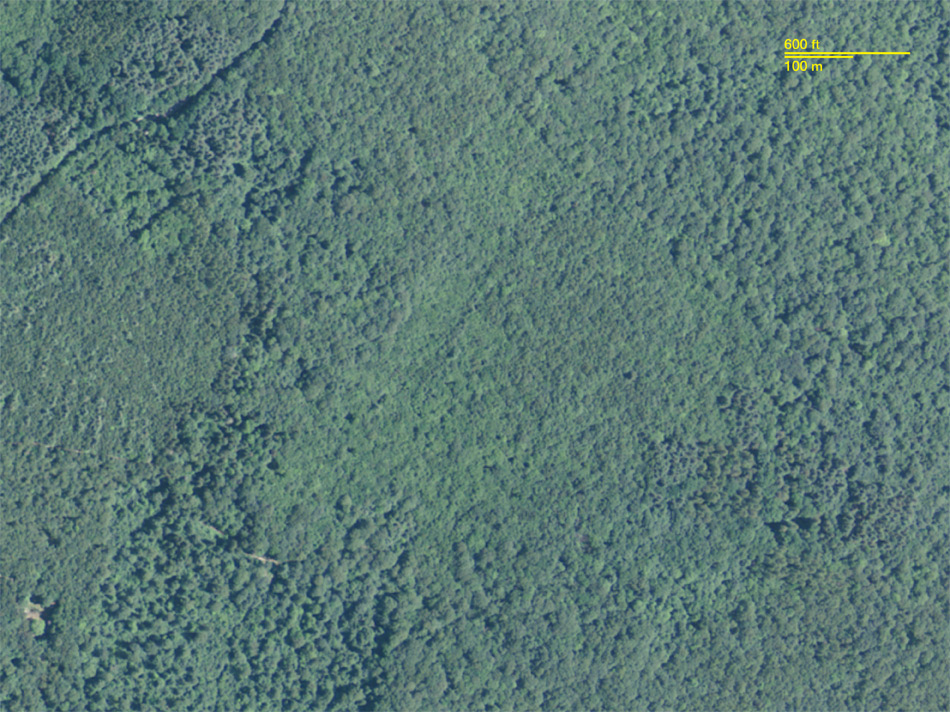
A study site in New England showing a true colour satelite image (above) and a LiDAR image from the same area (bottom). The LiDAR reveals the tracks of former civilisation that left building foundations, stone walls and roads behind and that can be observed in the relief. Source: National Geographic
Beyond the application in New England, LiDAR has been used to help researchers uncover ancient Maya buildings, roads, and other features of this civilization and even create a three-dimensional map of a Maya settlement in Belize. LiDAR has also been employed in order to get high-resolution models of Renaissance palaces, like the Salone dei Cinquecento in Florence Italy. In England, LiDAR is being used to discover new sites in the plains of Stonehenge.

Mayan city of Caracol, Belize, which is obscured by dense forest(right) that make traditional techniques difficult to apply. Source: BBC
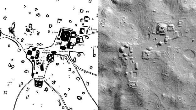
This 2D LiDAR image of Caracol shows terraces, topography and other archaeological remains. Source: BBC
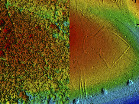
Lidar imagery demonstrating canopy penetration in open woodland in Savernake Forest. The image on the right hand shows the first return of a LiDAR from the tree crown and resembles an aerial image. The left image shows a filtered version, where only the ground signals were considered, which make up the terrain. The image reveals the presence of an Iron Age enclosure. Source: English Heritage
Overall, LiDAR is becoming a meaningful research tool in archaeology for understanding those civilisations that left permanent structures behind. For me, the use of LiDAR is a wonderful example of how ‘exotic’ the applications of remote sensing can become.
Source: GIS Lounge