How satellites assist wildfire management

How has the number of fires changed over the years, and why is it a growing problem?
Fires are increasingly posing a significant threat each year, impacting not only remote areas but also inhabited regions, endangering homes, possessions, and even lives. This escalating issue affects the entire world, and the United States serves as a prime example of the growing prevalence of large-scale fires, fueled by climate change. Since 2000, the US has experienced an annual average of 70,072 forest fires, burning approximately 7 million acres – more than twice the 3.3 million acres burned yearly in the 1990s, despite having more fires per year. Experts concur that ongoing greenhouse gas emissions intensify climate change, leading to increased surface temperatures and altered precipitation patterns, exacerbating the fire situation.
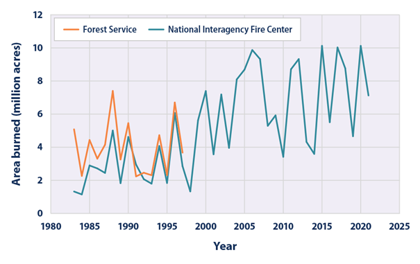
Annual wildfire-burned area from 1983 to 2021 in US, Source: https://www.epa.gov/climate-indicators/climate-change-indicators-wildfires
“Climate change is creating ideal conditions for larger, more intense fires,” said Robert Scheller, a professor of forestry and environmental resources in NC State’s College of Natural Resources, who uses geospatial analysis to study the effects of climate change and human activities on the long-term health of the landscape. “We’re already seeing fires that we didn’t expect to see until 2080.”
As of 2021, the average surface temperature of the United States was about 2.5 degrees Fahrenheit. Experts expect this figure to increase by 3 to 12 degrees Fahrenheit by 2100. This will result in more intense and frequent heat waves, while reducing rainfall in some areas. These conditions will make droughts worse, making landscapes across the country more flammable.
Fire monitoring is crucial for early detection, prediction, and firefighting, with satellite data providing invaluable assistance
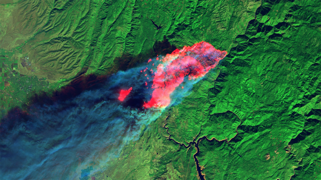
For both humans and the natural world, wildfires are a huge ecological disaster. They negatively affect the soil cover, the forest stand, the atmosphere, and the animal world. It only takes 50°C for valuable and protected plant species to perish, while during a wildfire the soil temperature reaches 700°C. Navigating through the forest can be very difficult, and finding the location of a fire is time-consuming. These are additional minutes and sometimes hours that allow the flames to spread. To ensure that these fires do not endanger people and animals, it is extremely important to observe the first moments after the fire is lit to identify its exact location, speed and direction of spread. Unfortunately, firefighters who are on the scene do not always have the ability to accurately calculate these factors. Also, scientists cannot accurately estimate the extent of the damage without high-quality statistical data showing the size of the fire and its location. This is why the success of forest fire risk mitigation largely depends on the amount of information available and the speed of decision-making. Monitoring is crucial for effective fire management and detecting fire outbreaks as soon as possible.
Without a doubt, satellite imagery is one of the best tools for monitoring wildfires, using innovative remote sensing technologies to provide cost-effective, timely solutions. Satellite images and weather data help to assess the current situation and the affected areas, and when combined with algorithms, satellite data can also help predict the course of fires. This will assist firefighters to control the spread of fires, and potentially reduce damage.
WildFireSat – a wildfire management solution with a Canadian example
Eighty-eight percent of Canada’s 4 million square kilometers of forested land are boreal forests, which have some of the largest and most intense wildfires in the world. Each year in Canada, some 7,500 fires consume more than 2.5 million hectares of forest, a territory nearly the size of Belgium.
The planned WildFireSat mission aims to monitor daily, from space, all active forest wildfires in Canada. In a country as vast as Canada, observation from space is the only way to obtain daily information on all active forest wildfires with the necessary precision. The main goal of WildFireSat is to support the management of wildfires, studying their behavior and the emissions of carbon, aerosols and other particles produced by fires.
The system’s satellites will be equipped with infrared sensors designed to measure the energy emitted by forest fires. This energy is referred to as Fire Radiative Power (FRP), which makes it possible to determine the characteristics of forest fires and their features, such as rate of spread and intensity. In addition, accurate data on carbon emissions from fires will be acquired, which is an important requirement of international agreements on carbon reporting. WildFireSat will also provide Canadians with precise data on air quality and smoke conditions. The mission will work with existing satellites to greatly expand our knowledge of forest fire behavior, and how that behavior is changing with our climate.
It’s also worth noting that losses due to fire can be reduced by improving the ability to make informed decisions, thereby defending communities and avoiding unnecessary evacuations. This will help to better protect both infrastructure and the environment, especially near populated areas. In addition, the measures will help to reduce health problems associated with smoke and air pollution.
The #WildFireSat mission will increase Canada’s ability to monitor #wildfires, providing faster, more accurate, information for air quality forecasting. https://t.co/TXCmWqdoNX
— Environment Canada (@environmentca) August 30, 2019
Emergency management services of the Copernicus CEMS program
Copernicus CEMS provides a free and open access global emergency mapping service. Users can get information about a disaster event at a scale, timeline and perspective that can only be obtained with geospatial information. This gives us the ability to analyze changes across the Earth over days, weeks, months or years. Products can be quickly shared with all agencies involved. This contributes to consistent and timely emergency response. CEMS deals not only with fires but all natural disasters (floods, fires, earthquakes, tsunamis, volcanic eruptions, landslides, storms, droughts, etc.), as well as man-made hazards (industrial accidents, oil spills, etc.). The area of observation extends beyond the European Union.
CEMS offers nine service components that cover every phase of the disaster and risk management cycle. Most of the CEMS components operate 24 hours a day, seven days a week, year-round, and those relevant to firefighting include:
– Rapid Mapping – provides print-ready maps and digital geospatial data sets within hours of a disaster to quickly visualize the scope and impact of an event.
– Risk and Recovery Mapping – supports preparedness, prevention and recovery of affected areas.
– European Forest Fire Information System (EFFIS) – monitors forest fire activity in near real-time. EFFIS supports the management of forest fires at national and regional levels in EU member states and in the Middle East and North Africa.
A number of applications are available through EFFIS, such as the Current Situation Viewer, Current Statistics Portal, and Wildfire Risk Viewer, among others. All applications are available here.
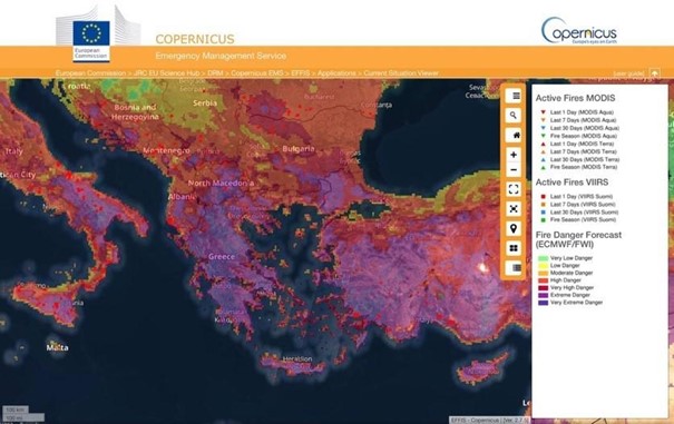
EFFIS Current Situation Viewer
NASA’s Fire Information for Resource Management System (FIRMS)
NASA’s FIRMS and Worldview tools provide active fire data within three hours of observation from Earth-observing satellites to users around the world. Active fire and hotspot data can be viewed in FIRMS Fire Map or NASA’s Worldview, delivered as email alerts or downloaded in the following formats: SHP, KML, TXT or WMS. Since summer of 2022, data for active fires on the continental United States are also available in real time (within one hour of satellite observation) and in ultra-real time – within one minute – using direct transmission data and new software developed by the Space Science and Engineering Center (SSEC) of the University of Wisconsin-Madison.
“The more recent the data, the higher its value in assessing the location, extent and intensity of newly detected fire activity,” said Brad Quayle, manager of the Disturbance Assessment and Services (DAS) program at the USDA Forest Service. In addition, Everett Hinkley, manager of the National Remote Sensing Program at the U.S. Forest Service’s Office of Geospatial Management, added, “FIRMS gives us ‘at-a-glance’ knowledge of where wildfires are and where the active wildfire area is … In some remote areas, it is our only window into what is happening with wildfires and allows us to track their development.”
FIRMS has active fire data acquired from the Visible Infrared Imaging Radiometer Suite (VIIRS) instruments onboard the Suomi National Polar-orbiting Partnership (Suomi NPP) satellite and the Moderate Resolution Imaging Spectroradiometer (MODIS) instruments onboard NASA’s Aqua and Terra satellites.
It is also worth mentioning that FIRMS is part of NASA’s Land, Atmosphere Near real-time Capability for EOS (LANCE). Diane Davies, operations manager for LANCE, notes that in addition to information on active fires, “LANCE provides a wide range of data and near real-time imagery from NASA and other scientific satellite missions to help users monitor hazards and disasters, including wildfires, smoke, air quality, dust storms and floods.”
Conclusions
Satellites use innovative technologies that have a lot of potential when it comes to wildfires. Remote sensing from wildfire satellites can help forest managers identify burned areas, classify burn levels and estimate the total area burned, as well as acquire accurate data on carbon emissions and environmental pollution. With remote sensing, we can obtain measurements of many different wildfires and determine their size, location, duration and temperature, data that would be unavailable without the use of satellites. In addition, current wildfire detection satellites can identify wildfires before they are observed on the ground, which is often 10-15 minutes before an emergency call arrives. Therefore, monitoring forest wildfires using earth observation data is critical.
Did you like the article? Read more and subscribe to our monthly newsletter!

#Categories

Next article
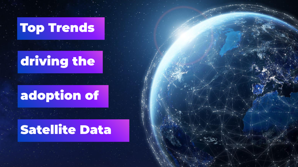
Top trends driving the adoption of Earth observation data through 2023 and beyond
Satellite-based Earth observation data is no longer a niche technology, but rather a ubiquitous presence in today’s world. In 2022, it made headlines due to its crucial role in the global political landscape.
However, despite its widespread use by governments, the adoption of satellite data for wider applications has been slow—with notable exceptions in the agriculture industry, and in vegetation management for power and utility organizations. 2023 is poised to be the year when this trend takes a sharp turn, as more and more industries embrace the power of satellite data.
What’s causing this shift in the way Earth Observation data is used? There are several key factors, relating to changing business models within the industry, regulatory requirements, and advances in technology.
Regulation and reporting requirements
Many companies are now facing stricter laws when it comes to issues like sustainable supply chains and ESG reporting, with satellite data and analytics proving to be critical tools for monitoring and documenting compliance.
In 2021, new legislation was proposed by the European Commission to address global deforestation, and this is finally starting to have an impact this year. These regulations impose mandatory due diligence requirements on operators who market commodities associated with deforestation, such as soy, beef, palm oil, wood, cocoa, and coffee. Companies must gather geographic information on the land where their products were produced, with the aim of guaranteeing that only deforestation-free goods reach the EU market.
This development is likely to create a huge demand for satellite data for supply chain tracking, and there will likely be a proliferation of companies joining startups like SourceMap or Satelligence in this space.
In the realm of Environmental, Social and Governance (ESG) reporting, regulations are also driving the increased use of satellite data. Public companies are now required to publish their climate risk and ESG analysis together with their quarterly and annual financial reports. This space is still evolving, with organizations like the Task Force on Climate-related Financial Disclosures (TCFD) working to establish standards and metrics for non-financial reporting, but corporations are slowly waking up to the idea that Earth Observation and geospatial data can be key tools in the process.
Democratizing Earth observation data
The EO industry itself is also waking up to its shortcomings. Chief amongst these are a lack of standardization and a restrictive pricing structure. Dealing with these issues will remove barriers of technical feasibility and cost from multiple new use cases.
Data standardization
Diverse data standards are a significant bottleneck in the sector: Each vendor may claim to offer Analysis Ready Data (ARD), but significant technical challenges begin to arise when trying to combine data from different sources. Startups often spend a huge amount of time resolving issues with integration, rather than finding solutions for their clients.
The concept of ARD for geospatial imagery is not new. Guidelines for a minimum level of data processing and organization were developed and published by the Committee on Earth Observation Satellite (CEOS) back in 2019, but an official standard has never been established. However, this is about to change: From November to December 2022, the Open Geospatial Consortium (OGC) collected public comments on a proposed ARD Standards Working Group Charter, and will now bring it to life. The adoption of this standard from 2023 should dramatically improve the ease with which satellite data from different vendors can be combined, removing integration issues for existing companies and making EO data more accessible to a wider range of users.
New industry business models
Historically, legacy satellite providers have made enormous profits from government and military contracts, and have therefore been reluctant to change their pricing structure to prevent conflict with these key clients. However, these inflexible business models have long been seen as a hindrance to the widespread adoption of satellite data by the commercial sector.
Currently, the industry operates with a pricing structure of around $20-30 per km2 for 30cm data, with a minimum order of 50km2, which is simply not cost-effective for many applications—particularly any use case that requires frequent or cyclical operations.
The good news is this situation is changing, with legacy providers becoming more open to new business models—for example, blending their data into analytical products rather than just providing GeoTIFF image files via FTP. An increasing number of products and models such as this are likely to be introduced in 2023.
Technological tools increasing adoption of Earth observation data
It’s not just the ability to access and process satellite data which is important in geospatial analytics, it’s the ability to do it at scale.
Cloud-native architecture and integrations
In recent years, cloud-native architectures have become increasingly sophisticated and widespread, with Cloud-Optimized GeoTIFFs (COGs) and Spatiotemporal Asset Catalogs (STACs) becoming the tools of choice for organizing, storing, and sharing remote sensing data. This has made it much easier for organizations to use this data effectively on a large scale.
So too has the increasing integration of the EO ecosystem with geographic information systems (GIS) tools. One of the most successful examples of this trend is the recent integration between Esri and Up42, which allows users to easily request imagery from Airbus, Capella Space, Head Aerospace and other leading providers directly from ArcGIS Pro.
Advancements in Artificial Intelligence (AI)
Advancements in Artificial Intelligence (AI) and Machine Learning (ML) are also driving the growing adoption of EO data. We can expect to see a continued increase in the use of these technologies, which enable real-time analysis of enormous data sets with greater efficiency and accuracy than ever before. AI tools can empower organizations of all sizes to utilize satellite data, which should lead to a proliferation of new, innovative solutions in the EO space.
New constellations Increasing affordability of higher resolution data?
Unfortunately, 2023 is unlikely to see a significant drop in the price of very high resolution (30cm or more) data, as the supply is still so low. There was an expectation that this would change with the launch of two new Pleiades Neo satellites in December, but they didn’t make it into orbit. However, the industry is still poised for growth, with the Maxar Legion 30cm constellation and Planet’s Pelican satellites both expected to launch in 2023.
The resulting increase in supply is expected to drive down prices and provide more flexibility for customers—albeit from 2024, rather than this year. The availability of data with a resolution of 30cm every 30-45 minutes for any location in the world will open up exciting new possibilities for the commercial sector; and the shift towards affordability will enable a wide variety of new use cases requiring high-resolution data at regular intervals.
A pivotal year for the industry driving growth for the next decade
2023 promises to be a landmark year for the satellite data industry, with a number of trends set to drive growth and adoption. The increasing flexibility of legacy satellite providers, coupled with a greater demand for accountability and transparency, will lead to the emergence of both new markets and new applications for EO data. Additionally, advances in technology and the increasing proliferation of higher-resolution satellite constellations will enable organizations to unlock new insights, driving innovation in the sector.
These developments all point to a bright future for the satellite data industry, setting the stage for growth in the coming years. In 2023, we can expect to see positive trends propelling the industry forward, and laying the foundation for a decade of progress.
Did you like the article? Read more and subscribe to our monthly newsletter!