How Satellite Data Can Help to Mitigate the Impact of Mining

Editor’s note: This article was written as part of EO Hub – a journalistic collaboration between UP42 and Geoawesomeness. Created for policymakers, decision makers, geospatial experts and enthusiasts alike, EO Hub is a key resource for anyone trying to understand how Earth observation is transforming our world. Read more about EO Hub here.
It’s no secret that mining isn’t great for the environment. But the many challenges faced by the mining sector today often boil down to one particular difficulty: data collection and analysis that allows for meaningful change.
Commercial mines can be vast—sometimes spread across several dozen kilometres. Added to this, they are often located in remote, hard-to-reach parts of the world, which limits access for emergency response teams. For these reasons, ensuring miner safety in the event of a disaster can be extremely difficult..
In addition, surveying and restoring former mines is also a major challenge. However, satellite data might be about to change that.
Data obtained by satellites can have a significant positive impact on the mining sector. Beyond enhancing safety and restoration efforts, it can be used throughout the entire mining cycle: from identification of mine location, through design and construction of the pit and structures, right up to and including mine rehabilitation.
Little wonder, then, that earth observation technology is growing in popularity in the sector—and that it is becoming increasingly relevant in terms of Environmental, Social and Governance (ESG) principles. The two areas that are potentially the most significant and highlight the hugely positive impact that earth observation data can have on the sector are environmentalism and safety.
Satellite and drone data
Traditionally, mining companies have collected data using conventional in-person land surveying techniques. However, considering the size of the sites involved, gathering data for entire areas on mining sites and their surroundings with any kind of regularity is difficult.
In recent years, the modern mining industry has turned to remote sensors and drones as a solution. UAV technology tends to be applied on a ‘local’ level, where it is used in measuring volume—for example, the size of stockpiles—or for surveying slopes and rock faces after blasting. Drones are well-suited for this kind of job and complement traditional ‘total station’ measurement.
However, the major issue regarding drone data is that it is simply not practical to use UAVs for mapping and situational awareness over the enormous 30–50km2 areas that comprise some of today’s mining sites. As such, drones are rarely used for collecting and processing data focused on safety and the environment, which takes place some distance away from the main exploration/extraction areas, often with the added complication of dense vegetation and protected areas.
In cases such as these, high-resolution satellite imagery—for example, the 30cm resolution Pleaides Neo data—can be used in addition to the data provided by drones, sensors, and conventional means. Significantly, platforms such as UP42 have now given mining companies (and other relevant organizations) the ability to ‘task’ satellites to capture on-demand data—satellite imagery which can be captured up to several times a day (if required), providing situational awareness for areas of virtually any size, giving total control over the data. This enables the collection of regular, high-resolution data for constant monitoring. Moreover, satellite data can be used to generate 3D digital elevation models , or harnessed to evaluate vegetation health using multispectral analysis.
Environmental benefits from satellite data
Sadly, the mining industry has had myriad negative effects on the environment throughout its history. Impacts from mining activities include: soil erosion, formation of sinkholes, loss of biodiversity, and contamination of water and soil, including chemical leaks, leading to consequential harm to human populations and wildlife in surrounding areas. Satellite data can help to mitigate this damage in three key areas.
First, earth observation data can be used to monitor the impact of mining activity on the environment over time. Secondly, the data can help to detect potential environmental risks for example related to water contamination or deforestation near-real-time. Finally, satellite imagery can help companies adhere to environmental rehabilitation policies and laws (generally, companies must commit to eventual restoration of the area of activities to its original state). The images can help companies achieve this, and also prove that it has been done.
An environmental example: Freeport-McMoRan mining company
Background
Mining company Freeport-McMoRan operates internationally, extracting copper, gold and molybdenum. Freeport has committed to several sustainability goals, including environmental protection, with the slogan ‘Accelerating the Future, Responsibly’.
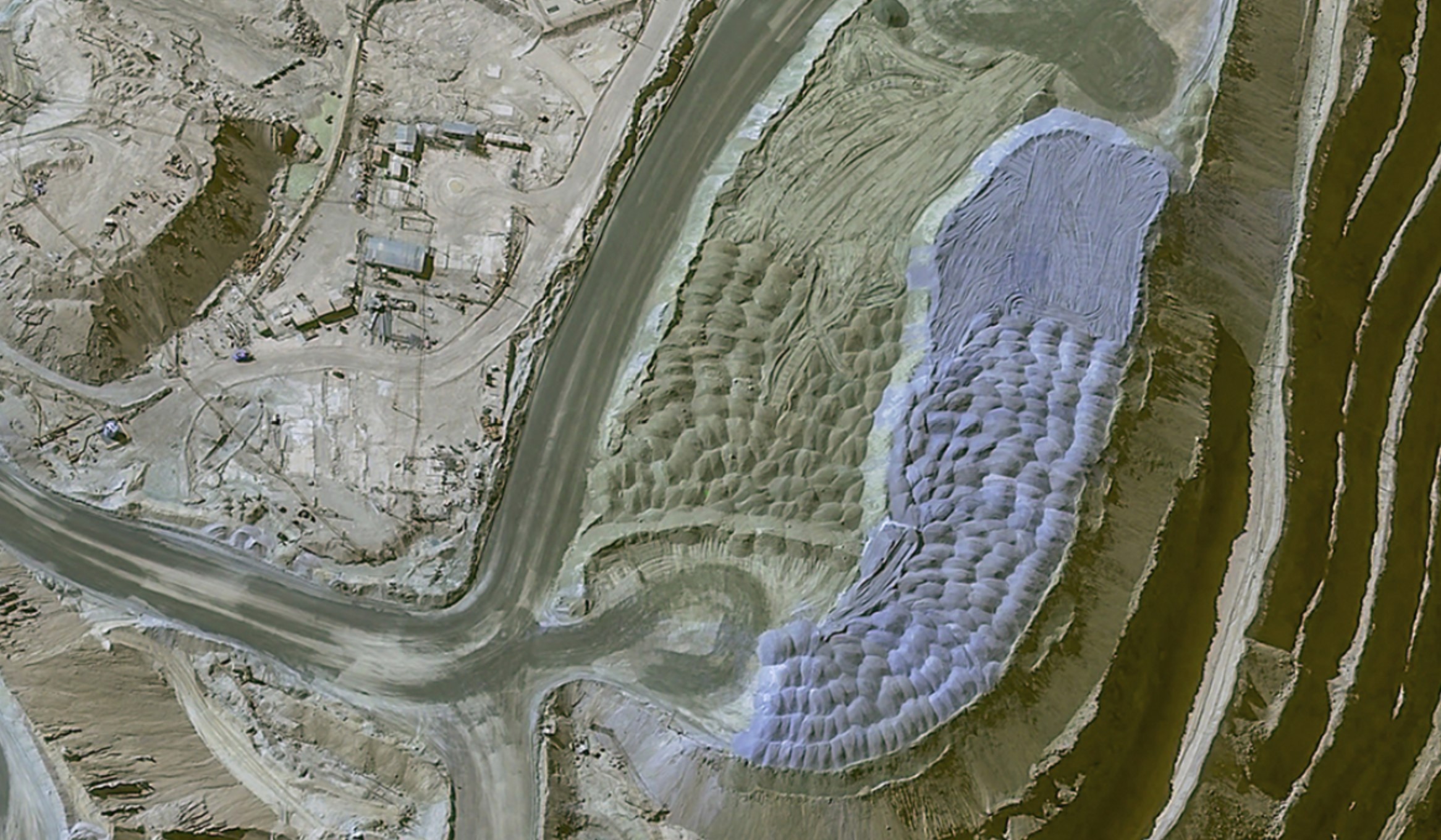
One of Freeport’s goals relates to its ‘tailings’ facilities (tailings are the waste products produced from mining) with a stated target of zero ‘unplanned discharges’ or ‘catastrophic failures’ from these sites. Using conventional land surveying methods, Freeport staff would need to journey along the dam crest by foot—a long and potentially dangerous journey of several miles—to take water measurements.
Use of satellite data
Freeport harnesses a combination of remote sensing and earth observation data, including Sentinel-2, Landsat, Planet, and drones, with imagery collected on a near-daily basis. Using this data, the company’s engineers are able to monitor their tailings ponds, measuring them in relation to the outer embankments. Multi-spectral imagery and analysis also enables the measurement of beach width and permits highly accurate water volume measurement.
With the assistance of satellites, Freeport’s engineers are able to gain an improved understanding of the tailings sites while also remaining safe—and also increasing efficiency, as they are able to better plan their workflows.
Do you like the article? Subscribe to our newsletter
Safety benefits from satellite data
According to The World Counts, “More people are killed or injured in the mining industry than in any other industry.” Officially, the number stands at 15,000 annually, but this is considered a very conservative estimate, with the true total likely to be hundreds of thousands of deaths a year.
Whatever the number, there’s no doubt that a mine site can be a dangerous place. It involves explosive activities, heavy equipment, and contact with chemicals—not to mention climate factors. To avoid mistakes and accidents that can cause injury or death, close monitoring of activities and constant safety assessments are critical.
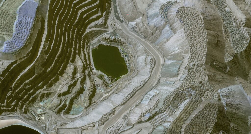
Safety example: Wai Khar open cast jade mine, Myanmar
Background
Myanmar produces up to 90% of the world’s jade, but conditions at the country’s jade mines are often poor and dangerous. In 2020, catastrophe struck at the Wai Khar open cast mine, when more than 170 people were killed in a landslide. The initial theory was that the tragedy was caused by monsoon rainfall.
Following the disaster, a study was conducted by analyzing satellite and other remotely-sensed data, which revealed that poor pit design and mismanagement had played a major part in the landslide. Specifically, the mine walls were constructed at a precariously steep angle, especially considering the nature of the surrounding rock. Images collected in the preceding 7 years proved that there had been a series of landslides in the same location, with data also showing ‘accelerated deformation.’
Potential for satellite data
Many mining sites globally are remote and rural, and therefore regular field studies are often impractical and expensive. As a result, changes (such as land displacement, landslides and deformation) frequently go unnoticed, which can lead to increased risk of danger to personnel and assets.
The disaster at Wai Khar starkly highlighted the need for accurate and regular safety monitoring of mining sites. The subsequent study demonstrated that the use of earth observation data (both optical and SAR) would be ideal in achieving this, as satellites are able to provide high-resolution images of vast areas, with frequent re-visits.
The future of mining: mitigating environmental impact and improving safety
Historically, the impact of mines on the environment has been devastating. However, with access to high-resolution, time-sensitive data, companies are finding ways to measure and reduce this impact—such as Freeport with their tailings ponds—and to restore habitats to their former state upon the conclusion of operations.
At the same, safety issues have plagued the sector, with an alarmingly high rate of fatal accidents. Mining disasters, like the devastating one at the Wai Khar jade mine, can still happen even with sufficient safety practices; however, by implementing Earth observation data, the risks can be massively reduced.
By helping to solve age-old problems with innovative new solutions, Earth observation is critical in enabling the mining industry to plan for the future, meet ESG targets, and play a part in a better tomorrow.

#Data source

Next article
How Satellite Data is Bringing Value to Commodity Trading
Editor’s note: This article was written as part of EO Hub – a journalistic collaboration between UP42 and Geoawesomeness. Created for policymakers, decision makers, geospatial experts and enthusiasts alike, EO Hub is a key resource for anyone trying to understand how Earth observation is transforming our world. Read more about EO Hub here.
Commodity trading relates to the buying and selling of raw materials like oil, coal, metals, or agricultural products, amongst others. Success basically comes down to how accurately a speculator can predict supply and demand. To do this, investors need accurate and reliable information—and they need to have it before anyone else does.
This is where satellites come in. While the bulk of commodity trading involves investing in “futures contracts,” the commodities themselves are all physical assets and therefore have one thing in common: they have a physical footprint, which means they can be observed from the sky.
The use of Earth observation data is becoming increasingly important in commodities trading, providing investors with reliable and accurate information to inform their decision-making before markets are impacted. Although investors won’t base their decisions solely on satellite data, it can be an important tool in verifying market data with physical evidence, helping to detect anomalies or trends which can help identify significant investment opportunities and mitigate risks. The use of EO data is not replacing any existing process. It is another value-adding layer of information to forecasting models, which eventually help traders make better decisions.
Accessing and analyzing satellite data is easier than ever before
The number of satellites now in orbit—and, just as importantly, the quality of the data offered by public and private satellite programs—is getting to a level where we can observe any place on Earth multiple times a day. It can be done using optical satellites such as Pléiades Neo, which offers very high resolution imagery, or using SAR satellites, which can penetrate cloud coverage and provide data even at night.
In the past, the biggest challenge for those dealing with satellite data has been its price. However, with growing market competition, and online platforms such as UP42, the price of satellite data is becoming more transparent, and buying it—historically a challenge—is becoming more convenient. It’s now also easy for companies to task satellites to capture data for any Area of Interest. The data can then be used by organizations to assist in predictive models and forecasts, supporting a wide range of trading and investment activities.
This all means that asset management companies, stockbrokers, and commodity traders are able to access time-sensitive business intelligence long before markets are affected. By monitoring weather anomalies, supply chains, inventory levels, and production activity, data sets based on Earth Observation are making it easier for stakeholders to forecast supply and demand, and to evaluate risk.
Use cases for Earth observation in commodities trading
From a technical perspective, extracting business intelligence insights from Earth observation data is no more complicated than any other geospatial analysis. The same techniques are used, just in a different context. Basic algorithms include object counting, vegetation indexes, change detection, and volumetric measurements. These can be combined with more advanced image analytics algorithms and Deep Learning models.
Object counting
A principal use case of Earth observation is object detection and counting. This has multiple applications, but one of the best examples for business is car counting, which can indicate the traffic at retail locations, for instance. This saves analysts significant amounts of time in conducting pattern-of-life analyses or collecting other activity-based intelligence.
Specifically, companies like Orbital Insight select areas of interest and regularly monitor them over time. Orbital Insight observes and analyzes consumer traffic at a quarter of a million retail locations, including 3,300 high-demand US shopping centers. The company’s car detection algorithm uses wide area object detection from Pléiades imagery to accurately identify and quantify cars. For example, in 2015, there were two outbreaks of E. Coli at Chipotle food outlets. Following this, Orbital observed a sharp decline in car traffic at the chain’s restaurants, which was an invaluable predictor before a 40% decline in the stock price.
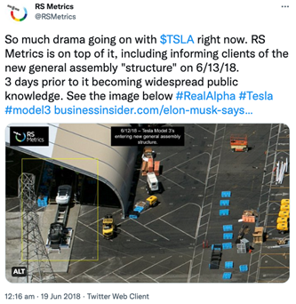
Another example of car counting relates to the production of vehicles. In June of 2018, RS Metrics informed clients of the latest developments at Tesla. Three days before it was public knowledge, they revealed details of changes to Tesla’s manufacturing activity, including a new assembly line structure, and increased output production rates. Canny investors were able to act accordingly.
Vegetation indexes
Well known by the Earth observation industry, but probably less so by commodity traders, vegetation indexes can help to analyze key parameters related to crops.
Normally used for precision agriculture, vegetation indexes offer traders unique insights into crop acreage and likely yields, which lead directly to prices of agriculture products. The algorithms used for this sort of analysis include NDVI (which stands for normalized difference vegetation index) and Moisture Stress Index, among others.
Such analysis can be done based on open source data such as Sentinel or nearly any other satellite data. One of the notable examples is mentioned by Planet. Its spectral analysis algorithms can differentiate between different crop types such as soy and corn, aiding the prediction of annual yield estimations (and, consequently, price projections). Planet makes multiple captures of this data throughout the growing season, before the US Department of Agriculture (USDA) publishes their annual crop acreage report at the end of June, meaning traders can get ahead of the game.
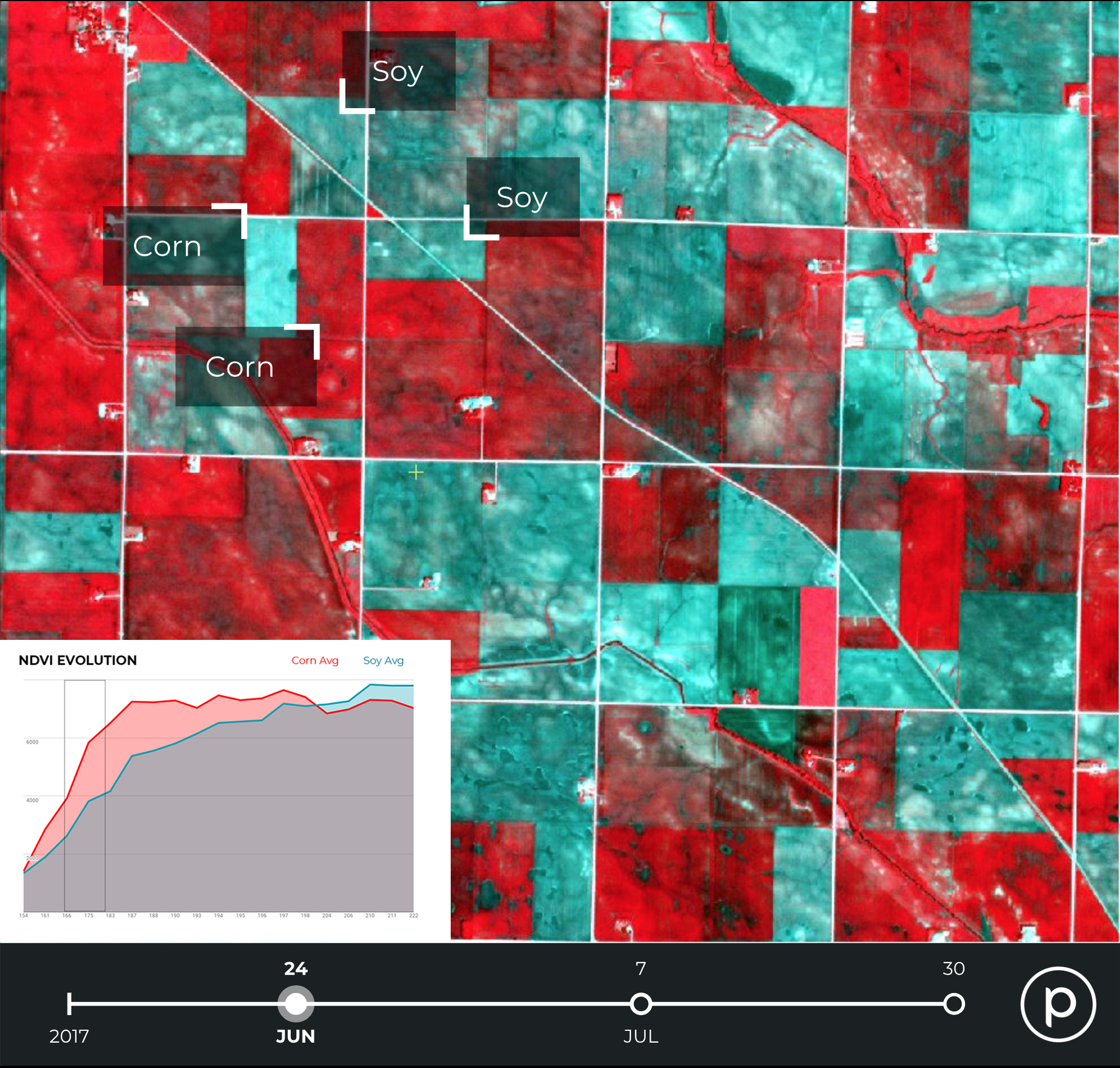
Planet: Soy and corn crops identified by NDVI
Change detection
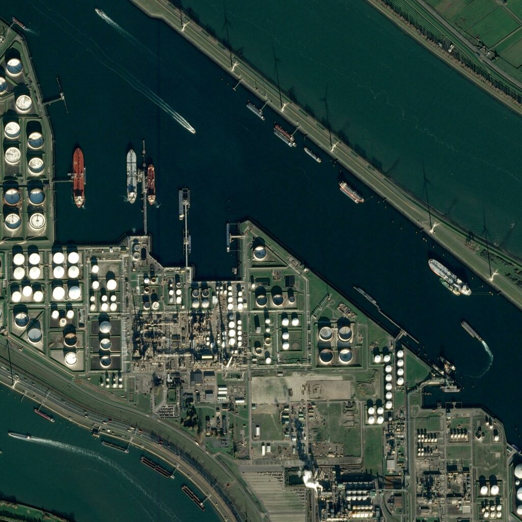
Change detection refers to the use case in which companies select areas of interest and periodically analyze the imagery to detect changes or anomalies, on newly available, archived, or tasked imagery. This is of particular interest when it comes to the hugely significant oil and gas industry (although there are, of course, many other applications).
Airbus, among other players, offers a Storage Tank Detection model which can monitor areas of interest to detect new oil and gas infrastructure and then compare it with the past data. At the height of the pandemic, information from satellite data proved to calm investors’ fears that storage facilities were reaching capacity, pre-empting a recovery in oil prices.
Interestingly, satellite data is used to estimate the amount of crude oil in storage tanks, by measuring shadows. Oil is often stored in tanks which have ‘floating’ roofs, which rise or fall depending on how much oil is inside. By capturing the crescent-shaped shadows cast by the sun, the algorithms can detect and measure the height of the roof and therefore the quantity of oil within. This technology is of particular use when it comes to emerging markets, like China, where data is less available.
Change detection is also relevant for analyzing supply chains, especially at sea, providing data on factors including port traffic and occupancy. A powerful example of this could be seen during the Ever Given Suez Canal blockage, where satellite imagery was able to show the number of cargo ships queuing in the canal, and the progression of the operation to release the trapped vessel.
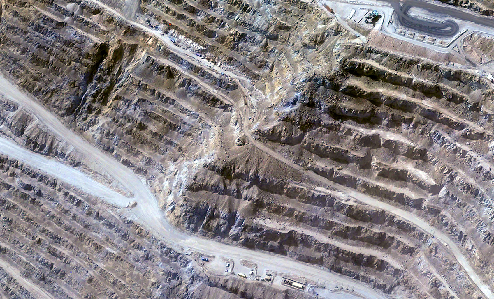
Digital elevation models and volumetric measurements
Most satellite analytics is done in 2D, but another use case finding popularity relates to 3D data. This enables measurement of volume, and can be derived from stereo-enabled satellite imagery, which are used to produce digital elevantion models such as WorldDEM dataset from Airbus with 12m resolution and the forthcoming WorldDEM Neo with a higher 5m resolution.
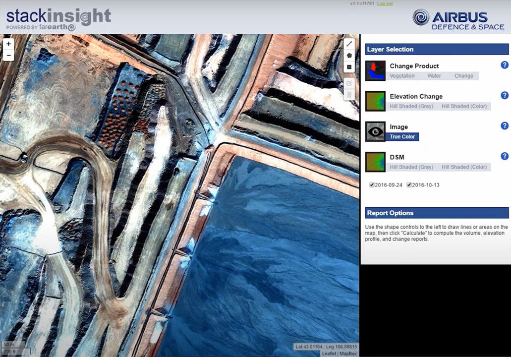
Airbus: still from ‘stack insight’ explanatory video
Most commonly used in the mining industry, such data can be applied to estimate the extraction of raw materials at open-pit mines, by measuring the size of stacks at the site. One example of this is at Kumba Iron Ore’s massive 100km2 open pit mine in South Africa, where Airbus and technology firm Pinkmatter have collaborated to provide Kumba with weekly updates featuring accurate information on extraction volumes and other changes on site.
Beyond mining, digital elevation modeling has the potential to be used for any type of material that can be stacked or piled, including building materials or raw products like timber. Data such as this could be used in conjunction with other, previously mentioned algorithms (such as object detection for the number of vehicles visiting a site), to further inform investors on production activity, for example.
Invaluable information for the future of commodity trading
Earth observation can provide critical information to traders, investors, and other stakeholders in commodity trading. Traditional models often rely on historical or theoretical data, but by providing real-time data on production, inventories, and supply chains, satellite imagery and analytics can greatly increase the reliability and accuracy of future price predictions.
From a technical perspective, it’s incredibly straightforward to use satellite data for remote sensing and analysis. However, it can be difficult to do that at scale—and in these cases, solutions such as off-the-shelf data and algorithms (from platforms such as UP42, for example) could be used to make it easier.
Of course, there is an added challenge when integrating satellite data with existing forecasting models (which can be unreliable), and stakeholders are still discovering how best to use the data. But, with the growing number of satellites providing imagery and the maturity of algorithms to perform analysis, it seems inevitable that satellite data will be playing an increasingly major role in the sector, reshaping how traders invest in stocks, commodities, and real assets.
Environmental benefits from satellite data
Sadly, the mining industry has had myriad negative effects on the environment throughout its history. Impacts from mining activities include: soil erosion, formation of sinkholes, loss of biodiversity, and contamination of water and soil, including chemical leaks, leading to consequential harm to human populations and wildlife in surrounding areas. Satellite data can help to mitigate this damage in three key areas.
First, earth observation data can be used to monitor the impact of mining activity on the environment over time. Secondly, the data can help to detect potential environmental risks for example related to water contamination or deforestation near-real-time. Finally, satellite imagery can help companies adhere to environmental rehabilitation policies and laws (generally, companies must commit to eventual restoration of the area of activities to its original state). The images can help companies achieve this, and also prove that it has been done.
An environmental example: Freeport-McMoRan mining company
Background
Mining company Freeport-McMoRan operates internationally, extracting copper, gold and molybdenum. Freeport has committed to several sustainability goals, including environmental protection, with the slogan ‘Accelerating the Future, Responsibly’.
One of Freeport’s goals relates to its ‘tailings’ facilities (tailings are the waste products produced from mining) with a stated target of zero ‘unplanned discharges’ or ‘catastrophic failures’ from these sites. Using conventional land surveying methods, Freeport staff would need to journey along the dam crest by foot—a long and potentially dangerous journey of several miles—to take water measurements.
Use of satellite data
Freeport harnesses a combination of remote sensing and earth observation data, including Sentinel-2, Landsat, Planet, and drones, with imagery collected on a near-daily basis. Using this data, the company’s engineers are able to monitor their tailings ponds, measuring them in relation to the outer embankments. Multi-spectral imagery and analysis also enables the measurement of beach width and permits highly accurate water volume measurement.
With the assistance of satellites, Freeport’s engineers are able to gain an improved understanding of the tailings sites while also remaining safe—and also increasing efficiency, as they are able to better plan their workflows.
Do you like the article? Subscribe to our newsletter
Safety benefits from satellite data
According to The World Counts, “More people are killed or injured in the mining industry than in any other industry.” Officially, the number stands at 15,000 annually, but this is considered a very conservative estimate, with the true total likely to be hundreds of thousands of deaths a year.
Whatever the number, there’s no doubt that a mine site can be a dangerous place. It involves explosive activities, heavy equipment, and contact with chemicals—not to mention climate factors. To avoid mistakes and accidents that can cause injury or death, close monitoring of activities and constant safety assessments are critical.
Safety example: Wai Khar open cast jade mine, Myanmar
Background
Myanmar produces up to 90% of the world’s jade, but conditions at the country’s jade mines are often poor and dangerous. In 2020, catastrophe struck at the Wai Khar open cast mine, when more than 170 people were killed in a landslide. The initial theory was that the tragedy was caused by monsoon rainfall.
Following the disaster, a study was conducted by analyzing satellite and other remotely-sensed data, which revealed that poor pit design and mismanagement had played a major part in the landslide. Specifically, the mine walls were constructed at a precariously steep angle, especially considering the nature of the surrounding rock. Images collected in the preceding 7 years proved that there had been a series of landslides in the same location, with data also showing ‘accelerated deformation.’
Potential for satellite data
Many mining sites globally are remote and rural, and therefore regular field studies are often impractical and expensive. As a result, changes (such as land displacement, landslides and deformation) frequently go unnoticed, which can lead to increased risk of danger to personnel and assets.
The disaster at Wai Khar starkly highlighted the need for accurate and regular safety monitoring of mining sites. The subsequent study demonstrated that the use of earth observation data (both optical and SAR) would be ideal in achieving this, as satellites are able to provide high-resolution images of vast areas, with frequent re-visits.
The future of mining: mitigating environmental impact and improving safety
Historically, the impact of mines on the environment has been devastating. However, with access to high-resolution, time-sensitive data, companies are finding ways to measure and reduce this impact—such as Freeport with their tailings ponds—and to restore habitats to their former state upon the conclusion of operations.
At the same, safety issues have plagued the sector, with an alarmingly high rate of fatal accidents. Mining disasters, like the devastating one at the Wai Khar jade mine, can still happen even with sufficient safety practices; however, by implementing Earth observation data, the risks can be massively reduced.
By helping to solve age-old problems with innovative new solutions, Earth observation is critical in enabling the mining industry to plan for the future, meet ESG targets, and play a part in a better tomorrow.