
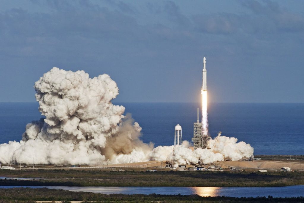
And the countdown runs: in less than a day the first German optical earth observation satellite will enter the orbit over Cape Canaveral in Florida.
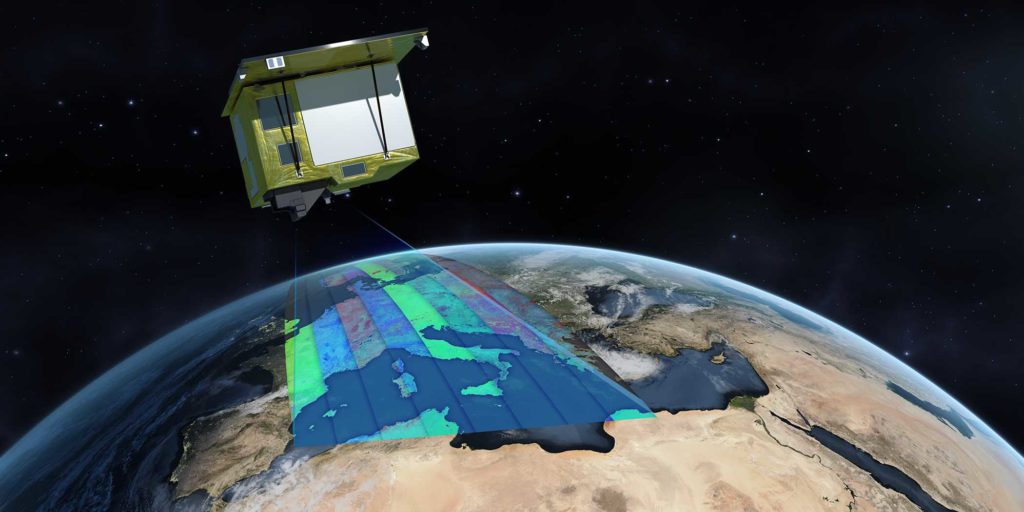
With its TerraSAR-X and TanDEM-X satellites Germany has become a reliable provider of SAR data since 2007. Now it is time for extension, the Environmental Mapping and Analysis Program (=EnMAP) will be the first German hyperspectral satellite mission dedicated to the monitoring of the Earth’s environment on a global scale.
The keyword “hyperspectral” points to a wide spectral recording range from 420nm to 1000nm (VNIR) and 900nm to 2450nm (SWIR) combined with a short spectral sampling distance of 6.5nm (VNIR) and 10nm (SWIR) respectively. This functional characteristic is very useful to measure key dynamic processes of terrestrial ecosystems relating to agriculture, forestry, soil and geology, and aquatic environments, thereof mainly coastal zones and inland waters. EnMAP was primarily planned as a scientific mission by the German Research Center for Geosciences (GFZ) with the main objective to study environmental processes and the impact of human activity. However, it has potential to also become operationally used.
EnMAP as a mission will be managed by the Space Agency of the German Aerospace Center (DLR). The satellite was developed and built by the German based company OHB, headquatered in Bremen. Responsibility regarding the establishment and operation of the ground segment will be assumed by the Earth Observation Center and the German Space Operations Center, both at DLR and experienced in handling EO-derived data and commanding satellite missions.
Did you like the article? Read more and subscribe to our monthly newsletter!
LAUNCH and LIVE STREAM
Everything I am writing is still in future, but this will change very soon. Tomorrow, on 1st April 2022 at 18:24 CEST the EnMAP satellite will be launched by a Falcon 9 rocket from SpaceX from Cape Caneveral in Florida. The German Phoenix TV program will broadcast the launch in cooperation with ARD from the DRL Space Agency in Bonn between 17:25 and 19:55 CEST. Please feel invited to follow the event on LIVE-STREAM
Some hard key facts about EnMAP:
- Revisit time: 4 days (+/-30° off-nadir tilt) and 27 days (+/-5° off-nadir tilt)
- Geometric resultion: 30m x 30m (swath 30km), 5000 km per day with 512 Gbit
on-board mass memory - Repeat cycle: 27 days and 398 orbits (polar, sun-synchroneous)
- Spectral range: 420 – 2450nm
- Spectral sampling distance: 6.5nm (VNIR) and 10nm (SWIR)
- Radiometric resolution: 14bits
- Operational lifetime: > 5 years

#Data type


Next article
How green is Satellite Monitoring? Let’s do the Math!

As more and more satellites are launched to Space, there are concerns about rocket launches’ greenhouse gas (GHG) emissions. In this article, we attempt to break down the rocket’s emission into more feasible chunks per satellite. We take a look at the concrete use case of vegetation monitoring and compare the satellites’ CO2 emissions to the more traditional approach of using helicopters. Spoiler alert: satellites win. By how much? Continue reading to find out!
The Space Industry is developing at great speed over the last few years. As key figures, 4,877 active satellites were orbiting the Earth in 2021, and this number will probably fourfold over the next ten years, as 17,000 satellites are expected to be launched to Space by 2031.
In parallel, we hear some concerns about rocket launches and greenhouse gas (GHG) emissions causing climate change and respiratory problems by trapping heat. Bringing the different pieces together, one can worry about the environmental impact of launching satellites to Space: are satellites environmentally friendly, despite the rockets’ CO2 footprint?
When it comes to Utility Vegetation Management, LiveEO’s core product, is satellite analysis a greener alternative than helicopter inspection? Reading this article, you may be (positively) surprised by the result of our documented research!
To arrive in the atmosphere, satellites are launched by rockets. If you’ve already seen images or videos of a rocket launch, you might have been impressed, but also concerned, by the heavy white smoke left behind. But what does it contain exactly? Its composition depends on the rocket and its propellant.
In case of the Falcon 9, which we will be looking at, it consists primarily of CO2, water vapor, soot, and nitrogen oxygens. In our comparison and calculation, we will focus on CO2 emissions. Both rockets and helicopters also emit other substances (and noise). Our comparison is without doubt simplified, but well suited to illustrate the magnitude of difference we are dealing with.
Satellite vs Helicopter: Comparison of CO2 emissions
Let’s turn to a concrete example that we deal with at LiveEO: Vegetation Monitoring. An alternative to satellite inspection of vegetation along power lines is helicopter inspection. We look at the use case of vegetation monitoring of the German Railway network, which is the largest in Europe. How do satellite monitoring hold up against helicopters in terms of GHG emissions? Let’s look at the data.
The Eurocopter AS350-B3 is commonly used for inspection flights. This helicopter uses jet fuel. According to the Swiss Federal Office of Civil Aviation FOCA, the AS350-B3 burns roughly 160 kg of jet fuel per hour. Jet Fuel causes CO2 at a defined ratio of 3.16 kilograms of CO2 per 1 kilogram of fuel consumed. This means in one flight hour, the helicopter emits 500 kg CO2.
Let’s assume the helicopter flies at a speed of 100 km/h. They probably fly faster, but we need to account for take-off and landing and in the real world, the helicopters would also have to return to their starting point.
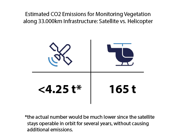
To cover the German railway network of 33000 km would equal to 330 flight hours (13.75 days non-stop), which would then, in turn, mean 165000 kg or 165 metric tons of CO2 emitted to fly over the entire network once with a helicopter.
Planet Labs recently sent 44 of their SuperDove satellites into orbit aboard a rideshare mission with a SpaceX Falcon 9 rocket, along with more than 50 other small satellites.
The Falcon 9 releases 425 tonnes of CO2 per launch. Broken down, this would mean you could attribute 4.25 tons of CO2 emissions to each SuperDove on that rocket.
One SuperDove satellite is capable of capturing imagery of 320,000 km² in one single day (16 orbits á 20,000km²). The size of the entire country of Germany is 357,022 km². Obviously, there are more satellites involved in capturing the data as part of the constellation, just like not one single helicopter would fly over the entire network. But it would take little more than the capacity of a single satellite to capture data of the entire country.
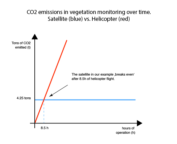
So in the face-to-face comparison, we end up at 4,25 tons of CO2 for the satellite as part of the rocket launch versus 165 tons of CO2 for the helicopter. Important to note: The satellite’s emissions remain constant over its lifetime (one-off), while the helicopter emits with every minute its engine is running. This is an even more decisive outcome we expected before going into research.
Satellite Emissions are One-Off
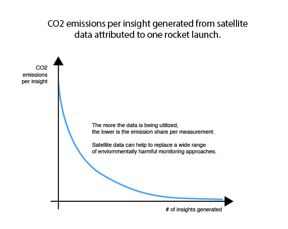
But, it does not even end here. Satellites like the one in our example stay operative in orbit for 3-5 years and constantly collect different types of data on weather, climate, and satellite monitoring applications. For example, they can give us insights on wildfires, volcanoes, sea surface and atmospheric temperatures, precipitation, etc. During their entire lifetime, satellites collect data en passant that can make other, environmentally harmful ways of acquiring that data, obsolete.
To really understand the environmental impact of satellite monitoring, we would need to break down the emissions per measurement made by the satellite and used in the real world, and then compare it to the emissions that would have been caused by the monitoring solution they replace. How green the satellite data eventually depends on how extensively the captured data is utilized. The more insights/measurements are generated from every data point recorded, the lower will be the GHG emission share per insight. Additionally, we would need to factor in the direct benefits satellite insights have on the environment, e.g. through better-informed management of forests and other ecosystems.
Obviously, the calculation we made is heavily simplified and can only serve as an illustration for one use case where satellites can substitute environmentally harmful practices and beat them with flying colours. We did not take into account emissions by production, other GHG than CO2, emissions caused by data processing to name just a few things omitted. Interestingly, it was quite difficult to find numbers on helicopter emissions, which indicates that there is at the very least a transparency issue.
Data to make our Planet more Sustainable
We are well aware that rockets emit CO2 and water vapor that trap outgoing thermal radiation and contribute to global warming. That is why we do not advocate for all rocket launches, like Space tourism, but for rocket launches having a meaningful purpose and bringing valuable insights to companies and people to make our planet more sustainable.
Satellite monitoring can provide us with more comprehensive knowledge of the ecosystems we live in and help us to directly mitigate risks caused by climate change. The better we learn to utilize the data satellites record, the greener it becomes.
Sources:
How many satellites are orbiting the Earth in 2021? – Geospatial World
Are space launches bad for the environment? – BBC Science Focus Magazine
How much do rockets pollute? – Everyday Astronaut
SpaceX Launches Rocket With 143 Satellites – The Most Ever Flown On A Single Mission – Forbes
‘Fourfold increase’ in satellites over the next 10 years to 17,000 – Capacity Media
Helicopters for aerial mapping via laser mapping tech such as LiDAR – Corporate Helicopters
Guidance on the Determination of Helicopter Emissions – Bazl
Fact Sheet | The Growth in Greenhouse Gas Emissions from Commercial Aviation (2019) | White Papers | EESI
Ask Smithsonian: How Does a Satellite Stay Up?.
SpaceX: World record number of satellites launched – BBC News
SpaceX launches third dedicated smallsat rideshare mission – SpaceNews
What is the environmental impact rockets have on our air? – Everyday Astronaut
Pradon, C. V. M. (2021). Estimating launch vehicle trajectories and atmospheric emissions (Doctoral dissertation, Massachusetts Institute of Technology).
Did you like the article? Read more and subscribe to our monthly newsletter!
LAUNCH and LIVE STREAM
Everything I am writing is still in future, but this will change very soon. Tomorrow, on 1st April 2022 at 18:24 CEST the EnMAP satellite will be launched by a Falcon 9 rocket from SpaceX from Cape Caneveral in Florida. The German Phoenix TV program will broadcast the launch in cooperation with ARD from the DRL Space Agency in Bonn between 17:25 and 19:55 CEST. Please feel invited to follow the event on LIVE-STREAM
Some hard key facts about EnMAP:
- Revisit time: 4 days (+/-30° off-nadir tilt) and 27 days (+/-5° off-nadir tilt)
- Geometric resultion: 30m x 30m (swath 30km), 5000 km per day with 512 Gbit
on-board mass memory - Repeat cycle: 27 days and 398 orbits (polar, sun-synchroneous)
- Spectral range: 420 – 2450nm
- Spectral sampling distance: 6.5nm (VNIR) and 10nm (SWIR)
- Radiometric resolution: 14bits
- Operational lifetime: > 5 years