Detecting Bilge Dumping pollution at Sea with Satellite Data

Editor’s note: This article was written as part of EO Hub – a journalistic collaboration between UP42 and Geoawesomeness. Created for policymakers, decision makers, geospatial experts and enthusiasts alike, EO Hub is a key resource for anyone trying to understand how Earth observation is transforming our world. Read more about EO Hub here.
Of the most common crimes that are committed on the open seas (piracy, illegal fishing, oil spills, etc.), there is one that almost no one talks about – bilge dumping. It’s grown steadily in scale and seems to have been hiding in the shadows for many years now. However, that’s all about to change.
“Most people don’t realize that every day in multiple places in the ocean around the world, large commercial ships are getting away with dumping untreated oily bilge waste directly into the sea. But with the technology we have now, we’re changing that.”
This is a quote from John Amos, the founder of SkyTruth – a non-profit organization based in West Virginia. They are tackling the problem of bilge dumping head-on using satellite imagery and machine learning to identify and bring accountability to ships that engage in this practice. It’s a fascinating use of technology and one that can do a lot of good for our oceans.
What Is Bilge Dumping and Why Does It Matter?
To understand bilge dumping we must first look at what bilge water is. A bilge is the lowest part of a ship where dirty water collects. But it’s not exactly water. It’s a nasty concoction of any liquids that leak from the engines and the massive pipe infrastructure in the bottom of these ships. This can include oil, cleaning products, chemicals, and a variety of other things and they all collect in the bilge water itself.
As explained in a video from Deutsche Welle: “Bilge water is so toxic that it has been regulated for more than 50 years. It’s hellish drainage you really don’t want to dump into the ocean.” Yet that’s exactly what so many vessels do – they dump the bilge into the ocean regardless.
Marine regulations stipulate that ships are supposed to collect the bilge water and dispose of it safely at the next harbor, but unfortunately, that’s not what happens in a lot of cases. The sheer scale of this practice is a significant concern because the environmental impact is stark and long-lasting. The oil can suffocate and intoxicate fish and birds, forever harming the marine ecosystems that we should be working to protect. And it’s not only the current generation of animals, but there has also been research to show that bilge water can harm the fertility cycle which then impacts the animals that are yet to be born.
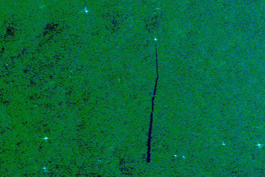
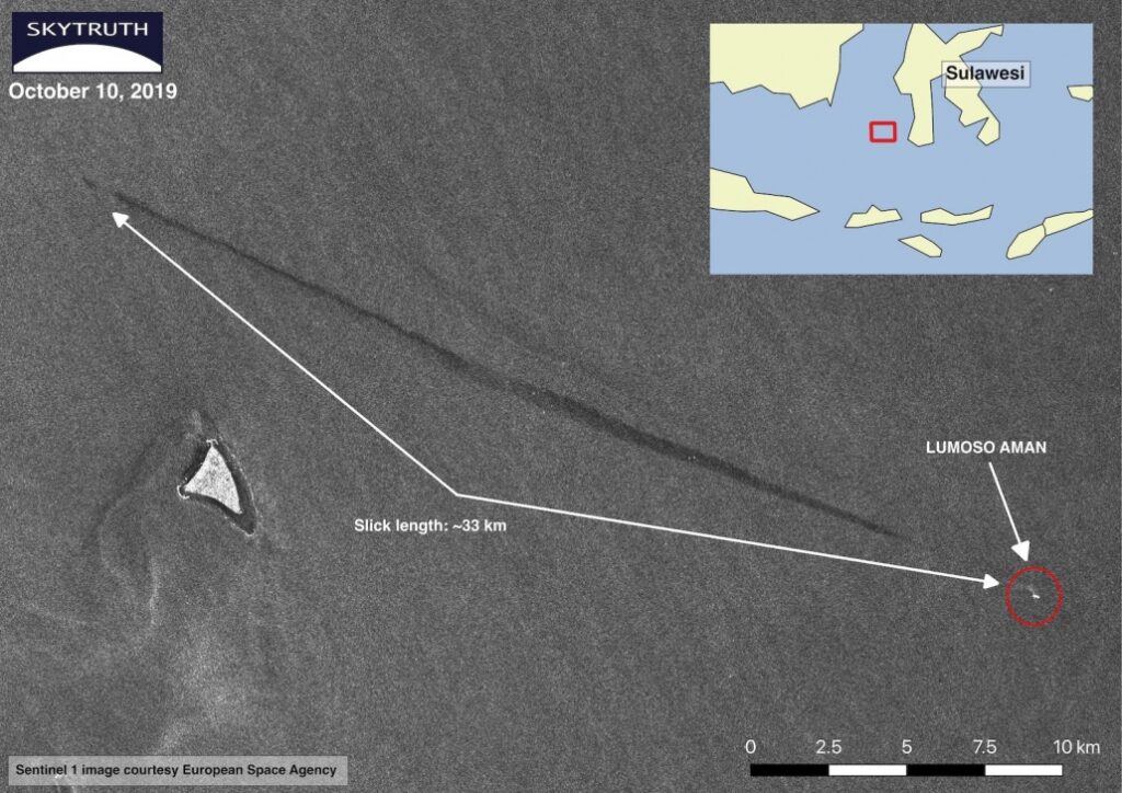
SkyTruth’s research shows that there are hundreds of these bilge dumping events happening every year, and the compounding effects can be disastrous for the long-term health of our oceans. These slicks average around 56km in length and are quite consistent across many of the major shipping lines around the world. This is certainly not an isolated problem and we’re already seeing the downstream environmental effects. The most obvious ones are the mysterious oil that has been showing up on beaches in Brazil, Singapore, Nigeria, and several other countries. But those are just the ones that are staring us in the face – which are likely to be only a small proportion of the damage being inflicted on ocean life. Serious action needs to be taken to shine a light on the problem and bring it into mainstream consciousness so that we can tackle it as a society and bring the perpetrators to justice.
What is the Solution?
Typically, these sorts of crimes are very difficult to get a handle on because it’s near-impossible to monitor the open ocean ecosystem with any level of efficiency or precision. But all that has changed with significant advances in satellite imagery.
SkyTruth found a fascinating new method that would help them pick up the bilge dumping as it was happening and then match it to the specific vessel that was responsible. They started by analyzing Sentinel-1 radar data to detect the pollution and to measure the thickness of an oil slick and the exact coordinates of where it was. They did this by training a machine learning model to comb through thousands of images and look for instances of an oil slick.
Initially, there were plenty of false positives – things that looked like an oil slick, but were actually just a naturally occurring event – but with time, the algorithm has been improved significantly and is pretty accurate in finding the oil slicks that are not naturally occurring and therefore that are likely to have been caused by bilge dumping. The improvements in accuracy can also be credited to significant improvements in satellite imagery availability and resolution, which gives the machine learning models more pixels to work with.
They now had the slicks in their sights, but that alone was not enough. They had no way of proving which ship did the dumping. That was until Amos and his team discovered a crucial dataset that changed everything – AIS. He explains it best in a recent video:
“We’re using satellite images to detect these oily slicks in the ocean left by vessels, but we’re also using another satellite collected data called AIS – automatic identification system. And these are radio frequency broadcasts that many ships at sea send out frequently to identify who they are, where they’re going, and how fast they are moving. By correlating those signals that we collect from one set of satellites with the oil slicks that we see using another set of satellites – very often we can identify the vessel that is the polluter responsible for that oil slick.”
The AIS data is a regulatory requirement for ships so that collisions are avoided, but this use case allows us to tie exact coordinates and timing to ships – which are then compared to the slicks themselves. The ability to tie together these two disparate data sets is really what turned the entire process into one that had legs and could deliver the insights needed for law enforcement to start to get involved.
This process is at the core of SkyTruth’s Project Cerulean which has already made some important strides towards providing the sort of transparency and accountability that we need to put an end to bilge dumping. It’s an elegant solution that leverages the potential of satellite data and machine learning to shine light on the problem – thus giving us the data that we need to then pursue legal action against the companies who are doing the bilge dumping.
Conclusions
When you recognize what satellite imagery and machine learning can do in tandem for problems like this, it opens up a whole new realm of possibility for the practice of geospatial analysis. We can leverage tools and ideas like this to tackle some of the biggest problems our world faces in an efficient and highly precise way – just like SkyTruth is doing.
None of this would be possible, though without significant advances in data collection and utilization. All the satellite imagery and the AIS data can be sourced from a platform like UP42 which provides a wide array of data products in a scalable and affordable way. Their AIS offering in particular makes this work possible and is going a long way in helping geospatial professionals to do their best work. Users can order, task, and process their data through a single touchpoint, making the entire process that much more effective at scale.
This, combined with the right methodology, gives us a highly valuable set of information that helps law enforcement get to work. The industry needs to get behind efforts like this and push regulators and governments to take action to stop bilge dumping. If we can do that, then we might just find ourselves at an inflection point where we can stop this dangerous and irresponsible practice for good.
Did you like the article? Subscribe to our monthly newsletter:

#Data source


Next article
Unpacking the Airbus One Tasking Offering and Why It Matters
Ever since the dawn of high-quality satellite imagery, one of the most significant bottlenecks that have hampered the growth of the industry has been the time it takes to get your images. Due to its complex nature, the process could take a few days to several weeks, making it unsuited for a number of industrial use cases.
Very recently, we’ve seen some promising progress in this regard, and that timeframe has been drastically shortened. Airbus, one of the Earth Observation pioneers, is the first to play the game. With the launch of Pléiades Neo, its new 30cm resolution satellite constellation, the French aerospace company reimagined the tasking process. It enabled a workflow where the satellite imagery can be tasked, acquired, processed and accessed (streamed or downloaded) in near real-time, 24/7, via an easy-to-use platform, OneAtlas.
Let’s look at the Airbus One Tasking offering to understand how this works and unpack why it’s such an important step forward for the industry.
What Is One Tasking and What Does it Involve?
For the past several years, Airbus clients have used OneAtlas as their digital platform for tasking and managing their interactions with all of Airbus’ Earth Observation products. This user interface has greatly simplified the image procurement process and has made it easier than ever to access both archived data and request new ones.
One Tasking is the next step in the platform iteration. It allows the customer to have direct access to the relevant tasking features, meaning that by simply specifying their data parameters, they can get highly accurate and precise image data in full autonomy. This removes all of the friction involved and allows a user to treat their satellite imagery acquisitions as a 24/7 self-service portal right throughout the process.
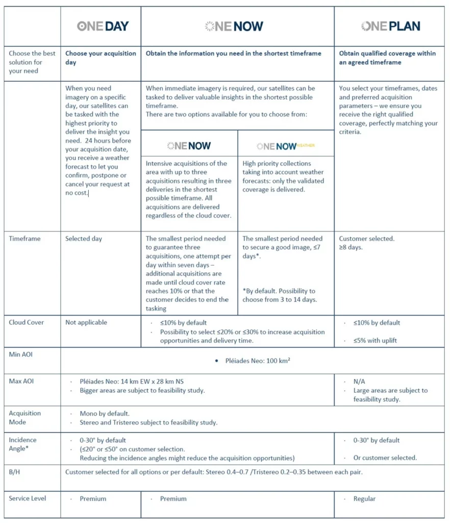
There are going to be three different levels of service that sit under the One Tasking umbrella for Pléiades Neo:
- One Day: This offering allows the user to specify the exact day that they’d like images on ahead of time or just a few hours before acquisition. This is ideal for urgent imagery projects where data must be collected and delivered on a specific day. Airbus will give it a top priority. 24 hours before the acquisition, users get a weather forecast to confirm, postpone, or cancel the request.
- One Now. The second offering has been specially created when immediate imagery is required. Airbus will apply the highest satellite tasking priority to the urgent request and will take into account the weather – before capturing the requested images over the shortest period of time. The images are delivered immediately after acquisition. Users can thus access valuable insights in the shortest possible timeframe.
- One Plan. The final option is when a user selects a time frame over which the imagery acquisition can take place. This can be in the order of weeks or months, and it allows Airbus to wait for perfect weather, good angles, and everything else that is needed to capture a highly precise and accurate image. Customers (or users) will receive the right qualified coverage, perfectly matching their project milestones.
Each of these three options is suitable for different use cases, and users will benefit from having much more control and flexibility when it comes to procuring their images. Having all of this accessible through an easy-to-use portal (OneAtlas) is also a game changer for pushing the boundaries of what is possible with this technology.
Why Does Speed Matter for Tasking?
The key innovation here is simply cutting through the administrative burden and making the entire tasking process more efficient. Instead of having your projects built around the constraints of your satellite imagery, you can tackle things the other way around – knowing that you can access the images you need as and when you need them. This agility and certainty can then unlock a range of ancillary benefits that help to maximize the value of the data that is captured.
To get a sense of just how fast this could get, we spoke to Pauline Sol-Wagner, Product Marketing Manager for Pléiades Neo from Airbus. She gave this example of one of the fastest scenarios:
“Let’s imagine that a request is sent to the system at 09h44. The image will be downloaded over the Airbus reception station and can be available by 10h57. So in just one hour and 13 minutes, the request can be sent to the satellite, processed, and the image can be directly available on your computer.”
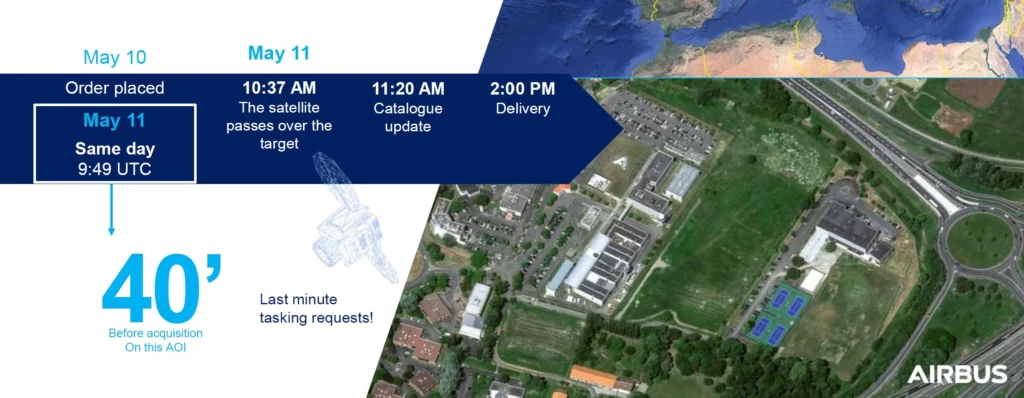
That’s staggering. And while the speed will depend on a variety of factors, especially the location of the area of interest, this shows just how powerful One Tasking can be. With this sort of efficiency, users can expand how they use the images in ways that we probably haven’t even thought of yet – because they can rely on much more consistent results right on cue.
Applications and Use Cases
The existing use cases for high-resolution Pléiades Neo data in emergency response, disaster response, asset monitoring, defence, and others will continue to be important applications here – that is for sure. The improved turnaround time will compound the value for these users and deliver even more bang for their buck. But it will also open up new avenues of exploration – for example, in the world of damage assessment.
You could imagine a private client monitoring deforestation, pipeline damage, long-term agricultural impacts, and the like because they can be very precise with their image timing – allowing for a more consistent study and better research results overall. In addition, by combining this with drone data and other forms of information, an entirely new realm of opportunity is there for the taking.
All of this is possible at somewhere between 25 and 90 euros per km2– a price point that is not just affordable but incredible value for money when you consider what you’re getting for it. One Tasking from Airbus is a clear statement of intent from a company that is dedicated to creating the best satellite products out there. All that remains now is for users to start engaging with the self-service portal so we can see just how much of an impact it’s really going to have for geospatial professionals.
You can read more about how to get started here or via the official Airbus website.