

Is Digital Mapping cutting edge, with lots of innovation? Or is it mature, and very slow to change?
It depends on who you ask.
For those interested in self-driving cars, digital mapping is dynamic and cool. AI. Machine Learning. Drones. Those cool custom Google cars. VCs going gaga.
For those interested in discovering places through local advertising, digital mapping is a big yawn. CTR. PPC. Yellow Pages II. Tiny pins on top of lots of streets for as long as you can remember.
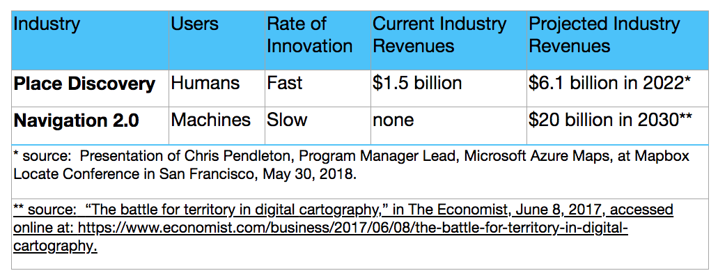
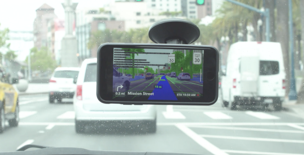
The difference is so stark that one might even consider digital mapping to be two parallel industries: Navigation 2.0 versus Place Discovery. (Navigation 1.0 was for human drivers, and version 2.0 is for self-driving cars.) See the screenshot below for a quick comparison of these two industries.
I chose Place Discovery – the seemingly boring industry – for my startup company, Streetography. Actually, when I researched these two industries closely, I found that Place Discovery can be very interesting, and it certainly has a very large market. It’s what people do with maps when they’re asking questions like, “What’s it like to be in this place?”, or, “What will I find when I get to this place?” For instance, when you look at a map when booking an Airbnb, or when contemplating what you’ll do during a weekend trip to Manhattan, you’re using it for Place Discovery.
Currently, practically all of Google Maps’ revenues are come from Place Discovery, via local advertising and API sales to apps and websites that offer Place Discovery to their users, mostly in travel & real estate.
The only thing that makes Place Discovery boring is that all the big mapping companies have largely ignored it for many years. Navigation 2.0 is very interesting and exciting, especially to the leader in Digital Mapping, Google.
During the intellectual property trial between Google’s sister company, Waymo, and Uber, Google disclosed that it had invested $1.4 billion in Waymo’s self-driving car technology between 2009 and 2015, and that figure has probably reached roughly $2 billion today. A good chunk of that investment has gone into detailed maps for Navigation 2.0. Separately, Google Maps has invested heavily in Navigation 2.0 maps in recent years.
Given the world-changing potential of self-driving cars, most industry observers think this is a prudent investment for Google. In fact, many other companies, from computer companies like Apple to car companies like General Motors, are also pouring hundreds of millions of dollars into self-driving cars.
Meanwhile, Place Discovery continues to do very well, albeit at a lesser growth rate projection than Navigation 2.0. A 2016 Morgan Stanley estimate cited in this article says that Google Maps would earn $1.5 billion in revenue from local advertising in 2017, and that number would grow to $5 billion in 2020. Microsoft estimates that this market will grow to $6.1 billion in 2022.
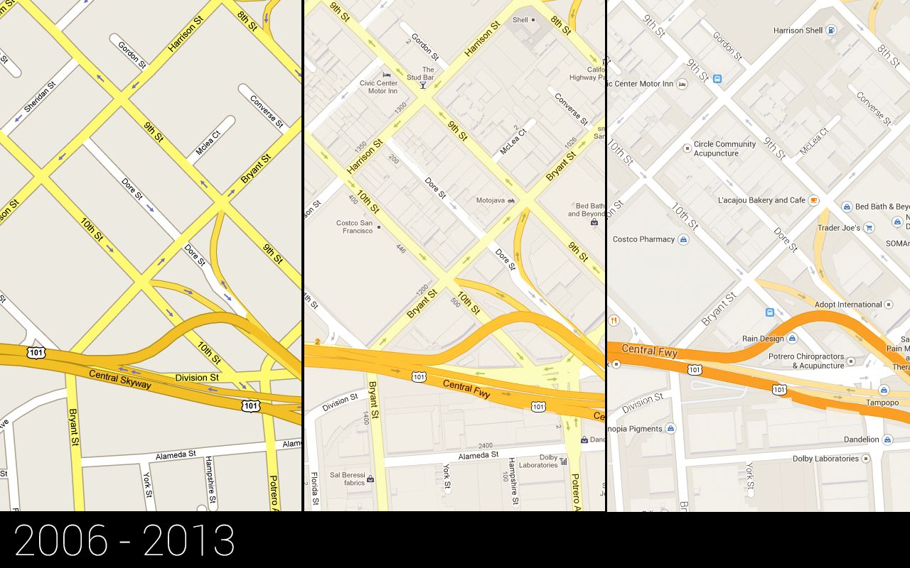 However, as noted above, Place Discovery has not received much attention from the mapping industry over the past few years. The best way to see this is to see how online mapping user interfaces have evolved since Place Discovery’s aim is to attract human clicks/taps on maps. See the screen image above. That’s from a TechCrunch article on the evolution of the Google Maps user interface. That’s right – it went practically nowhere from 2006 to 2013.
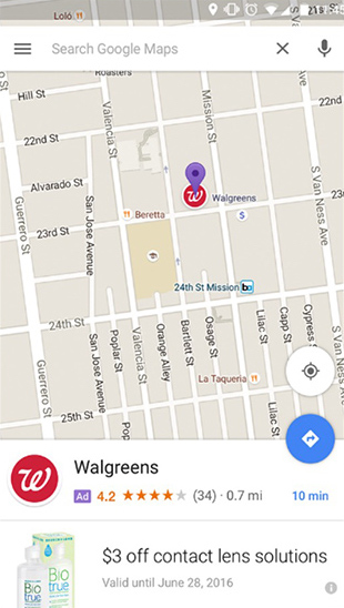
Then, in 2017, Google Maps introduced “promoted pins.” See the screenshot below. They added a tiny logo pin to mark the location of a business. Meanwhile, apps like Facebook, Instagram, and Snapchat are literally exploding with large photos and videos.
 My company, Streetography, is totally focused on Place Discovery for digital maps. Our Photo Map platform places photos right on maps, with each photo cut out by the borders of geographic entities – blocks, neighbourhoods, cities, counties, states/regions, or countries. We believe this focus makes our Photo Map platform much better than other mapping platforms for Place Discovery.
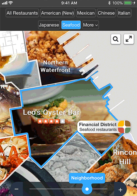
If you’re interested in this, you can see it live at Find San Francisco Restaurants. If you were in San Francisco’s Financial District and were in the mood for a seafood dinner, this screen would be a lot more engaging than a Google Map with lots of roads and tiny pins. Those stars are Yelp ratings, and if you tap on a restaurant’s photo, you get more info, like price range, the description, and reviews. The user can access a list of all seafood restaurants by tapping on the button entitled, “Financial District Seafood restaurants”.
You could imagine that, sometime in the near future, that centre overlay bordered in blue might show videos of seafood restaurants. Maybe one of the videos shows a live view of the restaurant, with waiters serving tables and live music.
By freeing Streetography’s Photo Maps from the requirement of helping users with navigation, they do a far better job of showing users places. Roads and the white space between them might be important to a map that’s focused on navigation, but for Place Discovery, they’re not nearly as important as photos and videos of places.
Would an advertiser, such as a restaurant or a theme park, rather have a tiny pin on a map or a far larger photo or video? Which is more likely to engage users, and, ultimately, to entice a click?
Humans will benefit greatly from self-driving cars and the Navigation 2.0 maps those cars use to find their way. While riding in those cars, they’ll have a lot of idle time to plan what they’ll do at their destinations. So, I predict that the emergence of self-driving cars will substantially increase the demand for place discovery in mapping. I hope that mapping companies like Streetography will be ready to capitalize on this opportunity.


#Business


Next article

Last week, 1,400 geospatial developers and technologists converged in San Francisco for a two-day user conference organized by location data platform Mapbox. While it wouldn’t be possible for us to get you the deets from all the 60 sessions, covering everything from AR localization to LiDAR, here’s a quick lowdown on the major products and partnerships announced at the event.
Mapbox Vision SDK
Vision SDK: This SDK can transform any mobile camera into a powerful sensor and allows developers to build heads-up displays for augmented reality-powered navigation directly into an iOS or Android app.
Native AR: If you want to showcase your points of interest using a location-based AR experience, Mapbox has not one but two SDKs for you – React Native AR SDK that talks to the code at a native level for cross-platform apps, and SceneKit SDK that works with Apple’s native toolkit to let iOS developers build lightweight AR experiences.
Uber geospatial toolbox support: With its GL Custom Layers API that is slated to launch this summer, Mapbox will bring the powerful visualization capabilities of Uber’s just-released open source geospatial toolkit to its developer community.
Must read: Uber’s amazing geospatial data viz tool joins the open source community
Foursquare POIs: Integrating Foursquare as one of its primary POI data providers, Mapbox is bringing information like addresses, opening hours, ratings, tips, etc., for 105 million places to its maps.
Partnering with Mobileye: Mapbox’s HD Vector Tiles are powering the cloud-to-car distribution of Mobileye’s RoadBook mapping platform for autonomous vehicles. Mapbox’s HD Vector Map format turns real-world coordinates into a local tile grid. By representing a long sequence of coordinates as sequence instructions, you can witness significant savings in bandwidth.
Vision SDK partnerships: Mapbox has also announced that its just-released Vision SDK integrates with Microsoft’s Azure IoT platform as well as with computing platform Arm’s wide range of components and hardware. It should be noted that while the Vision SDK will remain limited to closed partnerships for the next few months, it will become open for public beta in September.
Did you attend Mapbox Locate? Tell us about your experience in the comments section!