People’s Republic of China is all set to launch its first national census of geographic conditions later this year. The Census is scheduled between 2013 and 2015.
The Census is reportedly said to target natural and cultural elements on the surface of the earth within the vast territory that China encompasses. Basically general and locational information about land features, vegetation, water bodies, transportation among other utilities will be collected during the Census.
Looks like the Census will be the biggest Geographic Information collection exercise, considering the length and breadth of China and its population. As a matter of fact, China is the world’s most populous country and the third largest country in terms of geographic area.
The Census aims to gather objective and accurate geographic information which will help provide the basis for creating and carrying out national development plans besides facilitating ecological conservation efforts in the country.
Phase 1 is scheduled to be completed by June 2015, featuring data collection and processing. Phase 2 includes analysis of information and is scheduled for December 2015.
This census is in all possibility the biggest “single” geographic data collection event in recent history. And yeah, they need to cover only an area of 9,707,000 km²
Source: China.org
P.S: It looks like the Chinese Cabinet cleared this Census sometime earlier this week.


#Business


Next article
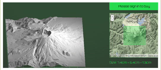
Move over Google Earth, now its possible to get 3D scale models for the terrain that you always liked – Grand Canyon, Alps, Cape of Good Hope? Well the choice is yours.
Mugs, tshirts are old; how about having a 3D model of the mountain you climbed? STRaND-1 – The smart phone controlled nanosatellite might have been the first satellite to have a 3D printed component, now thanks to Terrainator you can 3D print your terrain of choice.
Terrainator uses Google maps to help you select your favorite geographic area. Then creates an accurate scale model using DTM data complied from different sources including the USGS National Elevation Dataset. In comes the 3D printer, printing your terrain of choice as a scale model. Currently the models are scaled so that the base is 50cm by 50 cm but you can go in for a bigger model if you wish.
As of now only UK, Alps and parts of US are covered and also one can only print Digital terrain models which means you cant 3D print buildings or parts of a city. Dear Dan Wilson (the man behind this innovative idea) when can we print Buildings and parts of a city? Hopefully he is reading this!
The models are usually printed in sandstone. If you are flush with cash, a terrain model in Silver is the one for you 😉
Lets get printing shall we? here’s the link.