#Business #Ideas #Science

C3 Technologies – Google Earth killer?


C3 Technologies – company with its origin in the Swedish aerospace and defense company Saab AB, is now applying previously classified, military image processing technology to the development of 3D maps as a platform for new social and commercial applications. And the effect is astonishing especially knowing that according to the company its generated automatically. It is a very promising 3D data capturing and visualization solution for the navigation and geographic information systems industries.


How do they do that? 

C3 maps are assembled almost automatically using high resolution, spatial areal imaginary. So basically their planes are outfitted with photogrammetric cameras pointing every direction and capturing overlapping images. Knowing the GPS position, angles, rotation and distance between cameras their are able to almost automatically generate 3D, photo realistic, stereo-graphic view on a captured area.


Previously similar data could be captured by LiDAR – remote sensing technology that uses laser scanning to collect height or elevation data. LiDAR is however pretty expensive technology. We don’t know the initial costs of the C3 technology but it seems very cost effective in use. Google Earth from the other side involves using Google SketchUp 3D modeling. That means that people are almost manually putting parts of maps together which is is very time ineffective. 

Nokia OVI Maps 3D 

C3 Technologies has partnered Nokia to deliver the first usable version of its mapping data with Ovi Maps 3D in the begging of 2011. Currently it features 20 cities with limited functionality: pan, zoom, changing view angle. Company claims however to have 100 city models already produced with 22 more scheduled for Spring 2011. With this functionality its just a gadget to play and to check the possibilities of C3 technology. But does it mean that Nokia will use this data in OVI Maps? I am looking forward to here something about it.  

Google Earth killer?

Definitely not yet. The potential of Google Maps and Google Earth is not rooted in 3D view but in data that they have collected and interoperability with open standards (like KML). Row 3D without data about roads, streets, POIs ect. is not very useful.

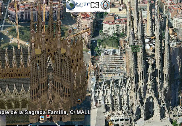
But let’s concentrate on 3D view itself and compare two products: Google Earth and Nokia Ovi Maps 3D. I order to do that I decided to choose Sagrada Família, one of the most architecturally sophisticated church in the world, situated in Barcelona, Spain, designed by Catalan architect Antoni Gaudí in early XX century.


We can observe that C3 model is much more photo realistic. Shadows and amount of details is really impressive. We can see however that automatically generated 3D geometrical objects like towers or rooftops of building on the second plan are not perfectly represented and Google Earth has advantage in this field. There is as well difference is representation of trees and ground details between two models. In Google Earth they are flat and in C3 they are convex, however not really well represented. 

I’m looking forward to see some more commercial applications of C3 3D maps and how they will develop. Both Google Earth and C3 models have their pros and cons. Maybe in a future we  will witness fusion of both technologies.


source:  C3 Techologies, Nokia OVI Maps 3D

Say thanks for this article (0)
The community is supported by:
Become a sponsor
#Business
#Business #Featured
Global Top 100 Geospatial Companies – 2024 Edition
Avatar for Muthukumar Kumar
Muthukumar Kumar 01.31.2024
AWESOME 10
#Business #Featured
Demystifying satellite data pricing: A comprehensive guide
Aleks Buczkowski 11.9.2023
AWESOME 6
#Business #People
Meet the founder: An interview with Chris Brown as Mapstack is awarded prestigious UK Innovation Smart Grant
Nikita Marwaha Kraetzig 11.2.2023
AWESOME 1
Next article
#Business #Ideas

Garmin to acquire Navigon


On Tuesday 14th of June, 2011 Garmin – one of the most popular sellers of navigation and smartphone GPS software – announced that Navigon’s shareholders have signed an agreement for a Garmin subsidiary to purchase Germany-based Navigon. “This acquisition is a great complement to Garmin’s existing automotive and mobile business. Navigon has invested significantly in the European automotive OEM business, and we feel that we can rapidly expand our automotive OEM footprint and capabilities through this transaction,” said Cliff Pemble, Garmin’s president and COO. “With Navigon, we are also acquiring one of the top-selling navigation applications for the iPhone and Android platforms – something that we expect will help drive revenue for the combined company going forward. Combining Navigon’s and Garmin’s strength also improves our competitiveness and standing particularly in Europe.” Garmin said that Navigon will continue to operate as a subsidiary of Garmin and that the deal is still subject to regulatory approvals.
A Garmin spokeswoman at the company’s Olathe headquarters declined to reveal what the company paid for Navigon, which is 90 percent owned by General Atlantic Partners, a private U.S. equity firm. Financial Times Deutschland reported this month that Garmin was considering paying more than $70 million.
Some analysts saw Navigon as a struggling company with just 5 percent to 7 percent of the European market. (It holds about 20 percent of the market in Germany.) By purchasing the company, Garmin perhaps saves Navigon and adds incrementally to its own sales in Europe. Garmin also was enticed by Navigon’s popular applications for iPhone and Android smartphones.
Garmin, Navigon and Dutch manufacturer TomTom, the European leader, have all seen their prospects hurt by the smartphone. Many consumers are forgoing purchases of handheld GPS devices and relying on applications in their phones instead. That has meant a shrinking market for GPS device makers, which have begun to battle for contracts to provide the devices built into the dashboards of cars and trucks. Garmin also has found rich markets in devices made for boaters, bicyclists and people looking to incorporate navigation into their athletic training regimens.
Navigon was founded in 1991, two years after Garmin. The German company’s first signature software product debuted in 1996 as Autopilot, later named AutoPilot 2000. The company continued as chiefly a maker of software until 2008, when it began to sell its own navigation devices. But the timing proved poor with the spread of navigation-enabled smartphones, and Navigon quickly pulled its devices from the U.S. market. Worldwide, Navigon has more than 400 employees. Garmin has about 7,000 workers and more than half the American GPS market. TomTom, its chief competitor, has just less than half the European market and a fourth of U.S. sales.

source: Engadet, The Kansas City Star
Read on
Search