
A few weeks ago, the world’s largest mobile industry event “The Mobile World Congress” showcased some interesting technology and inspired spirited discussions regarding the future of mobile technology. Technology has gone mobile and it is increasingly clear that geospatial innovations will involve mobile devices, a case in point being the surveying equipment that are connected to office servers which are already available in the market. High speed internet on Mobile devices is already something that has revolutionized the way we interact with each other and other devices; Automobiles and Home appliances have already taken the leap to a connected future “The Internet of Things”. The connected device concept is slowly starting to find its way into Smart Cities as well (geospatial technology for smart cities). Indoor Positioning and Marketing has never looked more promising with all these innovations and technologies at our disposal.
The latest thing to add more awesomeness to the Geospatial World is Augmented Reality. Remember the Google’s Augmented Navigation, Augmented Reality Motorcycle Helmet solutions? While those might be the most famous augmented reality device solutions, HERE City Lens and Wikitude are probably the best known examples of Geospatial Augmented Reality Applications.
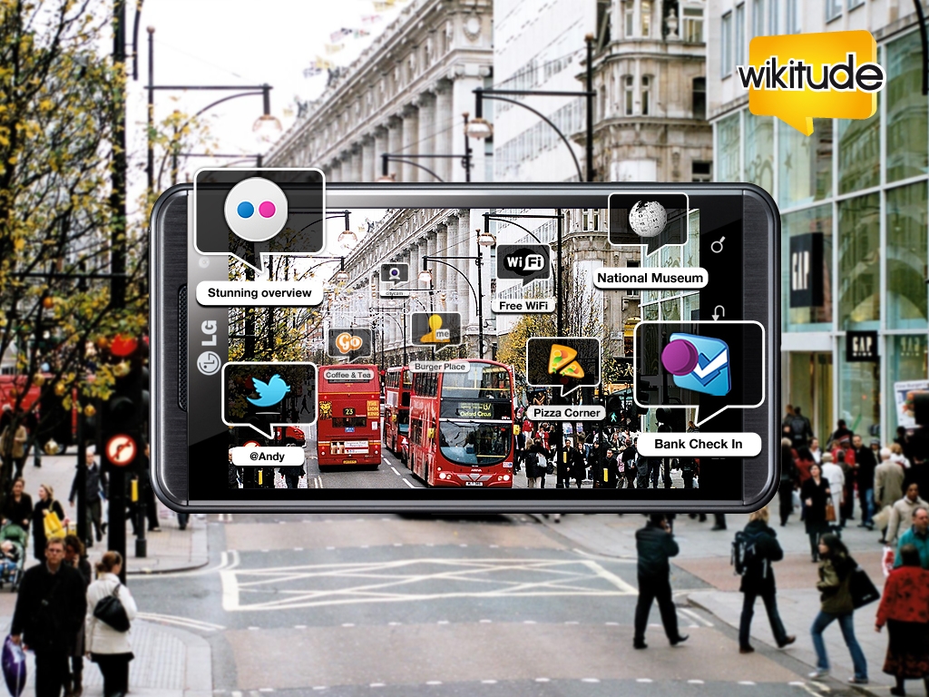
Conceptual these applications are pretty similar to Google Maps’ explore feature but then this is still a nascent stage in the development of geospatial augmented reality. The potential of Geospatial augmentation is enormous; this technology might just end up changing the way we look at Geospatial Marketing: Option 1: Send a text message when a customer enters the region near the supermarket with information regarding his/her product of interest or Option 2: Utilize augmented reality to change the whole scenario and make it more interesting. Wearable devices and Jackets are going to play a role in this as much as smartphones will.
It is almost certain that we would see some amazing geospatial augmented reality applications in the coming years. Combine SmartCities, Augmented Reality, Connected Cars, Internet of Things and Indoor Navigation – it is entirely possible that we might be driving around the city in a self-driven car with the Augmented Reality Navigation that informs us about the availability of a particular product in a supermarket and how exactly to navigate yourself once you are inside that supermarket!
Augmented Reality and Geospatial Technology: A match made in Marketing heaven 😉


#Business


Next article


One of things you look at when searching for a job is your commuting time. When you think about spending 4h per day in getting to work if might be discouraging, tiring and at the end it might have a negative impact on your motivation and productivity. The day has only 24h. If you spend 10h at work, 4h on commuting, 7h on sleeping, there is not much time left… for living.
The projects called “Access to Jobs Map” is focusing on that issue and mapping jobs in NY by commute time. The project uses Leaflet, Census data, public transit data in the GTFS format, and OpenTripPlanner to build this cool interactive map.
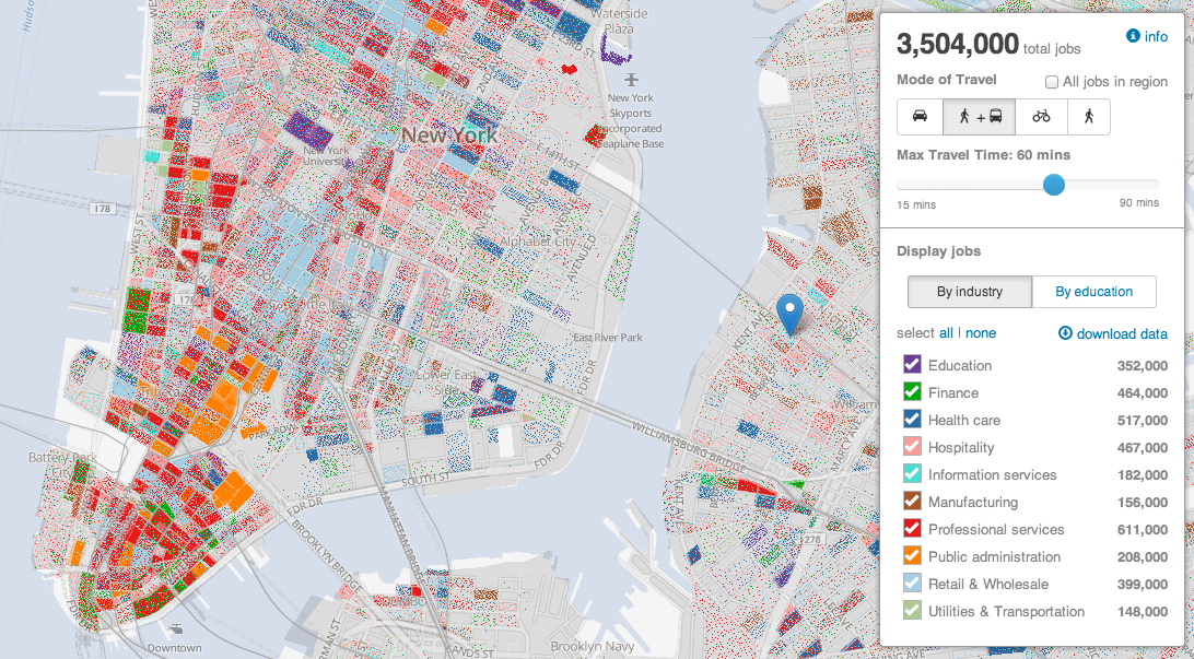
The tool allows the user to define the place of origin, mode of transportation (walking, biking, public transit or car) and maximum travel time. The map shows a single point for each job that meets the selected criteria. Jobs are colour coded by either industry classification or education of the employee wanted.
I must say that the map is simple but useful. Useful for both job seekers and employers who might use it for example to offer more flexible working hours or home office options for their employees. For me it also shows another cool map project developed with Leaflet. Cool stuff.