

Andre Dufour, GM, Amazon Location Service
On Dec 16, 2020, Amazon’s cloud platform Amazon Web Services (AWS) announced the preview launch of a new service that would give developers access to maps and location data on an economical, pay-as-you-go basis.
Today, as Amazon Location Service completes three months in public preview, it seems like a good idea to touch base with Andre Dufour, who quietly led the product management, engineering, business development, and UX teams for 18 months to bring this product to fruition.
Before taking on the role of General Manager for Amazon Location Service, Dufour acted as the GM for the AWS Orchestration Team, a group comprising three AWS services serving hundreds of thousands of cloud computing customers. It was there that Dufour learned customers were facing many obstacles when it came to integrating third-party location data into their applications.
“Current solutions require developers to compromise on issues including data security and privacy or are priced in a way that constrains innovation,” Dufour says, pointing that the feedback was many beneficial applications were not getting built because customers found the cost of location data prohibitive.
“We also heard that many customers found it tedious or difficult to integrate this data into their applications, requiring them to invest significant time learning the nuances of each provider and building their own tools for monitoring health and performance of an application.”
Now, at AWS, every decision to offer a new service or feature starts with identifying what the customers need and working backward. In fact, almost 90 percent of the AWS roadmap is driven by customer feedback. So, offering a solution that would make it easy and cost-effective for developers to add location data to applications in a secure manner became the next logical step.
“Since the service takes care of a lot of the undifferentiated heavy lifting, our customers are able to move applications from experimentation to production faster and focus on what matters most to their business,” Dufour explains, adding that lowering the barrier to entry also makes it much easier for those without any special geospatial expertise to quickly integrate location data into their applications.
“Historically, location data has been hard to work with and was viewed as a specialized discipline that required a GIS expert. More recently, we have seen the demand for location-based features become more pervasive for businesses and consumers,” observes Dufour. “Whether a customer is developing an asset tracking application or using location data to deliver more personalized experiences or marketing content to customers, we expect the need for location data will only increase.”
This is why it is crucial for Dufour and his team to ensure that their solution addresses the common pain points associated with other location-based service providers and opens up location-based capabilities to a much wider audience.
“Eventually, we see location data becoming a basic data type for all developers, and referencing to location tags will be as normal as referring to a timestamp for most developers. With Amazon Location, people without geospatial expertise will be able to implement a wide range of location-based capabilities into their applications as a natural extension of what they already do on AWS.”
Amazon Location Service leverages data from global technology giants Esri and HERE for a wide range of use cases, including building a delivery or ride-sharing application, tracking assets around the world, creating striking map-based visualizations, or integrating geomarketing capabilities into their workflows. But for Dufour, the advantages of associating with Amazon Location permeate beyond simple access to high-quality, cost-effective location-based services.
“Since Amazon Location is a fully managed AWS service, customers get the same benefits they have come to expect from AWS, including a commitment to data security and privacy, and the ability to scale and deploy globally,” the product leader emphasizes.
“And let’s not forget that the solution works right out of the box with many AWS services that customers are already using across their applications, such as built-in Amazon CloudWatch usage and performance metrics for application monitoring and integration with Amazon EventBridge for event-driven application architectures.”
Prod Dufour more on data privacy and he clarifies why security is billed as a top priority item at AWS. “We work with a wide range of customers from global banks to government institutions that insist on the highest standards when it comes to security, and we design everything from our physical infrastructure to our customer-facing services with this in mind,” Dufour tells. “So, one of the great things about AWS is that every customer benefits from these innovations, whether it is a global bank, a fast-growing startup, or a single developer building a new application.”
Recognizing the extremely sensitive nature of location data, Amazon Location Service has been designed to ensure that customers retain full control of their data – such as facility, asset, and personnel locations – and that data never leaves a customer’s AWS account (unless they choose to move it).
“Any queries sent to our data providers remove customer metadata and account information,” Dufour clarifies. “We take these precautions to ensure our customers can shield sensitive information from third parties, protect user privacy, and reduce an application’s security risks. Customer location data is never used to sell or target advertising.”
So, how has the early momentum been like for Amazon Location? “Extremely exciting,” Dufour quips with a smile. “The feedback we have received from customers will now help define our future roadmap and allow us to refine Amazon Location’s capabilities to better serve our customers in the future. Many customers have been able to realize cost savings by switching to Amazon Location, and some customers are even discovering new offerings or capabilities they could provide customers in the future.”
One of these customers is MobileLog, a service that helps businesses track and trace deliveries and vehicles in real-time. According to Dufour, MobileLog is on track to cut its development costs by 50 percent and achieve an overall cost reduction of 30 to 50 percent by consolidating their existing infrastructure to Amazon Location.
Then there is TensorIoT, an AWS Advanced Consulting Partner that creates solutions to help enterprises incorporate edge computing and data into daily operations to improve business outcomes. “Location data is a key aspect of many edge-computing deployments, but adding and using location data has been difficult for many of TensorIoT’s customers,” Dufour tells, explaining how Amazon Location has made it easier for TensorIoT to build custom solutions for customers and implement new features into some of their existing off-the-shelf solutions as well.
“Amazon Location is still in preview, but we have already seen tremendous interest from customers. In the months to come, we will continue to refine the service’s capabilities and make it even easier for customers with varying degrees of GIS experience to bring location-based features to their applications.”

#Business


Next article


It takes a lot of intelligence these days to understand all the apps, platforms, services that you need RIGHT NOW for your business to thrive. It is practically necessary to do some form of data analysis pertaining to your business in today’s world. Your ability to understand what factors affect your business will help you make quality decisions for productive results. In this article, we will explain what is the main difference between Business Intelligence and Location Intelligence.
Understanding your business’s spatial dynamics and how it affects your business requires a lot of data. It would help if you had the right combination of tools to help you understand these data and interpret what it means for your business. The intersection between how location impacts your business and how your business may impact your location is where Location Intelligence and Business Intelligence come to play.
Data analysis and interpretation don’t have to be complex. Either you’re using a simple tool like Excel or a more sophisticated tool like Tableau or Gooddata to help you gain crucial insights to making business intelligent decisions.
Today, there is increasing data availability, and there’s a need to narrow down to the specifics on how it’s interpreted to make business decisions. That’s why it is essential to analyze data through the context of location. In that case, here’s where Location Intelligence (LI) and its tools come into play.
Just as supply is vital to demand, so is the demand for data analysis as data supply grows. There’s a need to understand why and how specific business interactions happen, which we can interpret as Business Intelligence. Understanding why things occur where they do is Location Intelligence. These interactions could grow from simple to complex; hence the need for Business Intelligence and especially Location Intelligence tools increases.
Let’s see the main differences between the two disciplines and how BI and LI can get along with each other to get the most out of your data. We will show you how it works on a real example.
To demonstrate the differences between BI and LI, we have chosen one tool from each; Tableau represents the team Business Intelligence, and CleverMaps stands for the Location Intelligence team.
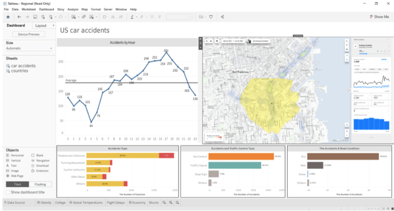
The showcase project is Traffic accidents in the US.
The Business Intelligence approach: Know your numbers
With the aid of a business intelligence tool, you can easily visualize your data and draw a meaningful inference that will help you gain productive results. They allow you to integrate or import data from multiple sources, computing and visualizing them for your understanding in real-time.
The good thing about it is that anyone on your team can process the outputs, and even if you are not tech-savvy, you’ll find some of the visualizations pretty handy without being bored with all of the technical jargon.
For instance, BI tools like Gooddata, Tableau and Power BI will show you data trends. Imagine running a Unisex footwear e-commerce store, and your data reveals that you have more females buying from you than males. Then you’ve got powerful insight for your business on your hands. You can do many things with this information; you might want to observe why only females are buying and probably retarget your Ads for males. Or maybe it is females who are buying the shoes for males. Such is BI tools’ power, and there are ample resources to help you make effective business decisions.
Such is BI tools’ power, and there are ample resources to help you make effective business decisions.
BI tools can also help you generate predictive analyses for your decision-making. It allows you to understand what your dataset means and probable outcomes from such trends in the near future. With this information, you can predict how your decisions will impact your current business standing.
Some BI tools also have some possibility to visualize your data on a map. For example, in Tableau, we can visualize the traffic accident data set for the whole USA. With that, we know many accidents occur in each state or city. There is also a possibility to visualize the accidents as points on the map, but there are limitations to advanced work with the map.

With BI, you understand why specific (business) interactions occur, but Location Intelligence is the way to go when you need to know why they appear.
The Location Intelligence approach: Understand the context
The need for a Location Intelligence tool comes to play when the spatial relationship becomes an essential component of business success. This concerns businesses such as banks, insurance companies, retailers, and delivery services; in a nutshell, any business with its customer touchpoints, pickup points, or any other establishments.
For instance, a bank will concern itself with proximity to customers and a competitive environment in the area rather than a company that virtually offers its services. You might also want to understand other spatial factors like transportation, housing configurations, or if the location is commercial or residential, depending on how it relates to your business.
All of these insights can be easily available to you in Location Intelligence tools like CleverMaps or Carto. With LI tools, you will be able to reveal the essential spatial context for your decisions. Seeing a potential location for your new customer touchpoint or pick up point physically, in Tableau or in Google Maps is great. Still, it won’t tell you the possible customer base size, competition, POIs around a certain walking distance, catchment areas, human mobility and other essential factors.
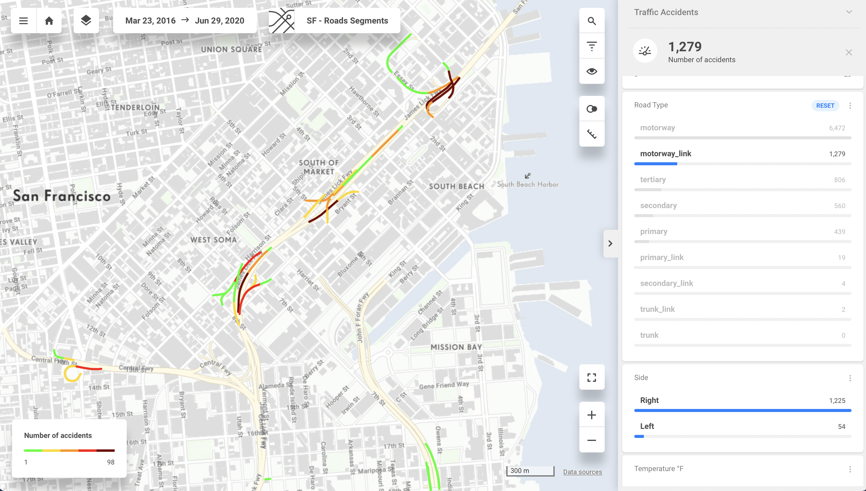
Let’s see Location Intelligence in action on our Traffic Accidents example. Some locations have more accidents than others. It might be because of a confusing intersection, wrongly placed traffic signs, or a sharp turn. These are the factors Business Intelligence won’t tell you. Using Location Intelligence will reveal the critical context for your decisions no matter if you want to prevent traffic accidents or decide where to place your new shop.

Now we know what road segments are prone to accidents, as well as what areas to focus on. Some of the Location Intelligence tools (for example, CleverMaps) allow us to discover the location even further by changing the map base layer. Thanks to this feature, we can guess what is causing the problem.
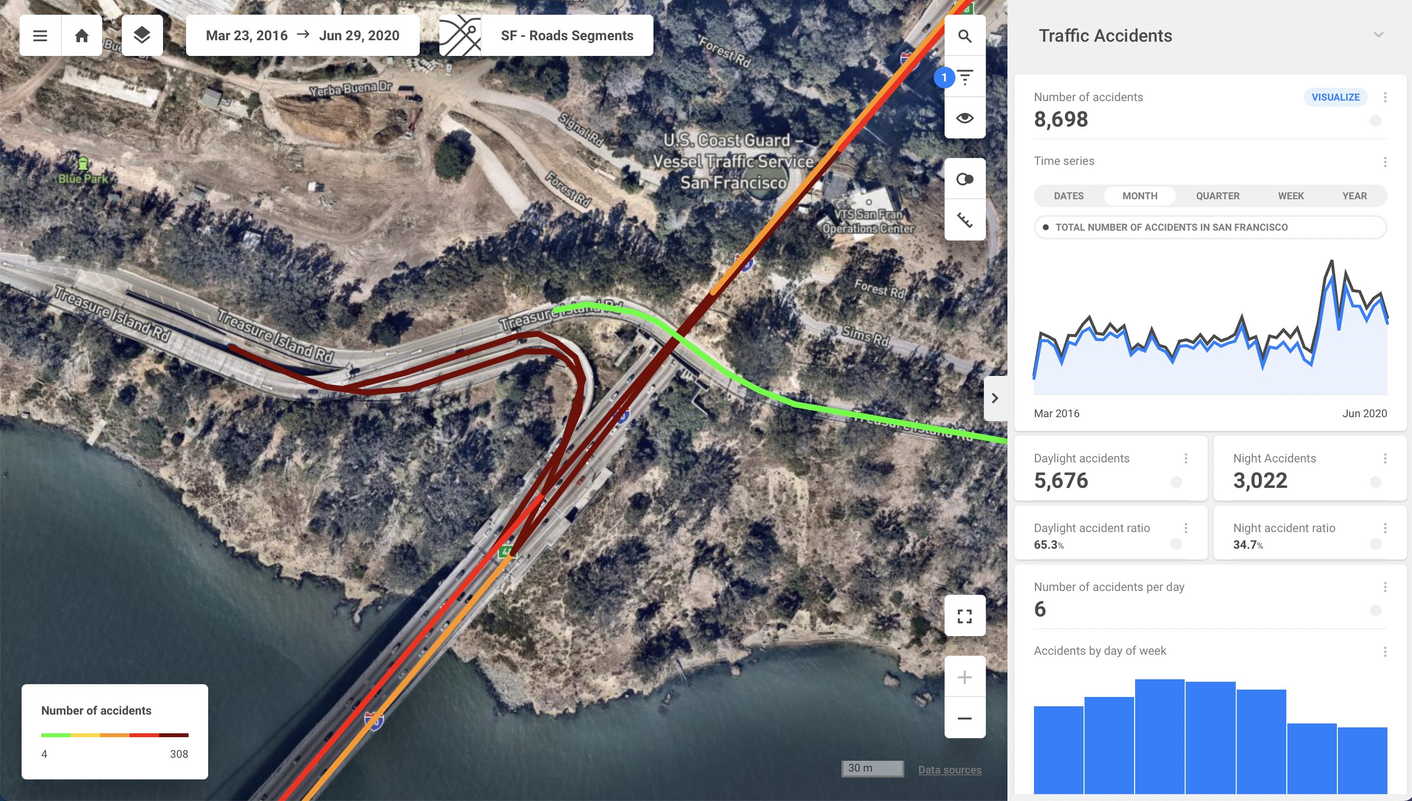
This is not where the fun ends. Location Intelligence in CleverMaps allows us to easily combine more datasets to get the context of the data. In this case, we have a dataset of the traffic accidents combined with the dataset of types of roads. Each dataset includes coordinates which are placing the accidents to concrete locations and allows us to analyse further where and why the traffic accidents are happening.
Each approach has its purpose
Well, let’s sum this up. Business Intelligence and Location Intelligence have their place in modern analytics and can be beneficial for your business. However, it is essential to remember that each of them has a difference in usage.
With Business Intelligence, you are getting all your numbers on a silver platter. You see the trends in data, and you can predict the future development based on the trends. All in a very user-friendly and graphically convenient way.
With locational Intelligence, you take things to a more spatial context. You can see what’s going on around you and how it’s impacting your business. It’s also easier to understand why you are not getting clients from specific locations, see why one of your sites is performing better than another, keep track of competition and so on. This is what could be challenging to find out in BI. With LI tools, you can narrow it down to observe locational dynamics and how it all impacts your business.
You might need one of the LI mentioned above tools integrated into your BI tool to help you uncover new grounds to cover for your Business. For example, Tableau and CleverMaps are fully compatible. With LI and BI, you’re entering a new world of analytics possibilities!