

Addresses are a ubiquitous part of our daily lives: they serve as the backdrop to every place we go, every item we order online, and every service we register for. As a result, we take them for granted, rarely thinking much about their many vital uses—or how they have come about. More than just sequences of numbers and letters designed to guide mail delivery, addresses are a complex interweaving of human and physical geography; through urban layouts and street names they tell stories of cities, towns, and the natural environment, but also of societal structures, conflicts, and change.
These rich stories have created a complex web of diverse and dynamic data. But in our increasingly interconnected global economy, having an accurate and reliable address system has never been more important—both in the digital and physical world. When an individual provides an organization with their address, for example by typing it into a multi-field form online, the organization needs to be able to validate that data: to check it is ‘deliverable’ and to understand its location. Our traditional system of assigning addresses is struggling to keep pace.
Enter Geo Addressing. To put it simply Geo Addressing is “bringing accuracy, consistency and context to addressing data, in other words, data integrity for addresses. However, the process is not without its challenges, and it’s a field that requires us to confront the diversity and dynamism of our world head-on. Our ‘Geo Addressing Decoded’ series will look at the importance of accurate address systems, the challenges, some of the innovative solutions being developed and their many applications. In this first article, we will start by looking in detail at the challenges presented by the traditional addressing system and conventional datasets.
The Dynamic Address: A Global Challenge
In his “Addressing What Matters” series, Mike Ashmore – Sr. Director of Product Management at Precisely, highlights the fact that addresses are dynamic entities, subject to change due to urban development, political shifts, or administrative refinements. In the UK, for instance, an astonishing 4.5% of addresses underwent a change last year. Many of these were minor, such as spelling corrections, but the alteration of even a single character can create duplicates in a digital address database. In a more striking case, the municipal restructuring of Quebec in the early 2000s incorporated many outlying towns into the new Quebec City, resulting in 922 duplicate street names. To avoid confusion for postal and emergency services, many of them were subsequently renamed, creating additional complications.
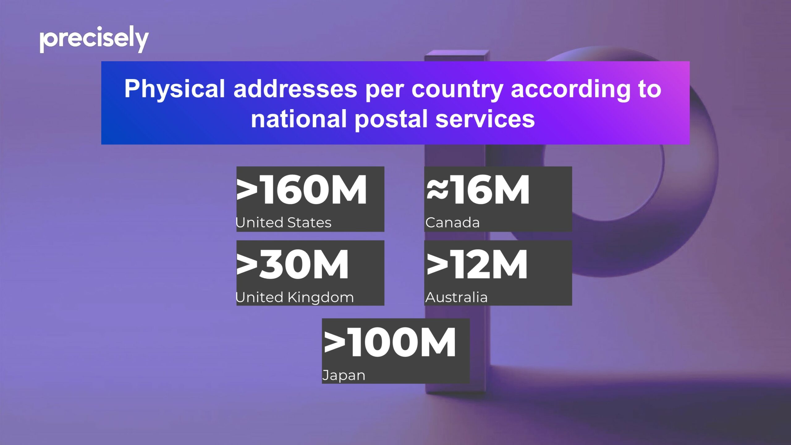
Why Does Geo Addressing Matter? – Amount of addresses around the world
To take another example, in 2017, a re-survey of the border between North and South Carolina led to a tweak in the official state boundary, which, although tiny on a global scale, led to dozens of properties technically moving from one state to the other, with legal and financial repercussions. And on the most extreme end of the scale, there are plenty of examples of entire countries changing their names, either due to conflicts or due to a rejection of a colonial past (like eSwatini, formerly Swaziland), something that address systems need to accommodate.
There can also be huge diversity in addressing systems around the world, with some unique methods of allocating addresses. In Colombia, for instance, addresses are based on a grid system, with a structured code indicating the street and the distance in meters from the nearest junction. Japanese addresses, by contrast, are based on areas, from big to small (prefecture, county, town, neighbourhood, block, apartment). In New York, there is a common practice of ‘co-naming’ streets for political or sentimental reasons, and as a result something like 2,000 streets have both a formal and an honorific name, only one of which is recognised by postal services.
Furthermore, nearly half the world’s population lacks a formal address entirely! This problem persists not only in developing countries, where ‘descriptive’ addresses are common, but even in rural areas of developed nations like the United States.
An Inconsistent and Incomplete System
It’s a challenging landscape, but organizations need accurate address data, whether they are delivering goods, providing services, or gathering information about a property. Unfortunately, in addition to the complications outlined above, collecting that data is also a challenge due a lack of definitive sources.
Postal services, where they exist, offer one of the most reliable sources of address data, but even they have their limitations. Not every legitimate location receives direct delivery from the postal service. On the other hand, not every postal delivery point translates directly to a physical location: A PO box address is really an instruction to the post office to hold mail for the receiver; a military vessel at sea will technically have an address, but it won’t tell you where the ship physically is. To take a more everyday example, in a large apartment block, mail may be delivered to individual mailboxes in a communal area, so the delivery point does not correspond to the physical location of the property.
This highlights a broader point: the existence of an address does not necessarily mean its location is known—or understood. This is notable in the case of new developments, where it is normal for addresses to be assigned to a location during the planning stage of a development, before the physical infrastructure actually exists, creating a temporary discrepancy between the address on paper and physical reality.
The factors above give an impression of the difficulty faced by any business or organization which uses address data. They are left with inconsistent, incomplete data, and a continuous battle to keep it up to date with ‘ground truth’.
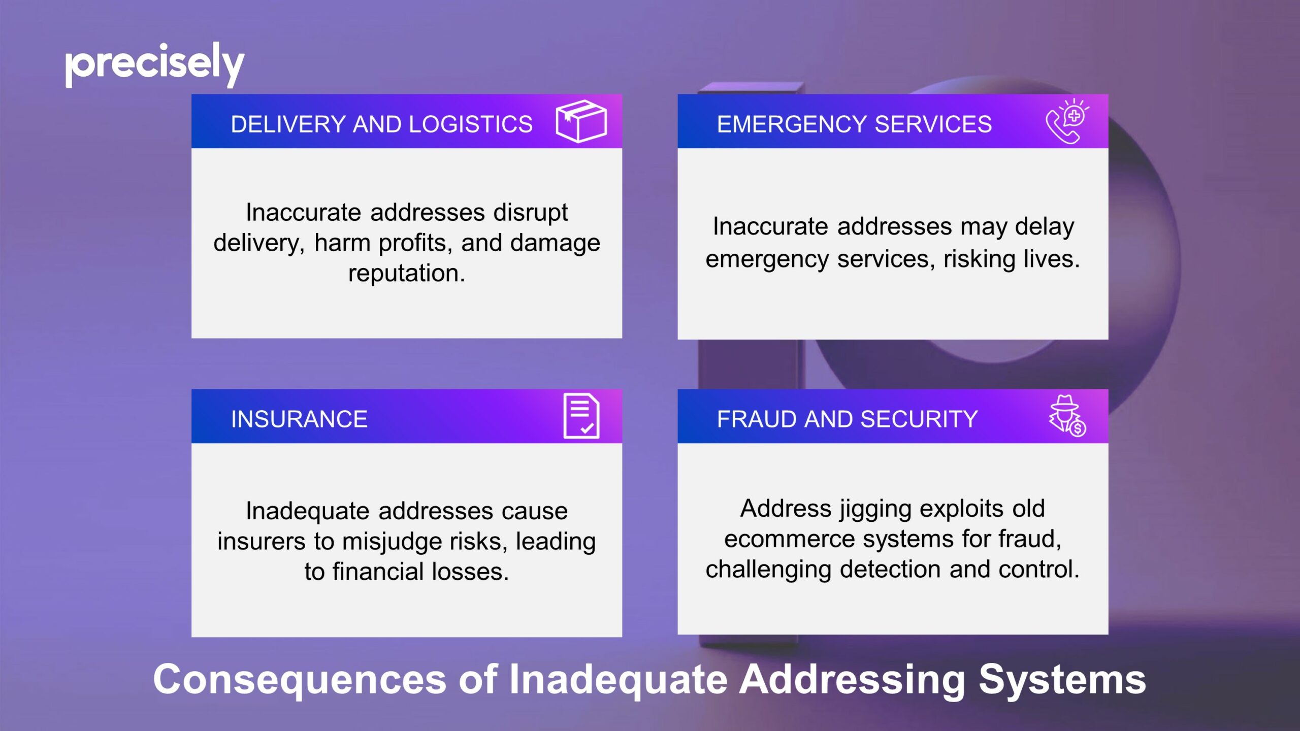
Consequences of Inadequate Addressing Systems
The impact of inadequate addressing systems extends across many different sectors, each of which experiences unique challenges.
- Delivery and Logistics: For companies shipping goods, bad address data can break down the entire delivery chain. Incorrect addresses can cause delays, failed deliveries and, at worst, lost packages, which all result in a direct hit to businesses’ profits and reputation. With an increase in same-day delivery and automated ecommerce systems, the accuracy of address systems is more crucial than ever.
- Emergency Services: Emergency services rely on precise and quick location identification to provide timely assistance during crises. When addresses are incorrect or incomplete, response times can be significantly delayed, with potentially devastating consequences. Accurate addressing can literally be the difference between life and death.
- Insurance: Perhaps less obvious, but inaccurate addressing also spells trouble for insurance companies. Precision is key for insurers to properly evaluate risks: If they misjudge a property’s location due to bad address data, they might set premiums too low for high-risk areas, which can lead to significant losses during events like natural disasters.
- Fraud and security: Address jigging, a fraud tactic that involves subtly altering shipping addresses to exploit ecommerce vulnerabilities, initially emerged among sneaker enthusiasts. It allows a buyer to circumnavigate ‘one-per-customer’ deals, enabling them to secure large quantities of valuable items or free samples, from drugs to electronics. The technique has evolved, powered by sophisticated bots, and detecting such activities and catching the perpetrators can be a complicated process. Address jigging only works because many ecommerce companies are using old-fashioned address systems.
Why Does Geo Addressing Matter? – Impact for sectors of life
The Path Forward: A Future of Precise Addressing
The examples above point to the ongoing need for improvements in addressing solutions to accommodate the needs of a globalized economy and the expectations of consumers and businesses alike. Our traditional system of assigning addresses is struggling to keep up. As we navigate the complexities of our increasingly interconnected world, the importance of developing and implementing advanced addressing solutions cannot be overstated.
Thankfully, innovative technologies are now here, promising to make every address accurate and easily findable, and paving the way for a future where accurate, reliable, and universally accessible addresses are a given. The next article in this series will delve deeper into the future of address systems and the technological solutions ensuring no one is left off the map.
In the meantime, consider the addresses that populate your life—the places you call home or work, or choose to visit. Each carries a story, a set of data, and a link to the wider world, underscoring the profound impact of addresses on our collective and individual experiences. Beyond their practical utility for navigation, they are a fundamental part of our identity.
About Precisely
Precisely is a global leader in data integrity, providing 12,000 customers in more than 100 countries, including 99 of the Fortune 100, with accuracy, consistency, and context in their data. Precisely’s data integration, data quality, data governance, location intelligence and data enrichment products enable better business decisions to drive better results. Learn more at www.precisely.com
![]()
Did you like the article about Geo Addressing? Read more and subscribe to our monthly newsletter!

#Business


Next article

LiDAR technology, with its precision and versatility, has become a critical tool in environment monitoring, particularly for tracking and analyzing landslides. This technology offers a way to capture detailed three-dimensional data of the Earth’s surface, making it an invaluable asset in understanding and mitigating the risks associated with landslides.
How to acquire LiDAR datasets?
A rich in data resources for those looking to utilize LiDAR data is Open Topography, an open-source platform that hosts a wealth of datasets ready for download and processing. This platform exemplifies the growing trend towards accessible, high-quality environmental data, empowering researchers and professionals to conduct in-depth analyses with global reach.
Open Topography stands out not only as a repository for LiDAR datasets but also for its integrated tools that allow users to process and analyze LiDAR data directly on the platform. One of the most valuable features is the Differencing processing tool, enabling users to easily compare different LiDAR datasets over the same area. This functionality is particularly useful for monitoring changes in the landscape, such as erosion, vegetation growth, or, notably, landslide movements.
Results of Differencing Job in Open Topography service
Landslides in New Zeland
New Zealand, with its dynamic landscape, frequently experiences landslides that can cause significant disruption and damage to infrastructure, such as main roads. One notable instance occurred near the city of Gisborne, where a landslide had a profound impact on the local community and infrastructure. GNS Science, a geoscience research institution in New Zealand, offers a service through its database on landslides within the country. This database is an essential resource for understanding the frequency, distribution, and characteristics of landslides across New Zealand’s diverse landscapes. By providing detailed information on past and present landslide events.
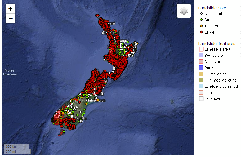
Landslides Map. Source: GNS Science
Case-study: landslide monitoring in Gisborne
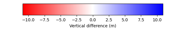
In this case study, LiDAR data’s classification feature proved invaluable, allowing for the separation of ground points and a detailed analysis of the terrain changes over time. To receive a visualization of significant changes on the slope there were applied two algorithms in Cloud Compare software. The first one was connected with calculating the distance between two pointclouds from two periods of time: 2019 and 2023. Second method was employing the M3C2 algorithm. Both methods were able to generate a map highlighting significant changes in the landscape, offering critical insights into landslide dynamics. What is important about the M3C2 algorithm is the fact that it’s possible to receive information about distance uncertainty. In Gisborne case study accuracy of the resulting ground movement was up to 40 cm.
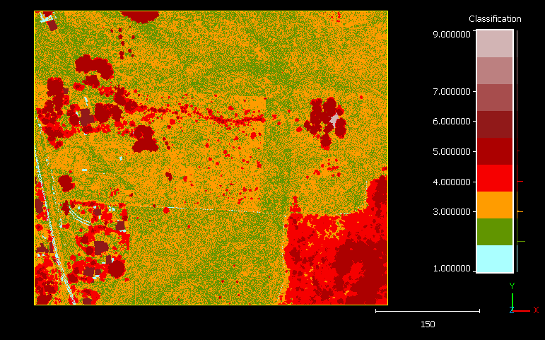
Case-study. Classification map
Case-study. Algorithms comparison
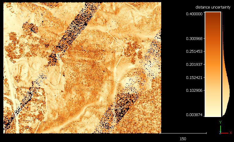
Case-study. Distance uncertainty
Landslide Monitoring on the West Coast of New Zealand: A Case Study at Te Toto Gorge
Another example of LiDAR’s application in cliffs monitoring is found in the Te Toto Gorge walking trail near Raglan, New Zealand. Here, LiDAR point clouds were converted into a mesh, and by computing mesh-to-mesh distances, it was possible to detect subtle shifts at the edges of cliffs. This approach provided a nuanced understanding of the cliff’s behavior in the period of time: 2015 and 2021. For instance, which edges are more unstable or where accumulation of rock layers takes place.
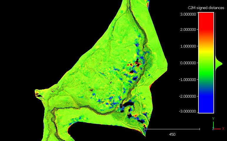
Case-study. Mesh to mesh distances – top view
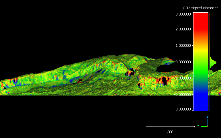
Case-study. Mesh to mesh distances – front view
In conclusion
The case studies from New Zealand underscore the profound impact of landslides on communities and the environment. They also highlight the effectiveness of LiDAR technology in monitoring these events. The ability to classify points and analyze changes between different datasets allows for a detailed understanding of landslide progression and potential risk areas.
Moreover, these examples emphasize the importance of cyclic measurements. Regular, systematic data collection is essential for maintaining up-to-date and accurate models of the Earth’s surface, enabling timely responses to landslide risks. As the accessibility of LiDAR data continues to improve, with resources like Open Topography, the potential for proactive environmental monitoring and disaster mitigation grows, offering hope for more resilient communities and landscapes.
Did you like the article? Read more and subscribe to our monthly newsletter!