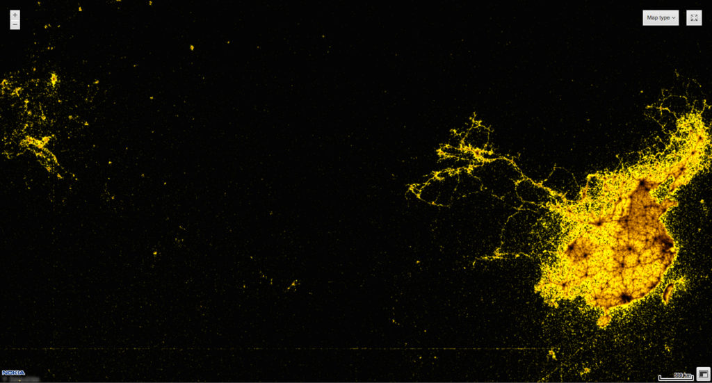
This Map By Nokia Shows All Windows Phones With Language Set To “Chinese” In Asia And Europe.

Companies owns a lot of Big Data about their business and their customers. More and more they start to realize that and use it in their advantage. This particular map made by Nokia HERE in Berlin shows spatial distribution of all Windows Phones with language set to “Chinese”. With market penetration close to 10% on average worldwide this map gives you good estimation on what is the density of Chinese people around Eurasia, which particularly interesting outside China. Any census data or migration office will not be able to show it and definitely not on such a scale.
From the perspective of Nokia such a tool can actually give them value of real market penetration and how it spatially changes over time. I bet that 1 year earlier this map looked totally different. This can be particularly interesting after the launch of a new Lumia with availability in different countries at different time and can clearly answer whether marketing activities were appropriate. New customers would be simply lighting up on the map. I’ve been working with location-based big data for some time already and I’m more and more fascinated by the possibilities it gives and how companies and governments could use it.
source: Nokia Conversations

#Business

Next article


I have been a cartographer for over 25 years and have had my private pilot’s licence for much of that time. The view of the pilot and the view of the cartographer are very similar. We are both looking down on the earth from a great height, trying to visually interpret what is on the ground and how it all connects together on our map. The order in which we, the pilot and cartographer, do things is often very similar, in that we are looking at the earth to transfer or locate the information onto or on our map.
The way our brain interprets the information can be different from person to person and from situation to situation. The pilot is using the visual information to navigate from A to B while the cartographer is trying to represent what is on the ground so the users of the map can do the same as the pilot, get from A to B. The symbology used by one cartographer may be great for their map but be totally inappropriate for others.
Flying and Cartography – what do they have in common?
If a pilot makes an error in the interpretation between their map and what they see on the ground, the consequences could be dire. If you think about it, if the cartography interprets what is on the ground incorrectly and depicts it on the map wrongly, the consequences could be dire as well. There have been many reported incidents of GPS navigation devices sending unwitting tourists on a trip they did not need to have, the same can be said for what the cartographer puts on their map, how it is displayed and the symbology used.
The way aeronautical charts have been put together have remained largely unchanged for a long time, although they are updated on a very regular basis to ensure that pilots are using the latest information available. On the other hand many standard topographic maps are only updated when needed. Many people assume what they are viewing is up-to-date, both in a digital view and a hard copy. As soon as any data is published it is out of date and it is up to the user to ensure the maps they are using are fit for purpose. We have all become reliant on navigation tools using Goggle Maps or similar but have you stopped to take note of when it was last updated.
More and more pilots are taking advantage of technology i.e. GPS devices with moving maps. I am certainly one who likes technology both as a cartographer and a pilot, but in both vocations we need to be aware not to place too much reliance on the technology. It is mandatory for a pilot to know how to navigate without the use of technology, just in case it fails. It is also my opinion that cartographers of today need to know the underlying reasons behind maps and the way we put them together.
Stop and take a few minutes to understand the maps you are using and why you are using them and what the intention of the map is. If it is not fit for the purpose you are about to use it, then maybe think twice, especially if you are about to take off at your local aerodrome.
—
Network with other Geospatial Professionals
Join GeospatialConnect network today!
www.geospatialconnect.com