
For us geo-nerds, it is important to visualise where events are happening when we read about them. It is especially easy to get disoriented when we are reading about a fictional world that we have ju
st immersed ourselves into. Sure, you can always flip to the beginning of the book to look at the map but that would take you away from the story! If reading historical fiction about the real world, it would be easier to visualise and understand the geographic complexities because we’ve known about real world geography for a longer period time. It’s a good thing that we now have a tool to visualise Westeros.
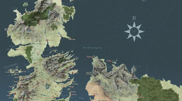
Fans of the successful series Game of Thrones have gathered to create a Google Maps style interface for users to explore. It is highly interactive and possibly addicting. Find it here.
From political boundaries to character plot lines, you can easily do your own spatial analysis of this complex world and see simultaneous events. You can follow your favourite character geographically on their journeys. Worried about spoilers? It allows you to see the maps episode by episode so nothing will be ruined for you! But nothing is stopping you from taking a peek…
Now, the only thing lacking is Streetview!
Do you think this will help you better understand the world of Westeros? What other fictional worlds would you like to see on this kind of interface?


#Ideas


Next article
One of the reasons why I love to travel is so that I can learn about a city and what makes it special. I want to immerse myself into the local culture and maybe even get away from some tourists. I also want to know about people’s way of life, where they eat, what they do for fun… it’s quite difficult to know all of that unless you know a local. By planning your travels around websites like Tripadvisor or Yelp, you would inevitably go to places where all of the other tourists go and pay a hefty price for a mediocre experience. Restaurants and tourist attractions also pay Google to show up in the primary results when you do a simple search. This leaves many travellers in frustration and dissatisfaction.
How else would you plan your travels, you ask. You don’t even know the place!
I encountered my first USE-IT Europe map when I visited Porto in Portugal. It’s not just a map, but it tells you everything a young tourist would want to know; the history of the city, how to act like a local, how to get around, when and where to get a good deal, and even some walking tour routes. Best of all, it’s all made by local volunteers! They are currently in about 33 cities in Europe and are growing.
What I love about these maps is that they give great advice. They are free and don’t contain any advertisements so you know that their recommendations are fair. The volunteers go through great lengths to ensure that the information is up to date at the time of publishing. The maps are visually stunning works of art and I regret not keeping them after my travels! Usually, you would only be able to pick up a paper copy at a hostel.
But now that we are in the age of smartphone navigation, USE-IT is trying to get funds to create mobile apps for these maps! The app will be completely free and users will be able to download maps for offline use. So if you have used a USE-IT map yourself and would like to support them, donate here.
An app like this definitely has a lot of potential. These are some things I would personally like to see:
-A map that allows users to enable their GPS so that they can navigate around the city with it, rather than having to switch between this and Google Maps
-Audio for their walking tours
-Audio with the local language and accents
-An interface that allows users to add ratings and reviews
Are there any map-related travel apps that you use? What other features do you think would be useful for this app?