
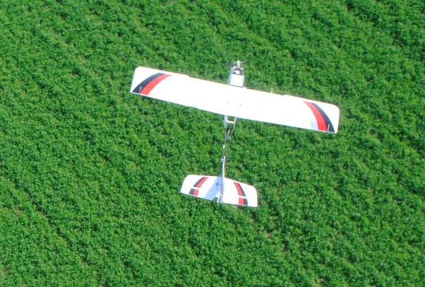
 In farming, this principle is vital. The illustration below shows how a visual sensor on PrecisionHawk’s UAV platform can identify pests, like weeds, from the air at crucial points in the growing season. During the early stages just after seeding, farmers have to make decisions about their weed control. With the ability to determine, from an aerial view, exactly where the weeds lie, a farmer can perform specific spot applications to the affected area saving time and money.
Weed detection is carried out by determining the height or profile of anomalies across plots. Crops are generally of uniform heights, so sudden dips or peaks in the profile denote the potential presence of weeds.
The picture above shows a 3D rendered image of a plot in question. The red line points out the part of the plot that is being analyzed. The profile of that line is displayed in the bottom left image. As you can see, there is a sudden gap and peak in the profile. This anomaly indicates the presence of weeds. The only way to spot weeds is to visually inspect if they are present. For farmers who own large fields, this is time consuming–and time is an expensive commodity. The use of a UAV allows for the quick and frequent visualization of fields and consequent analysis through anomaly detection to immediately identify areas where weeds are prevalent. This addresses the problem by (1) immediately identifying weeded areas and (2) allowing the farmer to act in a targeted manner.

Today, UAVs cannot completely eliminate field scouting, but the ability to monitor specific areas and visit geo-referenced plots across many acres is invaluable. However, we do envision a time when UAVs will replace field scouting entirely and humans will never even see collected data. The data will run from the UAV into the tractor for spot application at the problem areas across a field. It’s the future. Decrease time and inputs and increase efficiency to enhance outputs.
What actions are farmers currently taking to resolve the existing problem around weeds?
There are approximately 8,000 species of weeds and most of them affect the farming industry. They reduce crop yield by competing for water, light, soil nutrients, and space. Other problems associated with weeds in agriculture include: reduced crop quality by contaminating the commodity; interference with harvest; serve as hosts for crop diseases or provide shelter for insects to overwinter; and production of chemical substances which are toxic to crop plants, animals, or humans.
Weeds are common on all 485 million acres of U.S. cropland and almost one billion acres of range and pasture. Due to the commonality, people generally do not understand their economic impact on crop losses and control costs. In estimation, U.S. farmers annually spend $3.6 billion on chemical weed control and $2.6 billion for cultural and other methods of control.
UAV platforms carrying remote sensing technology such as can cost-effectively and efficiently solve many basic agricultural problems, like weed control. These technology tools support better decision-making allowing a user to identify problems while they are still manageable and before they get out of control.
UAVs are now widely being used across farms globally. Coming to a farm near you.


#Business


Next article

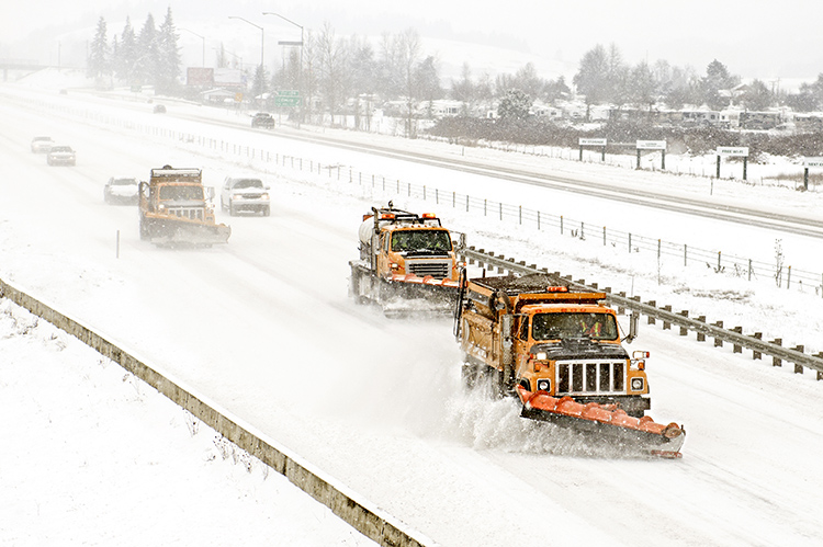
Many local governments in areas that get regular snowfall maintain a fleet of snow plows. In the winter season, speed and efficiency of snow plow fleet are of a great importance – especially in highly urbanized cities. We bring you a case study showing how to make a snow fleet management system more efficient with a simple software solution, featuring a story coming from the City of Zagreb.
PROJECT INFO
City of Zagreb is the capital of Croatia. As the climate of Zagreb is moderate continental with hot summers and cold winters, during winter season, snowfall is a common occurrence. This causes various traffic difficulties. That is why it was important for the City of Zagreb to have a solution for effective management of their snow plow trucks fleet.
What were the challenges?
City of Zagreb wanted to replace an outdated fleet management workflow that was slowing the decision making process during snow emergencies because they didn’t have an overview of the situation on the streets and the cleaning progress in real time. The decision making process was complicated by the fact that City of Zagreb officials needed to manage multiple subcontractors from one account. They wanted to have a possibility of having a full control of vehicles and their expenses on a daily basis. This data should be available on a map accessible by multiple users, both in the office and in the field, using different devices. Considering the fact that mapping data consists of larger datasets and contains a lot of information, the challenge was to have a fast solution with an optimal loading speed. City of Zagreb needed to make their snow emergency response faster, better and more efficient.
At the same time, they wanted to improve their daily workflow and reporting process, and be able to create custom reports with accurate data updated in real time.
What was the solution?
In a need of a more ‘up to date’ approach, City of Zagreb adopted and deployed GIS Cloud tools for their winter fleet management. Cloud based GIS turned out to be a necessity for a successful coordination between multiple users, contractors, and on multiple devices in a real time. Also, cloud GIS made their reaction time faster and workflow more efficient because they were able to track and monitor the progress of snow removal process while making decisions on site.
In order to use their existing data, an integration between Map Editor and Fleet and Workforce Management apps was achieved.
As a powerful mapping tool, Map Editor enabled publishing of existing data, editing and labeling, as well as managing and sorting the data in corresponding folders. The idea was to divide a given area (city of Zagreb) in multiple tasks, where each task represents a group of streets. Their mapping effort would then be connected to the GIS Cloud Fleet and Workforce Management solution, giving the each unit their assigned task.
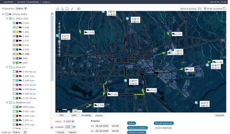
An overview of vehicle consumption is possible in Fleet and Workforce Management app so this way City of Zagreb has a full control of managing different types of costs (i.e. salt and other means for defrosting). This enables cost assessments for future, giving them information on what can be reduced and for which subcontractor in particular.
With GIS Cloud Fleet and Workforce Management Solution, real time coordination between drivers and dispatchers was accomplished, having an overview of driver’s locations at any time. This real time solution, enabled a faster response time and more effective decision making in critical situations. With customization options, set of various reports could be made like mileage, fuel consumption, speed limitation etc.
As a novelty, a system for early ice detection was incorporated, where multiple sensors are tracking different criteria like air and pavement temperature, humidity etc. Once a given threshold is crossed, this integrated system in Fleet and Workforce Management app will notify the dispatcher, giving him the necessary information for effective decision making.
GIS Cloud Fleet and Workforce Management Solution was ideal for City of Zagreb, as it accelerated the outdated workflow by using and customizing existing GIS Cloud applications. Real time vehicle tracking was enabled by using fast and responsive maps and by making the decision process inter-operable. With decreased response time, severe winter conditions became much more manageable.
To sum it up, these were the results:
- Integration between Map Editor and Fleet and Workforce Management (overlap between fleet and their own data)
- Vehicle Tracking in real time (monitoring of the status and path that certain vehicle has passed)
- Report about every vehicle regarding the beginning and ending of the drive, time, miles, fuel consumption, speed limitation, status of the vehicle
- Real time collaboration between the driver and the dispatcher
- System for early detection of ice on the pavements (17 sensors over the city reports current status of the pavements regarding the temperature of pavement and air, humidity of the pavements and the freezing point which depends on rainfall, fog and salinity of pavement)