


Today Google released a new version of Google Earth (version 9). Unfortunately, it’s not a new standalone desktop app. This version is again designed to run in a Web browser (limited to Chrome). There is also a new Android app (and iOS coming soon).
The new version features a couple of cool improvements including destination discovery, knowledge cards and much better 3D navigation. Additionally, Google Earth now suggest “Points of Interest” it thinks the users will like based on what they have searched for in the past.
But the biggest new selling points are interactive tours. This feature is called ‘Voyager’ and it enables people to take interactive journeys guided by experienced scientists and documentarians from BBC Earth, NASA, Sesame Street, and the Jane Goodall Institute.
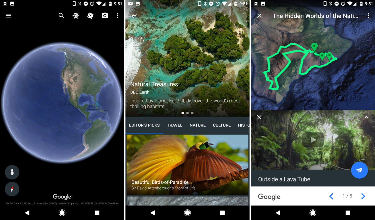
This new released is really cool but I’m a bit disappointed that there is no update to the Google Earth Pro desktop app which is still stuck on version 7. It has a lot of great pro features likes measurements and recording that aren’t available in the Web browser version.
It is great to see that Google is still investing in the product but we would definitely like to more pro features during the next releases of the app.

#Business


Next article
Is Civil Society Prepared for a Data Revolution aiding National Statistics Offices (NSOs)?

National Statistics Offices (NSOs) from all around the world are beginning to understand the need of assistance and contributions from external parties, in particular to fill gaps on data needs within the 2030 agenda. Some collaborative projects are being developed, bringing more allies into the statistical ecosystem not only from the global statistic community (International Organizations like UNFPA or UNPD) but also from new data sources.
Many governments are genuinely interested in the growing availability of databases and practices coming from the civil society – and third parties – to monitor the sustainable development agenda. Open data initiatives are transforming the way governments and other public institutions interact and provide services to their constituents.
The need of sustainable development data, whether open or not, highlights the importance of disaggregation of data to tailor policies for those historically left behind. The representation of realities in the form of geographic data can be a great ally to humanize sustainability challenges. United Nations embraces the use of geo-referencing for official statistics, recognizing it makes possible the integration of diverse datasets and facilitates visualisation. (Read more: 49th session of the Commission on Population and Development “Strengthening the demographic evidence base for the post-2015 development agenda“). This is a great opportunity for local territories to be represented in a greater scale by means of geo data collection, leveraging a more human approach to assure equality in the sustainable development goals (SDG) attainability. On the other hand, many wise government agencies around the world are seeing how their shrinking budgets call for a change in data collection techniques, making them more rational. They are also intrigued about how to use these data and how to work with these civic tech groups. Lack of answers to questions like how to grant solid partnerships, how to gain consensus on standards or how to assure privacy in the use of data – among other issues, can become a no go decision for this kind of initiatives.
OpenStreetMap and Sustainable Development Goals
One the most interesting use cases for finding data and visualizing SDGs in the territory is the Openstreetmap (OSM) geodatabase performed in a massive collaboration fashion by civic tech communities and deployed over an open source located platform. This community offers some answers to work out the above questions by promoting collaborative data principles together with data privacy with the use of applications prepared to make transparent both, sources and methodologies, securing that the data is truly open and shareable.
There is a good chance that the answer to the title is simply “yes”. Until we definitively find out, NSOs should answer how far they would go to work side by side with civil society. The seamless integration of these kinds of initiatives to government data policies calls for a real paradigm shift in the ways officers from all levels – and especially at statistical offices – address data collaboration. Also, making sure that civil society is prepared for a real data revolution entails for NSOs embracing a reciprocal relation with nontraditional actors, accepting their capacity to make available innovative socio technological advances but also offering them a say and place in the national statistical ecosystems. An open minded and data approach, along with a clear identification and understanding of available alternatives and their features, is advisable if NSOs really want to lead the way for a real collaboration among parties, if not setting the data revolution Rosetta Stone. NSOs have the last word.