
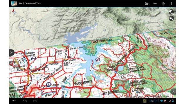
Particularly for people who move outside as cartographers, habitat mappers etc. the collection of spatial data becomes a challenge in terms of equipment as one is not eager to carry his laptop all the way around. A new android app for tablerwas developed to assist with this kind of problem facilitating the data gathering and accurate data processing. It provides display layers for professionals and also amateurs and copes with vector and raster files for recording and calculating accurate geo-information. It even offers the option of real-time tracking, which being outside can be of high interest. Summing up, the app provides all tools that are necessary to perform GIS operations on location. Still, it does not replace GIS-desktop systems, which are able to carry out large volume data processing, but supports several GIS-formats when the project is copied to a desktop system. And where does the recipe come from? From down-under where outpack is a real topic! The name of it: Mappt.
Currently supported tablets:
- Google Nexus 10
- Motorola Xoom 2
- ASUS Transformer
- ASUS Transformer Prime
- Samsung Galaxy Tab 2
- Google Nexus 7
I remember the time when I was working as a habitat mapper during summer and can imagine that this app is a big ease for recording data on location (compared to PDA).
Source: Mappt

#Business


Next article
 After couple of courses about advanced search features Google announced a self-paced, online course developed to help you better navigate the world around you by improving your use of the new Google Maps, Maps Engine Lite, and Google Earth. The project is called Mapping with Google amd will be offered from June 10 – June 24. You will be able to choose whether to explore the features of Google Maps, Google Earth, or both. In addition, you’ll have the option to complete a project, applying the skills you’ve learned to earn a certificate. You can register here: g.co/mappingcourse.
Following previous Google online courses it will be based on posted video lectures after which you will get questions to answer. There will be Google Hangouts with experts, and at the end test for users who want to receive the certificate. But don’t expect much… these are just images with our name with no signatures, stamps etc… Learn more here:
source: Google Lat Long