
The beauty of location-based technologies is in their usefulness… and who knows maybe it’s the most useful application of mapping tech ever…
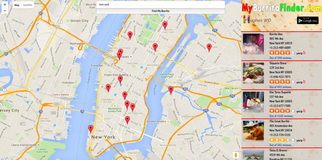
My Burrito Finder is an online tool that will help all burritos lovers find the closest place to eat their favourite food. When you enter the site it will pull your location and pin on the map all burritos places around you. On the right side of the website you’ll find info and links to Yelp. The app features all kinds of burritos places from local taquerias to national chains.
The web app is powered by Google Maps and there is an Android app version as well. Simple but awesome:).

#Business

Next article

 GPS is a great invention. It allows you to easily discover where you are and how to get from A to B. But I started to wonder… Maybe it’s a little bit too great…
Did it ever happen to you that you’ve reached your destination but you actually didn’t have a clue where you were and you wouldn’t be able to get there again without your sat nav? Within just a few years satellite navigation systems made a half of human population totally dependent from itself.
According to research human brain uses visual snapshots of new places to create a mental map of new unchartered locations. London cab drivers manage to memorize names and figure out directions to more than 25,000 streets. And so can each of us. The research shows that using GPS makes drivers detached from the environment around them. And it’s actually logical, if instead of looking round we focus on following a flashing arrow we are not creating the cognitive map of new neighbourhoods and thus we’re not likely to learn almost nothing about the way we have just driven.
But we are not lost yet… We have prepared for you a couple of tips that will allow you to save yourself from spatial orientation illiteracy. We don’t want you to stop using location-based apps because they are awesome but we want you to keep and practice your natural abilities to find our way around.
Memorize route before you leave
Instead of blindly following your sat nav on your way, check for directions and traffic before you leave. Try to memorize the route, remember characteristic points along the way, and key street names. When driving try to visualise yourself on the map. If you need check the route on your way but try to minimise it.
Follow road signs and ask for directions
In most countries road signs can be quite helpful. Note key cities along your route and follow the signs. If you are in a city don’t be afraid to ask for directions.
Use paper map
When going for a hike or walking around a new city use a paper map. It will give you a much better sense of where you are than Google Maps or any other app. Remember that getting a bit lost in a new city is also a very pleasant experience.
Practise your orientation
From time to time try to think about your orientation. What is your position in relation to the directions of the world, and in relation to river or a cost in your city. Learn how to use compass.
[td_smart_list_end]