
 Our location addiction and expectation to be able to seamlessly navigate from one place to another is something we take for granted. The behaviour of checking google maps for directions has become so common that when I ask for directions in a new city, the person (if he/she is not old) is surprised and invariably has to check the smartphone for directions.
What happens when we are denied the luxury of having a GPS/GNSS. Are other technologies capable of helping us navigate when GPS/GNSS is unable to do so? A few weeks ago, I read an interesting article on what’s next in the field of navigation? Naturally as a Geomatics engineer I was intrigued by the latest technologies that were being developed to substitute GNSS in certain applications. One of the most promising areas for new age navigation is Micro-Technology.
Most defense establishments around the globe are looking to Micro-Technology to help tide over GPS emergencies which by the way look very much possible in the near future. The DARPA (Defense Advanced Research Projects Agency) has an entire team working on such technologies: Micro-Technology for Positioning, Navigation and Timing (Micro-PNT) program. One of the primary goals of the project is to to develop technology for self-contained, chip-scale inertial navigation and precision guidance. Micro-Gryos are very popular in this regard and Northrop Grumman group has come up with a new prototype “micro-Nuclear Magnetic Resonance Gyro (micro-NMRG)” for the MICRO-PNT division of DARPA.
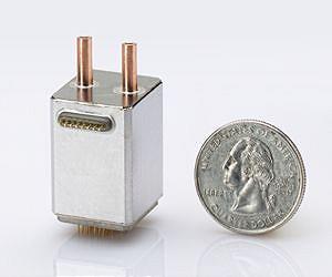 Micro-Nuclear Magnetic Resonance Gyro! Definitely sounds way too complex 😉 The concept behind this complex sounding technology device is spin of an atomic nuclei. Fundamentally, the micro-NMRG technology utilizes the use of the atomic nuclei to detect and measure rotation which in reality helps us locate ourselves and thereby navigate from A to B. The advantage of using such a Gyro in comparison to the one that is routinely being in our smartphones is that the Nuclei based gyro has no moving parts which helps avoid measuring unwanted vibration and acceleration that may be caused to the mechanical parts.
So has it solved our dependence on GPS/GNSS?
Well the answer is no! The Gyro is part of a bigger puzzle that will over a period of time help develop an alternative to GPS/GNSS but in reality the gyro is rather useless without knowing where we are i.e. initial location. GPS/GNSS still happens to be that technology that provides us information to answer the “Where” question in a global scenario.
micro-technology for navigation, positioning and timing: Promising!!


#

Next article

GOCE stands for Gravity field and steady-state Ocean Circulation Explorer and is ESA’s satellite that was developed for measuring the earth’s gravity field and ocean circulation. Since its launch in March 2009 GOCE delivered high detail information about the gravity field and its variations throughout the earth resulting in a unique model of the Geoid. The gathered data were used to create the first global high-resolution map of the boundary between Earth’s crust and mantle, called the Moho.
After almost tripling its planed life time GOCE ran out of fuel on October 21 2013 and the satellite began its descent towards atmosphere, where it will burn up. Due to its low orbit at 255km height, which is the absolute lowest orbit of any satellite and is determined by the weak signal of the gravity field, the satellite was constructed highly aerodynamically and equipped by special engines that react on any air drags from the atmosphere whose remnants at this height still exert influence. The rakish, aerodynamic design brought him the name ‘ferrari of space’.
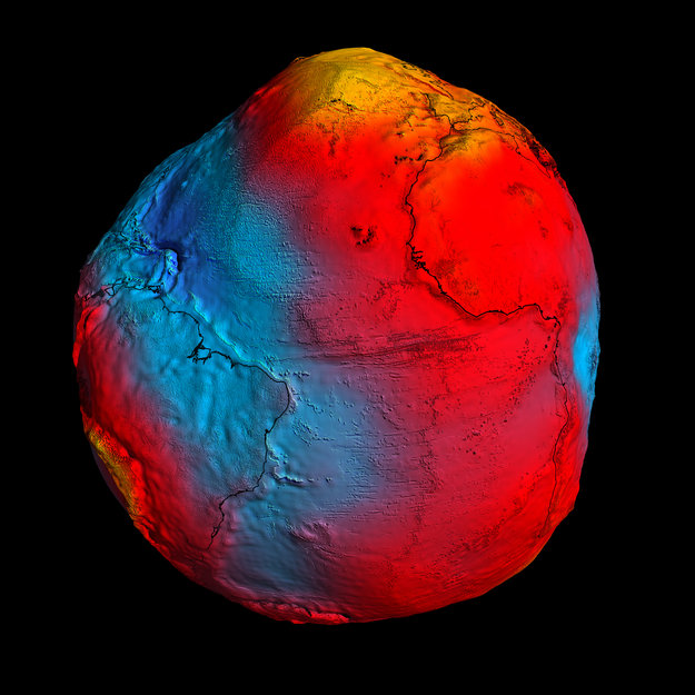
GOCE geoid
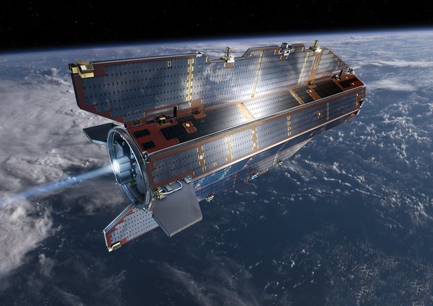
GOCE in orbit
Sea level heights and seismic activity
Aside the generation of a new, improved version of the Geoid, GOCE gave answers to geodetic questions and seismic occurrences.
Height questions
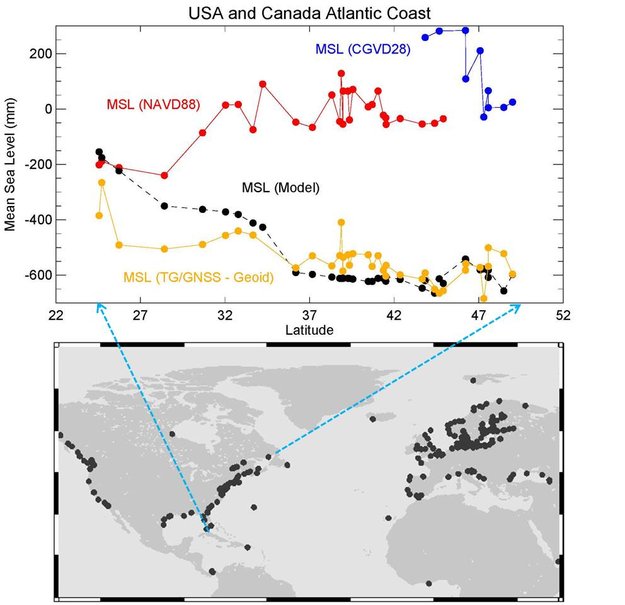
People might assume that the height of the sea is the same everywhere, but this is not true as winds, currents, tides and different temperatures cause seawater to pile up in some regions and sag in others. The traditional way of height measurement implied to compare tide gauge measurements with a ‘level’ surface and involved conventional levelling and combining measurements in the national/regional surveying datums. Until recent time, geodesists thought that the height of the sea increased with latitude along the Atlantic coast going from Florida to Canada. Their conclusions, which go back to the 1920s, were based on traditional methods that connect values of mean sea level from those tide gauge measurements. However, the new geoid of GOCE and in situ measurements were used to establish levelling heights. Combining the GOCE geoid and GPS heights at tide gauges provides indirect means of calculating sea heights by levelling along coastlines. The answer to this old question is: the sea level becomes lower going northwards along North American coastline. This has also been proofed for the North Pacific and European region. The findings are important to establish a height reference model for Canada, Mexico and US.
Sea slope
Earthquakes
GOCE also found that strong earthquakes not only produce seismic waves that spread in the earth’s interior, but also emit sound waves that can be measured in space. What happens at strong earthquakes is that the surface begins to vibrate like a drum, which produces those sound waves we know from the instrument that go from the earth’s surface to the outer space and change from centimetre to kilometre. The low frequency sound or ‘infrasound’ causes vertical movements that expand and contract the atmosphere by accelerating air particles. The highly sensitive instruments of GOCE were able to register the shock waves from the devastating earthquake in Japan on March 11, 2011. Wave-like variations in air density were also observed.
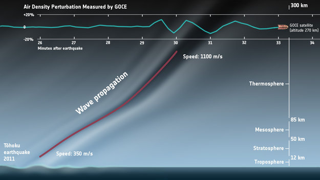
Sound wave emitted at earthquake. Scheme.