
 Thirty years ago, if you painted a picture of today’s technology to the CEO of UPS or any other company that relies on timely deliveries, they would have probably laughed. The advances made in Geo-tracking, route planning, social media, video conferencing and many other tech simplifications have been incredible. Information is sent out and received instantaneously, allowing real time business adjustments and communication for all involved.
But how can you turn this into more dollars for your P&L?
Researching the best options for your company is essential. Every business has different needs and different revenue levels. The florist on Main Street is totally different from the House of Pizza around the corner. But there are some similarities and the same technological advances can help them both increase revenues and profit.
One of the biggest technological advances has been in software integration and business applications. Data analysis is critical for any business, large or small. With the development of CRM platforms, and a wide array of human resource integration, businesses can access everything from product mix reports to employee files to marketing tools in one spot. Many require an initial investment upfront, but as your company grows with using these programs, the return becomes obvious within months.
Marketing today is at it’s pinnacle. Commercials go viral, information (good or bad) is posted on social media almost instantly from the time of it’s creation, and many companies are using social media and video hosting to reach wider audiences, promoting their goods and services. Like every advancement, there are drawbacks too. For all the good your company may do, one wrong step and the information can be accessed immediately, going viral without any way to stop it.
Remember our example of the florist and pizza shop, with different needs? These two, along with thousands of others, have one big common denominator. One of the critical pillars of the business is delivering the goods in a timely manner. The costs associated with delivery service can be exorbitant, between training, insuring, fuel, repairs, and replacement. However, there are savings that can be realized.
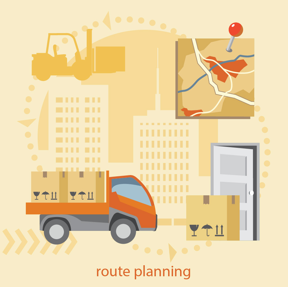
One of the best technological advances has been in Global Positioning Software. Where every company relies on delivery of goods and thousands rely on delivery of their products, global positioning advancements have been integral in growth for every industry. Route planners are part of everyday business.
Using a route planner that allows for multiple stops, time gaps and cost efficient routes will not only increase your cash flow, but it will lead to happier, less stressed drivers, dispatchers and improve customer service.
Sound too good to be true?
It is today’s reality. Multiple stop route planning is becoming ever more popular for delivery businesses as much as it is for personal uses, such as road trips. Long distance truck drivers can make excellent use of this tool for accurate arrival and departure times of their loads. To be honest, there isn’t a business that wouldn’t benefit from a multistop route planner.
By creating routes that are efficient on gas and faster by utilizing algorithms to calculate the shortest routes between the stops, money is saved from the moment you leave the lot. Between spending less on fuel and less on repairs, the savings are immediately seen. What better way to impress your boss or CFO?
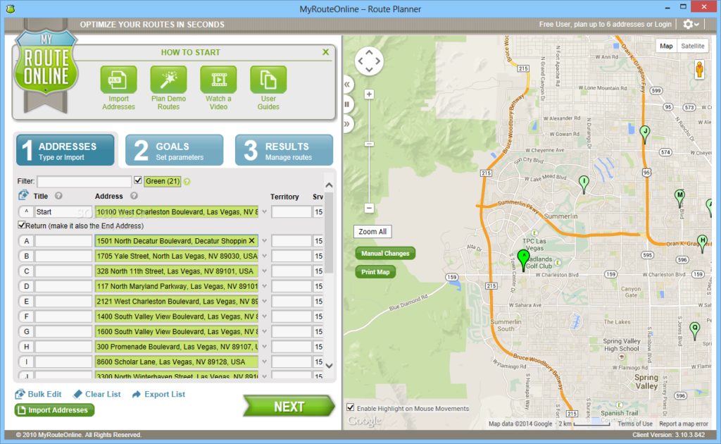
The simplicity of different programs can vary. There are some route planning tools that require special equipment to be installed in your fleet’s vehicles, to allow the drivers to import their routes and use them on the go. Others require purchasing the software and downloading it to a local computer. Some of the route planners are web-based and therefore do not require anything but internet connection, etc. Differences in cost are also visible, some tools require more support than others and therefore cost more. While you may experience savings in fuel and repairs, be cautious that you don’t spend it all on the other side for the program.
The twenty first century has already shown us tremendous progress in technology, making communication faster than it has ever been in our earthly history. What will the next 50 years hold for our world? It will be fascinating to see to what lengths technology will take us and how it will help us all do business more efficiently.


#Business


Next article
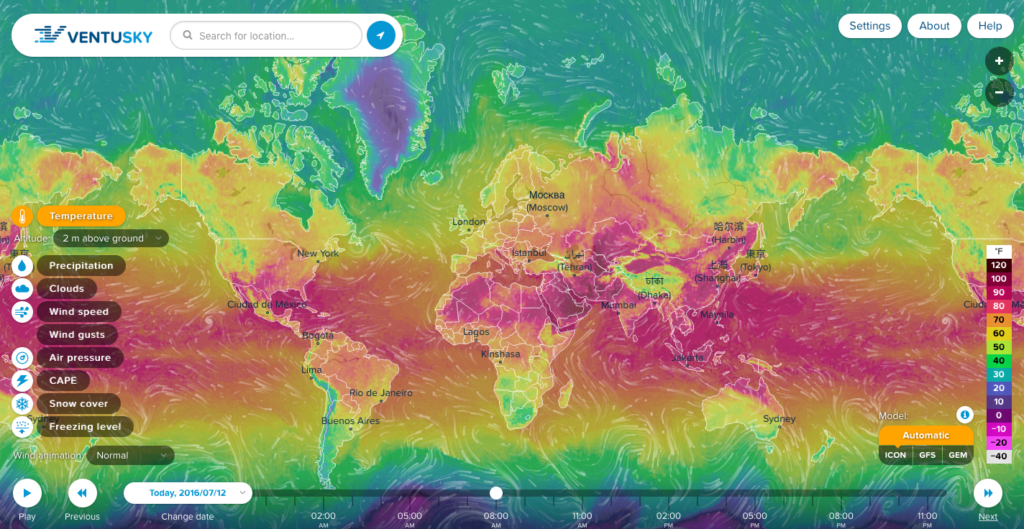
Weather maps are boring. Country level maps with cloud icons and temperature labels might be enough for most of the people but not for GeoGeeks. There is Windyty which is awesome but it’s developed primarily for skiers and surfers to know all about wind and snow forecasts.
Now there is a new project called VentuSky that takes everything awesome about streamline-based visualization and combines it with advanced weather forecasting algorithms. The service has been developed by a Czech company InMeteo specialised in weather forecasting.
The application allows users to view temperature, wind speed and direction, precipitation, air pressure, cloud and snow cover, and freezing level. You can view the forecast for 9 days ahead. Interestingly the web app allows you switch between three different meteorological forecasting models: the German National Meteorological Service institution’s Icon Model, NOAA’s Model GFS and the Canadian Meteorological Centre’s GEM Model (I guess that it’s for you to be able to choose the best weather;). We’ve reached out to InMeteo to learn a bit more about the technology behind the service:
“We have created our own map tiles, because current solutions (Google Maps, Mapbox, Bing etc.) are often expensive or slow. We don’t need so much detailed map for the weather visualisation. For the weather maps we are using a variant of a bicubic interpolation,. This is accurate, but on the other hand it is demanding on the CPU. It was difficult to keep the website smooth even on older computers.
Our website is creating from the ground in pure JS, html5 and CSS3 (backend is using PHP and C++). We are not using any third-party library for the visualisation (like Leaflet or jQuery) and it makes our solutions lightweight and fast.
We believe that this kind of visualisation is the future in the weather industry.”
What can I say… We agree that is the future of weather visualisation. Good job!