#Business #Ideas

Location-Based Services – Industry Standards

This is one those boring however necessary posts. Location-Based Services are a convergence of heterogeneous technologies, built from several separate components. In order to sustain operability, interoperability and reliability of all those systems, which highly important from user point of view the industry introduced several standards.The organizations that play significant roles in the development of LBS standards are the Open Mobile Alliance (OMA) and Open Geospatial Consortium (OGC). In addition to these, there are several other organizations that provide important components of the LBS standards infrastructure.

Open Mobile Alliance
The most important specification that OMA has come up with is MLP (Mobile Location Protocol). MLP enables LBS applications to interoperate with wireless network regardless of its interfaces (GSM, CDMA etc.) and positioning methods. MLP defines a common interface that facilitates exchange of location information between the LBS application and location servers in wireless networks. It also supports the privacy of user providing access to location information only to those who are authorized users. Hence OMA is the key enabler of mobile service specification standards that support the creation of interoperable end-to-end mobile services.
Open Geospatial Consortium
The Open Geospatial Consortium (OGC) is an international standards organization responsible for the development of standards for geospatial- and location-based services. To complement Location Interoperability Forum’s (LIF) advanced MLP services, OGC has come up with OpenLS Services that addresses the geospatial interoperability issues. Key services handled by OpenLS specification are:
  • coordinate transformation,
  • Web Mapping,
  • Geography Markup Language (GML),
  • geoprocessing and
  • Web integration.
The OpenLS platform provides open interfaces to LBS core services such as route determination, directory, location utility (geocoder that obtains x, y co-ordinates from address, and reverse geocoder that obtains address from x,y co-ordinates), presentation (display showing map, point of interest), and gateway (find position of mobile terminal ‘from the network’).
OpenLS Abstract Data Types (ADTs) are the basic information constructs used by these core services. ADTs are ‘application schemas’ of well-known data types and structures for location information encoded in OGC’s XML for Location Services (XLS). These schemas encode location information, for example, route summary and route geometry, route instructions, location, area of interest, and point of interest and address. The specifications of OpenGIS are geared toward the development of interoperable solutions that “geo-enable” the Web, wireless, and locationbased services. These specifications enable developers to make complex spatial information accessible to help deploy various services and useful applications.

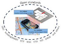
In order to make spatial standards interoperable with communication standards, such as, to integrate LBS into Internet, Web and wireless, OGC coordinates its activities with several organizations including OMA, IETF, W3C, OASIS, ISO, Parlay. Parlay is a consortium that develops open APIs based on their Open Systems Architecture (OSA) for mobile networks that provides functionality for authentication, authorization, and access to network services. APIs for OSA/Parlay enable service implementations within existing fixed and mobile telecommunications networks. This architecture/framework complements the GeoMobility Server, described here.

The GeoMobility server
The GeoMobility server provides the basic functionalities on which location-based applications are built (the OpenLS Core Services). It provides subscribers with various location-based application services and content. By using open interfaces to access network location information, this server allows applications to access a set of core services known as the OpenLS Core Services. To summarize, the GeoMobility server provides:
  • The Core Services and their OpenLS interfaces along with the OpenLS Information Model, consisting of Abstract Data Types (ADTs).
  • A set of applications build upon the Core Services and accessing them through OpenLS interfaces.
  • Content such as map data, points of interest, routes, and so on used by the Core Services; this content can also be hosted on other servers and accessed through the Internet.
  • Various supporting functions for personalization, context management, billing, and logging.
Best practices for LBS privacy
There is however lack of established user privacy standards. In 2010 CTIA Wireless Association published “CTIA’s Best Practices and Guidelines for Location Based Services” but the document is not legally valid. The guidelines emphasize user notice and consent since it is the LBS user whose privacy is at risk if location information is misused or disclosed without authorization. Per the guidelines, LBS providers must inform mobile users on how their location data will be used, disclosed and protected for each user to decide whether or not to use the LBS service or authorize disclosure. More information on the CTIA’s “Best Practices and Guidelines for Location-Based Services” is available at http://www.ctia.org/business_resources/wic/index.cfm/AID/11300.
source: Subhankar Dhar and Upkar Varshney “Challenges and Business Models for Mobile Location-based Services and Advertising” Communications of the acm, May 2011, vol. 54, no. 5, CTIA’s Best Practices and Guidelines for Location Based Services, OGC
Say thanks for this article (0)
The community is supported by:
Become a sponsor
#Business
#Business #People
Meet the founder: An interview with Chris Brown as Mapstack is awarded prestigious UK Innovation Smart Grant
Nikita Marwaha Kraetzig 11.2.2023
AWESOME 1
#Business #Featured #Ideas #Science
Harnessing the Power of 30cm Satellite Data for Construction Mega Projects
Aleks Buczkowski 07.30.2023
AWESOME 4
#Business #Featured
The Earth Observation Hub Report: 2024 Industry Trends and Analysis
Avatar for Muthukumar Kumar
Muthukumar Kumar 03.13.2024
AWESOME 2
Next article
#Business #Ideas

Location Based Services – emergency applications

One of the fundamental application of LBS is utilizing the ability to locate an individual calling to emergency response agency (911 in US, 112 in EU) who is either unaware of his/her exact location or is not able to reveal it because of an emergency situation. Based on this spatial information emergency response agency (e.g. ambulance, police, firefighters) can provide help in a quick and efficient way.
In 1996 the US Congress passed the law issued by Federal Communication Commission requiring all US mobile operators to locate emergency caller dialing number 911. In the first phase of the project required all 911 calls to be routed to the nearest public safety answering point (PSAP) and provide the PSAP with the telephone number of the originator of a wireless call and the location of the cell site or base station transmitting the call. In the second phase (2001) the wireless carriers where obliged to increase the accuracy of the geographic position of the caller up to 50-300m.
European Union Commission has passed a similar regulation –“ Commission Recommendation of 25 July 2003 on the processing of caller location information in electronic communication networks for the purpose of location-enhanced emergency call services” based on Directive 2002/22/EC . This article asks EU states to develop national regulations for mobile operators enforcing the automatic positioning of emergency calls: “Member states shall ensure that undertakings which operator public telephone networks make a caller location information available to authorities handling emergencies, to the extent technically feasible, for all calls to the single European emergency call number 112’’. The difference between approaches in US and Europe is that EU in fact did not enforce mobile operators to increase the accuracy of caller’s location. Especially in
the USA initiative brought vast development of LBS technologies and infrastructure among mobile operators that allowed them to offer other services.
Data from Location Based Services can be used as well for disaster management. One of great examples is the Ushahidi platform – an open source project which allows users to crowdsource crisis information that was sent via location-enabled mobile devices, but as well published in the Internet, local media ect. and visualize it on the map to get the ‘real picture’ of the problem and manage rescue services in the most efficient way. The platform was found to be a great help during Haiti earthquake in 2010.
Another emergency application of LBS was released in the city of Portland in 2010. The city created open source platform where citizens are able to report problems with the city infrastructure via iPhone and Android devices using dedicated application – PDX Reporter.   It enables users to select the type of issue to report, take a photo, geotag it with GPS or interactive map, add comments, and send their report to the responsible bureau. Afterwards users can view issues they have submitted and check the status of the issue.
Read on
Search