
 The Automatic Link is a new iPhone accessory that connects to the OBD (on-board diagnostic) port which is installed in every car but is usually used only by mechanics. Every car has a sort of computer (more or less advanced) that produces live data about the vehicle’s speed, fuel level, error reports etc. however drivers have a very limited access to this information. Now imagine what will happen when you integrate this data with location-aware smartphones… Do you already get the point?
How it works?
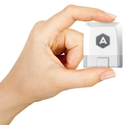
Essentially Automatic Link is a small device which you plug-in to the OBD port and it connects to your iPhone (Android coming soon) via Bluetooth 4.0. Once linked, it will launch Automatic app on the smartphone and give you access to a lot of cool data and features.
What it does?
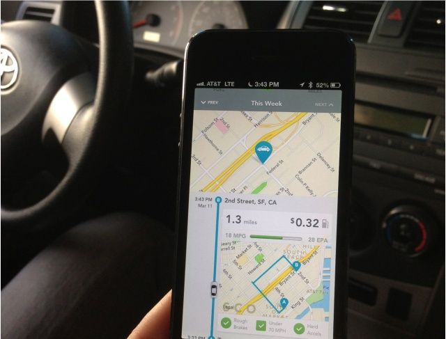
Automatic has a lot of cool features. It’ll monitor and analyse your driving habits and routes in order to help you be more fuel-efficient. It will generate a trip report for every journey with a map that shows exactly where your car went, how much gas was used, and how much did it cost you. It will give you weekly trends, compare different styles of different drivers of the same car and much more…
 Automatic will dial 911 and alert your relatives if you get in an accident. Moreover it will give you access to full diagnostic reports of your car, so that you don’t need to go to garage every time a warning indicator lights up. But there as well some other cool features like parking place reminder and so on.
Limitations and verdict
Of course there are always some limitations. First of all it will be available only in US (for now), secondly it will not support diesel cars for now. Moreover there will be no API for developers to make even cooler stuff with it. Automatic will be available for pre-orders from May for around $70 and I think it’s worth every penny. It gives you access to data about you car and your driving behaviours and adds location dimension to this equation. Can you think about anything cooler?

#Business

Next article

GALILEO – Europe’s answer to GPS and GLONASS has passed a historic milestone this week; The very first determination of a ground location using only Galileo satellites currently in orbit is now done.
This first position fix of longitude, latitude and height took place at the Navigation Laboratory at European Space Agency’s technical heart ESTEC, in Noordwijk, the Netherlands on the morning of 12 March, 2013. The position fix had an accuracy between 10 and 15 metres which is quite decent and much along expected lines taking into account the limited infrastructure and other limitations.
This milestone is a fundamental step that confirms the Galileo system is working as planned. Fixing the location of any receiver on ground requires a minimum of four satellites – in order to solve for the 4 unknowns i.e. Latitude, Longitude, Height and Time (the time is not synced between the receiver clock and satellite clock). The first two Galileo satellites were launched in October 2011, with two more added during 2012.
These four satellites were used to determine the ground location at Noordwijik, Netherlands. The location fix was the subsequent step following the testing of the satellites and the navigation messages. Navigation message send from the satellite include information regarding the satellites’ position in space expressed in Keplerian orbital parameters which are used by the receiver to calculate the distance between the satellite and it’s position which when coupled with range information from 3 more satellites helps locate the receivers’ position.
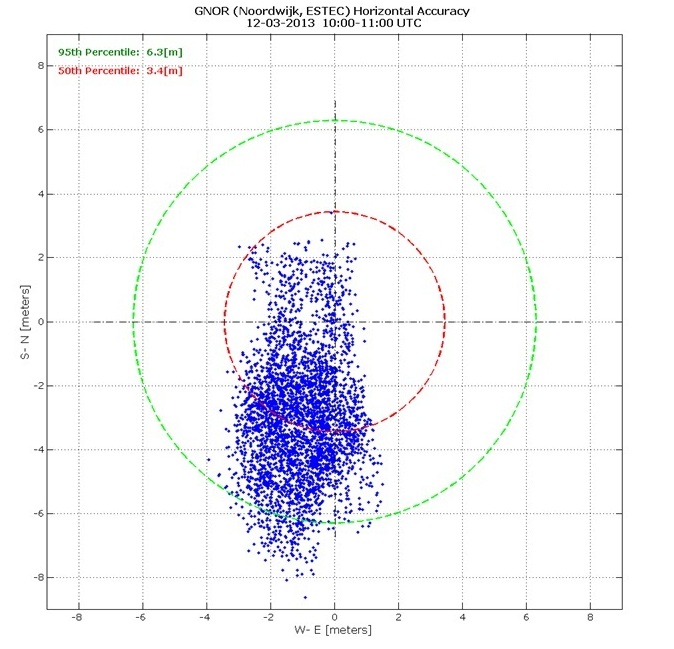
Position Fix Scatter Plot
“The test of today has a dual significance: historical and technical,” Javier Benedicto, ESA’s Galileo Project Manager.
Source: ESA