

Are you afraid that Google tracks your every move? Well… you should, the company does track your whereabouts and it doesn’t really try to hide it. In 2015, Google introduced a new feature to Maps called The Timeline, where you can view where you’ve been in the last hour, day, week, month or even a year. But The Timeline is not a new concept. All these data were previously available on a website called Google Location History which was quietly existing for a couple of years but you might have never heard about it as Google didn’t really openly advertise it.
It is really fascinating what you can do with that sort of data… But it’s also scary that one company owns that much information about almost each of us and not everyone is aware of it. Fortunately there is a way to minimize the number of location data you’re giving away. You can play around your Android and iOS devices and you should find it but it’s a bit different depending on your OS version and a device. I found out that doing it via the website is much more convenient and it offers couple of cool features.
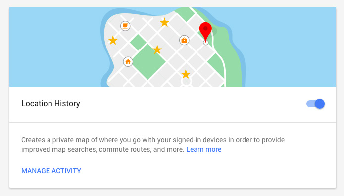
Google has a website called Activity controls where you can stop your location sharing among other services. You can pause your location sharing by simply pressing the blue button on the right.
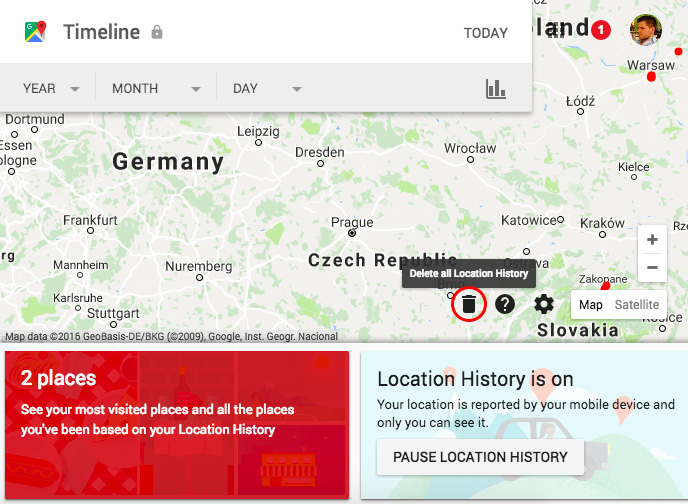
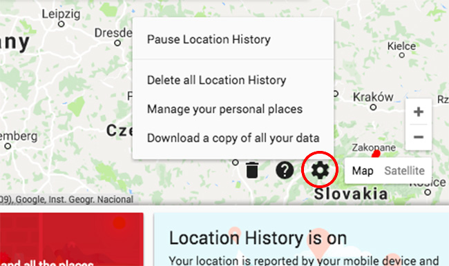
From there you can also click ‘Manage Activity’ which will bring you to Google Timeline website. On the right bottom of the website you’ll find an icon that allows you to delete your entire location history from Google services.
Interestingly if you decide to delete your personal whereabouts, Google allows you to download all your data in JSON or KML format.
When you pause or delete your Location History, Google will warn you that this might impact your mobile experience by offering you less relevant search results, ads etc. but I guess you can live with that.
The truth is that we don’t know if this will delete all your whereabouts from Google databases. If you want to be location anonymous there only one thing you can do… Stay offline.

#Featured


Next article

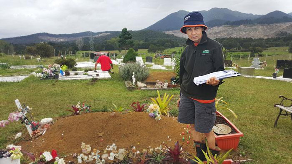
Last year during GIS Day Contest, many interesting and noble project ideas on improving communities throughout the world were sent to GIS Cloud. However, the goal set by a Maori tribe descendants (Delaraine Armstrong, Betty Cherrington and Margaret Tipene), to map burial grounds of their ancestors, was a new and unique application of GIS Cloud mapping platform, thus winning the 2nd prize in the competition.
We bring you an inspiring user story from New Zealand, about importance of personal heritage and history, a project that aims to preserve the identity of Te Orewai, Maori subtribe culture, knowledge about their history and sense of belonging.
Te Orewai, Maori subtribe, is located at the foot of the Motatau mountain.
Maori culture and heritage is shaped around deeply rooted awareness of the land and location, so burial practices play an important role in uniting their local community. That is why, says Delaraine Armstrong, they decided to map 4 tribal burial grounds with a goal to permanently digitally record each grave marker, their location and name of their ancestors:
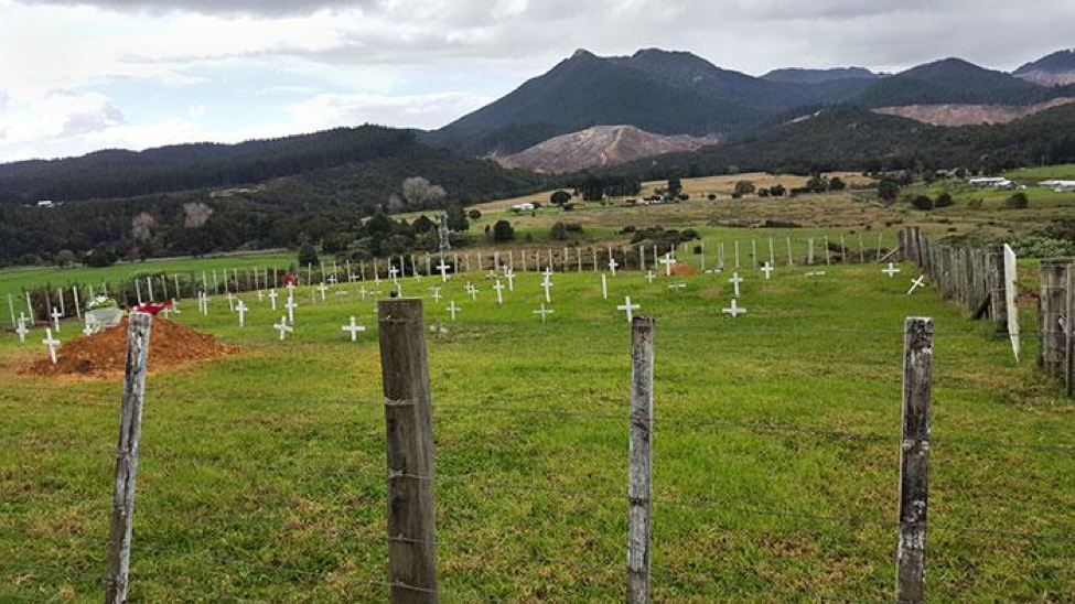
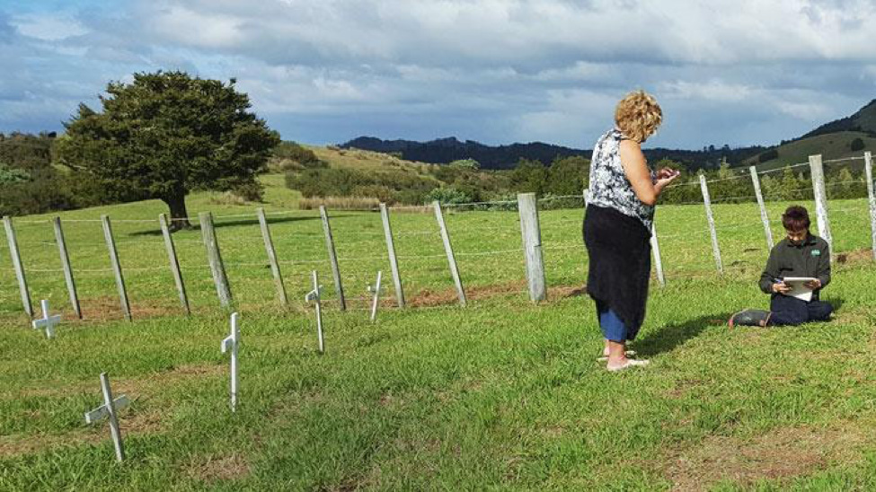
“In our Maori culture, we are very connected to the land. The mountains and rivers are personified ancestors for Maori. The picture shows the Hoterene whanau (Shortland family) cemetery of small white crosses, which has been the burial place of the Hoterene whanau for the last 150 years, and the mountain behind is our ancestral mountain, Motatau.”
There are only small white wooden crosses in this wahi tapu (burial place) because their key progenitor, Ganny Heeni, decided that everyone who was buried there will be marked with the same white wooden cross to show humility, an important value to this great dowager ancestor. For the members of Te Orewai, this meant that everyone is seen as equal. This tradition also applies to flowers that are left on the graves. Anyone who brings flowers should bring enough for all the graves in the wahi tapu. According to Delaraine, this very custom is what binds them together as one large whanau (extended family).
In the historical context, burial practices are of great cultural meaning because they include unique morning practices during 3 days after death, to acknowledge the deceased and the whanau pani – grieving family of the deceased. During these practices, Maori language is spoken, following specific cultural protocols that anchor the community to their culture and distinguish their community from others.
Seeing how burial practices and remembering the ancestors are an important identifier bearing a deep meaning in relation to different Maori subtribes, it is critical for Delaraine to preserve the names and grave markers of their ancestors. Over the years, she was in contact with many different people who wanted to find out more about their ancestors and that is one of the reasons she decided to map all the grave markers.
She and her team hope to enable those who are seeking their tupuna (ancestors) to easily locate them on an interactive map, and that in the future, other tribes and subtribes will do the same.
The Project: Mapping the Ancestral History
The Wahi Tapu data collection project began in 2015), after Delaraine, Betty and Margaret won the second prize in GIS Cloud competition.
A small team of data collectors gathered to record the names on all the graves in the wahi tapu of Te Orewai, using Mobile Data Collection. There are about 900 names recorded from the 1800’s to the present that they know of. Delaraine, Betty and Margaret think of his project as a great chance to do a community service for the community of Te Orewai.
Te Orewai have 3 main and several smaller wahi tapu locations in their valley, and the largest wahi tapu, Nga Tairua, has over 500 names recorded by data collectors. Other burial grounds are smaller, but mapping them has its own challenges. A lot of graves are left unmarked so some of the records are lost forever, and one small wahi tapu has very old graves so it is not easy to collect names and dates. Huanui is another small wahi tapu where the grave markers no longer show who is buried there, so collectors depend on those who hold the records of the graves.
In the past, there have been records for all wahi tapu, but they have gotten lost with the successive passing of people who have held those records, or because families are slowly leaving small rural settlements of the country regions and bringing these records with them. That is why it is important to digitalize this huge part of the Maori culture.
“GIS Cloud enabled us to create a project that will collate all names and grave markers of Te Orewai to the present. We wanted to provide access to an online database of names and burial grounds, to families and extended family looking for their ancestors, no matter where they live. GIS Cloud provided the software licences for our team to gather the information and set up a form to collect the data. This includes names, date of birth and death, location and the photo of the grave marker, because many of the grave markers deteriorate over time.”
Delaraine and her team have almost finished data collection and are now going through the data to ensure all details are as accurate as possible. They are in the process of creating an online database that whanau can access in the future, to know exactly where their family member or ancestor is buried, with the exact GPS location and other relevant data, such as dates and photos.
“The support from GIS Cloud has been great. Even though we have different time zones, GIS Cloud has been quick to respond to any queries, providing advice to make the process easier. None of us had experience in using GIS mapping tools, but that proved to be easy with the support of the GIS Cloud team. We are very grateful for the opportunity to create a permanent record for the future, that our whanau can access anywhere, at any time.”
Te Orewai Wahi Tapu project demonstrates an incredible application of GIS Cloud and Mobile Data Collection for the purpose of preserving an important piece of heritage for Maori in New Zealand. We hope to see more from Delaraine and her team in the next months to follow when they will release their Wahi Tapu records for the public.
In the meantime, you can show them support and find out about project’s updates by liking their project page on Facebook.