
Google first introduced price estimates for Uber back in 2014. Last year the company added a new ride services mode to Google Maps which was a big step forward but it required you to switch between apps.
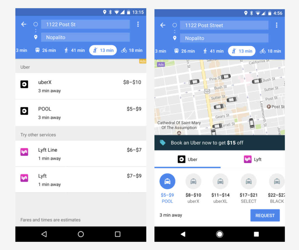
Yesterday the company announced that the latest version of Google Maps lets users request a Uber ride and pay for it directly within the app. It will also show an actual real-time location of Uber drivers around to make it a bit easier to decide whether to take a cab, use public transit, drive, walk or bike to your destination.
This is the comparison between the old version (left) and the next version of the app (right):
The update will be rolled out for both Android and iOS but in order to use it you’ll have to sign in with your Uber account info, which will pull up your stored payment info and other details.
With this update Google Maps strengthens its leading position among multimodal navigation apps that list all your possible transportation alternatives. It is interesting that the company decided to release the app in parallel on both platforms. Normally iOS users had to wait for at least a couple of weeks to get the latest features available on Android. It seems that the growing competition from HERE and Apple Maps pushed Google to change this strategy.
Interesting times!

#Business


Next article

8 Crazy Predictions for Geospatial in 2017 according to Matt Sheehan of WebMapSolutions

Let’s get crazy. None of your safe boring predictions. No going off into outer space either. Reality. At least our sense of reality. Ready? Here goes.
1. Continued hype around drones, augmented reality and anything shiny and new.
I yawn each time I see predictions talking up the new shiny geospatial toys. Sure drones will help cut the cost of data collection, and 3D and augmented reality will give us a more realistic view of our world. But the ‘shiny and cool’ out-weighs significance in terms of use-age. That hype will continue ad nauseam.
2. Mobile GIS is dead.
We’ve been surprised. Mobile GIS has been super slow to take off. We’ll put our neck’s out and say mobile GIS is dead!
All device GIS will be our 2017 reality. What do we mean here? Web apps: GIS applications which run on any platform, on any device. So take the GIS app you are using on your office PC. Run that same app on your laptop, smartphone, tablet. With GeoAppSmart for ArcGIS, we’ve gone as far as to offline enable a Web Appbuilder for ArcGIS like widget based web framework. Web GIS is truly about GIS anywhere, anytime, on any device. We’ll see an increasing emphasis on all device GIS web apps in 2017.
3. Greater demand and competition in the BI-GIS space.
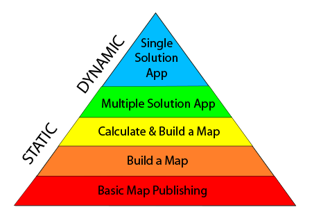
The release of Insights for ArcGIS moves Esri squarely into the BI space. Sure its not a BI product, but is designed to be used in part by BI professionals. We would have liked the first release to have been part of ArcGIS Online to maximize the potential reach of the Web app. We hope Insights is like Business Analyst: easy, simple, powerful. But that said non-traditional, particularly commercial, organizations are recognising their need to answer ‘where’ questions. In our ArcGIS Solutions Pyramid, many of the questions being asked sit in tier 3 (calculate and build map) and above.
BI professionals are now learning GIS. We believe there will be more competition in the BI-GIS space as demand increases for location analytics and location intelligence.
4. Dramatic increase in demand for GIS professionals.
Did you catch the comment in point 3 above?
“BI professionals are now learning GIS”.
That’s both a threat and an opportunity as we move into 2017. The demand for geospatial professionals will grow. But not for ‘map makers‘, for those who can think through complex business problems and apply GIS and geographic methods to provide solutions. Geo-data scientists will be an emerging group. Those of you working in the commercial sector will be particularly valuable, since you are already applying GIS to solve business problems. In 2017 we believe the value you bring to your organization will start to be better realised. From peripheral to the success of your organization, to central.
5. More focus on solving problems
There are many signs that the adoption of the newly emerging geospatial technologies has been slower than hoped or expected by the main vendors. That is the reality of new tech. Organizations cautiously move forward. With GIS we have 2 groups: existing users of GIS, and those new to the technology. For both groups we saw 2016 as a Year of Geospatial Growing Pains.
What organizations want from GIS is solutions to problems. That means an emphasis on solving. We think in 2017 sellers of GIS software will look to forge stronger relationships with service providers; partners or those aligned closely with vendors. GIS is complex, client success is more than a simple software sale. Partners are focused on solving client problems applying vendor software. Building solutions, demonstrating value. The winners of the increasingly competitive GIS technology landscape will be those with the most connected, incentivized partner communities.
6. From complex, and expensive to easy, affordable, does exactly what is needed.
This prediction really focuses on choice. There are many large, focused GIS-centric solutions in the marketplace today. As an example asset management. In the public sector, managing assets using GIS is important. There are a number of big, complex, expensive solutions on the market. Great for large organizations (with deep pockets). Not so good for medium to small. We will see in 2017 the release of light-weight solutions which are easy to install, configure and use. Competitive pricing, flexibility and extensibility will also be baked into these new releases.
7. Wider adoption of (new) Web GIS.
Let’s first define Web GIS:
Any GIS that uses web technology to communicate between a server and a client.
Web GIS is in essence a move towards fully networked GIS. Sure server based GIS was a form of Web GIS. But with the new GIS platforms being released, we now have everything connected via web technology. As an example, the desktop based ArcMap is now connected to ArcGIS Online. So you can publish your maps directly to the cloud for all to see.
As we mentioned in our 2016 A Year of Geospatial Growing Pains those familiar with GIS still need to grow their skills to take full advantage of Web GIS. They need to understand better the potential impact Web GIS will have on their organization, and find the time, or get help, implementing new Web GIS solutions. We think there will be wider adoption of Web GIS among traditional GIS sectors in 2017.
We have some concerns around those new to GIS. There has been much discussion that GIS is now quite different; publish your data, map it, drop it in a COTS (commercial off the shelf) app and you are good to go. In short that GIS has become easy. Nothing could be further from the truth. The GIS users experience should be intuitive, that is (and always has been) true. But those responsible for the GIS still require a geospatial background. See our blog post 4 ArcGIS Hits and Misses (and what we learned) for more thoughts here.
8. The emergence of a new breed of geospatial service companies.
We have found ourselves, WebMapSolutions, morphing into a quite different GIS service company. We once focused purely on software. Today we have stepped back, our emphasis is on end to end GIS services, focusing on the problem and path to a solution. The technology we push to the background. Our partner relations are changing too. Synergy, or bringing complementary skill-sets together, is key.
We see ourselves as building a GIS runway rather than solving a one off problem or providing a quick introduction (JumpStart). As the demand for GIS grows so will the importance of geospatial consultants. Just like trained business consultants, increasingly organizations will turn to trained geospatial consultants to help devise and execute their location strategy.
There you have it our crazy 2017 geospatial predictions. We are facing massive changes in our industry. As the saying goes change is good: innovation, increasing competition, new opportunities, new ways to solve problems. We are in for a fascinating year.
What are you thoughts?