
GOES-R the first of four high advanced weather satellites was launched on November 19, 2016 from Cape Canaveral, Florida. GOES –R, -S, -T and –U will extend the NOAA’s GOES geostationary satellite mission through 2036. After reaching its final orbit at around two weeks, the satellite is going to be renamed to GOES-16, continuing the series of GOES satellites in sequential numbering. GOES-R will become operational only after being calibrated and checked around one year in orbit, when it will begin observing the Western Hemisphere.
What are the highlights of the GOES-R satellite?
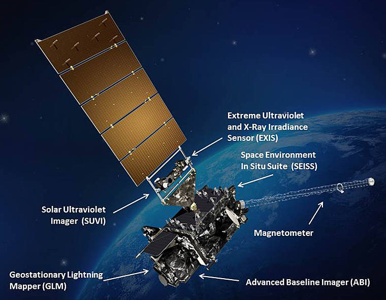
- Advanced Baseline Imager: 16 different spectral bands (compared to 5 bands on the current GOES missions) including two visible channels, four near-infrared channels, and ten infrared channels are the primary source for imaging weather, oceans and environment on Earth. – That means a three times greater spectral information, four times greater spatial resolution and five times faster temporal coverage compared to existing GOES missions. Remember that the infrared channels are particularly used to measure cloud properties.
- Extreme Ultraviolet and X-ray Irradiance Sensors: Will monitor solar irradiance in the upper atmosphere and help detecting “solar flares that could interrupt communications and reduce navigational accuracy, affecting satellites, high altitude airlines and power grids on Earth”.
- Geostationary Lightning Mapper: It is a single-channel, near-infrared optical transient sensor that can detect the momentary changes in an optical scene indicating the presence of lightning. The GLM will be the first geostationary lightning mapper and will monitor all types of lightning (in-cloud, cloud-to-cloud and cloud-to-ground) in the American region at a 10km spatial resolution.
- Magnetometer: Will provide measurements of the magnetic field that influences particle dynamics in the outer region of the magnetosphere. – Just think that the Polar Light is a visible phenomenon induced by particles that are deviated by the Earth’s magnetic field. The scope is to provide warnings to customers such as satellite operators and power utilities, for instance in case of magnetic storms.
- Space Environment In-Situ Suite: This instrument contains four sensors that measure proton, electron, and heavy ion fluxes in the magnetosphere. It will assess the risk of electrostatic discharge and radiation hazards to astronauts and satellites. The warnings may also be useful to mitigate damage to radio communication.
- Solar Ultraviolet Imager: It is a telescope that monitors the sun in the extreme ultraviolet wavelength range. The Imager will replace the GOES Solar X-ray Imager and will continue compiling full disk solar images with different spectral coverage and spatial resolution.
Why do we need such a satellite and such sensors?
Generally, the generation of GOES satellites will show an increased performance in terms of spectral and temporal coverage (around five times faster for GEOS-R) and spatial resolution (four times better). The main scope of GOES-R is to enhance the observation and consequently the prediction of local weather situations including thunderstorms, tornadoes, fog, flash floods, and other severe weather events. GOES-R will improve hurricane tracking and intensity forecasts, the prediction and warnings of severe weather, including tornadoes and thunderstorms. Improved rainfall estimates will facilitate more accurate flood warnings. Additionally GOES-R will monitor hazards such as aerosols, dust storms, volcanic eruptions, and forest fires. It is going to provide significantly more data about weather that can be used for meteorology, oceanography, climate monitoring, in-situ data collection, for search and rescue. The enhanced data provision is regarded to be very usefule for remaining resilient to climtic and weather conditions.
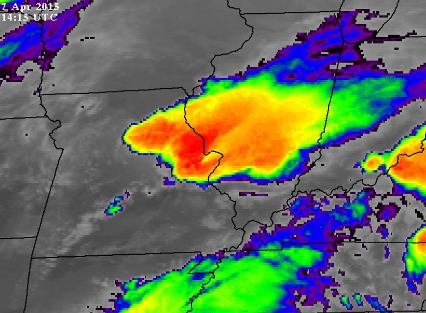
Colorized IR image from a current GOES satellite: Grey indicates warm conditions, blue points to cooler clouds and red colors show the coldest and tallest clouds most likely to produce rain. Source: Earth Science Office
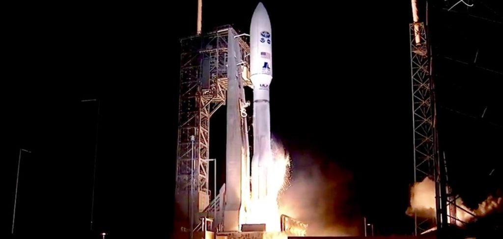
Lauch of GOES-R. Source: NOAA
GOES-R with Earth in the background. Source: NASA

#


Next article
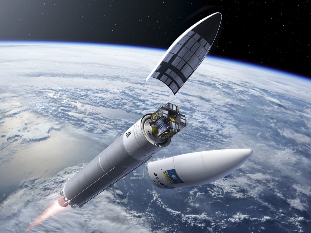

On 17 November, four Galileo satellites are scheduled for the first-ever quadruple launch atop a single Ariane 5 rocket, as a step that brings the European navigation satellite system closer to completion.
For the time being, Galileo has 14 out of 24 operational satellites in orbit. Thursday’s launch will be the eighth so far for the European navigation system and will be the largest increase of any navigation satellite constellation from a single launch, bringing the number of satellites in space to 18. By 2020, the 24-satellite Galileo constellation is expected to be complete and along with a globally distributed ground network it will provide positioning, navigation and timing (PNT) services.

Illustration du vol VA 233 Ariane 5 ES avec les Galileo
Until now, the Russian Soyuz rockets have been used to carry two satellites at a time. The quartet, though, this time will be carried into orbit through a specially modified Ariane 5 rocket using a new payload dispenser that will be able to release the satellites all at once into orbit. Although this is a great boost from European Space Agency to accelerate the constellation integration, there are various technical challenges regarding the almost simultaneous control over four independent satellites which increases the mission complexity.
The identical four 715 kg satellites are made by OHB System in Germany, while their navigation payloads are made by the British company Surrey Satellite Technology. The highly accurate timing required for precise PNT services is based on four atomic clocks that each Galileo satellite will carry: two Passive Hydrogen Maser clocks, and two Rubidium Atomic Frequency Standard (RAFS) clocks, which lead to a fourfold redundancy on each satellite in order to ensure stable operations over their whole lifetime.
Launch and Orbital Information
The launch of the four new satellites atop the Ariane 5 rocket is scheduled at 13:06 GMT (14:06 CET) on 17 November and will take place from Europe’s spaceport at Kourou, French Guiana. Although Galileo constellations’ operating orbital altitude is 23200 km, the target orbit of the quartet is actually 300 km below it, at 22900 km, allowing the four satellites to manoeuvre themselves up to the operating altitude. The reason behind this decision lies in two recent analyzed anomalies occurring in the rubidium atomic clocks aboard orbiting Galileo satellites. The ascent into this Medium Earth Orbit (MEO) will take approximately three and a half hours.
After the separation of the four satellites two by two and the placing of Ariane’s upper stage into a stable “graveyard” orbit, a combined team from ESA and CNES space agencies will take over in shifts and shepherd the Galileo satellites through their early orbits through a series of critical activities and manoeuvres. This task, however, cannot be done in a single step but rather in pairs due to its high complexity. During the manoeuvring of the first pair of satellites, there will be no activities for the second one, being in the phase known as “babysitting” and waiting for its turn.
The control of the satellites, after they get successfully onto their “drift” orbits using their onboard thrusters, will be handed over to the Galileo Control Centre in Oberpfaffenhofen, Germany, which is responsible for the satellites’ command and control for the whole of their operating lives. Except for the extensive health checks to be conducted, the tasks of the specialists include:
- Ensuring that each satellite has deployed its power-giving solar panels correctly and pointed towards the Sun, putting an end to their reliance on their onboard batteries and start using limitless solar power,
- Establishing a viable data link via a network of ground stations, and
- Switching the spacecrafts from Sun-pointing to a stable Earth-pointing mode. The satellites then will settle into their normal mode, with the navigation antenna pointing towards Earth and the solar arrays tracking the Sun.
Despite the mission’s complexity, everyone involved in the forthcoming launch has put a lot of effort in it and worked through numerous trainings and simulations to ensure that the launch will be successful and the Galileo satellites will arrive safe and sound into their nominal orbits, expected early in 2017.
If you are excited about the first-ever launch of the Galileo quartet as we are at Geoawesomeness, then you can visit the following link to watch the launch of Galileos 15-18: http://www.esa.int/Our_Activities/Navigation/Galileo/Launching_Galileo/Watch_the_launch_of_Galileos_15_18