
Please consider, if I sounds stupid. when I first heard about GIS I thought ESRI ArcGIS is GIS later on i figured out how dull I was. Then when I heard about GPS I thought it’s a wing of Geospatial Technologies. Damn me, it’s a Global Navigation Satellite System (GNSS) by USA Military, which is available for civil use for free. What if GPS is the only satellite based Position, Navigation, Time (PTN) service? what if that service is not available for civil use anymore? The answer is simple. Location Based Service – the end, Navigation – the end, no “current location” in GNSS dependent Smart phones. The consequence will be severe; We will be lost.
So, for a sustainable and reliable Location Based Services (LBS) or time stamp during bank transaction or navigation services we need non-monopolistic, cooperative, reliable and accurate GNSS Services. while surfing www, regarding these issue I have found things pretty exciting, interesting and worth to know, though all these things/happening staged behind the curtain, in policy level; maybe no direct implication but for sustainability good to know the rooted problem. So, Here the story starts. Story behind answering the question: How secure the future PNT dependent businesses are?
Global Navigation Satellite Systems (GNSS):
GNSS was all about power and control; control over satellite navigated arms, control over global instability, control over economy, control for security and safety; eventually sounds like Military and here comes the space politics. First, Satellite Navigation System named Global Positioning System (GPS) was found in 1973 by USA and became fully operational in 1995. GPS has a military origin and has been used extensively either in combat situation or in nuclear detection missions. later on, in 1987 GPS been made available for international civil use but the ultimate authority to decide GPS policy still belongs to the President, only. Besides USA, Russia is another global player in this satellite navigation market. (A satellite navigation can provide autonomous geo-spatial positioning with global coverage but requires a satellite constellation of minimum 24 satellite). Under the name GLONASS, Russia has 24 operational satellite in the GLONASS constellation science January 1996.
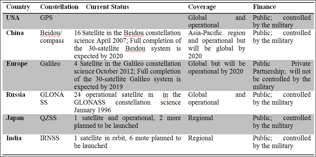
There are other two critical and crucial global players in GNSS market. Europe and China. China has 16 Satellite in the Compass (Beidou) constellation science April 2007 and Europe has 4 Satellite in the Galileo constellation science October 2012. these two constellation are regionally operational but tends to become global. Besides these four global player there are regional players as well those are India and Japan. Following table will provide the current GNSS status:
Monopoly in GNSS market:
In Global Navigation Satellite Systems (GNSS), so far the GPS US is widely used worldwide for civilian application and possesses a majority share of global satellite navigation market. but there are few things to put light on. In GPS US, an artificial error called Selective Availability (SA) was integrated into civilian-use signal to deteriorate its accuracy for fear of potential antagonistic use (…though it’s not active anymore but opportunity to activate such option is still in place). Then again, the so-called GPS M-Band facilitates the option to prevent all GPS transmissions except the military signals or the particular signal of interests. Such independent installations not only undermined the interests of worldwide civilian GPS users, but also diminished US reliability of satellite navigation data provision.
EGNOS/Galileo arrival dissolves GNSS Monopoly:
The Galileo Satellite Navigation, European GNSS, was the product of European Dissatisfaction of GPS US data accuracy & services and European overdependence on US technologies. These issues lead European towards the idea of Galileo Constellation; developing its own system, independent from US GPS, as an insurance against the possible US denial of access to GPS and also for an independent European common foreign and security policy and to survive the future security threat and economic competition. Europe needed a system under its own control on a permanent basis and nobody can shut it down.
The US Strongly opposed the Galileo program due to its impact on US Security and economic interests. the Gelileo system would interfere with the GPS signals, particularly military one. As a result, the USA was worried that the signal interference caused by Galileo system might endanger US military operations, moreover its beyond their control, would weaken its leadership in the NATO alliance. On the other hand, regarding economic interest, Galileo would generate global standard (Position, Navigation, Timing ) PNT data and that as a threat to USA’s economic interest because that would break the US monopoly on Commercial Satellite Navigation Applications (CSNA). So USA asked Europe to continue depending on GPS but no guarantee on quality data provision. USA also mentioned upgraded GPS would make Galileo unnecessary. Nevertheless European found developing own GNSS would be more cost-effective so partial Galileo constellation is in orbit.
There is one more thing to mention about Europe-Chine cooperation and then tear down regarding Galileo Program. The EU and China signed the “Sino-European Galileo Plan Technology Cooperation Agreement” in 2003. This cooperation took place because of European Public funding insufficiency and the private sector was not ready to invest without tangible outcome. On the other hand, European-Chinese technology exchange was considered a betrayal by the US, when the US adopted a technology containment strategy toward China but the EU was happy to allow China to buy a 20% share of Galileo because this exchange would enable European arms manufacturers to sell China the weapons and equipment confined only through Galileo control. China had plans to build a military navigation network but it soon grew clear that China intended Beidou to compete with Galileo. The Europeans also came to realize that China was determined to extract as much dual-use technology as possible for its home-grown satellites. Brussels also grew frustrated at China’s plan to use frequencies for Beidou’s military service that could overlap with Galileo’s restricted signal for European government and military use. By 2010, Galileo had become a 100-percent taxpayer financed project and came under new rules governing security, technology and procurement. And the partnership with China was effectively dissolved.
Compatibility and Interoperability among GNSS:
Compatibility and Interoperability between GNSS, GPS and GLONASS was ensured long ago but with the arrival of Galileo the same question raised again. what about compatibility between GPS and Galileo? GPS and Galileo have different interest so there were in competition and before 2000 none of them considered the possibility of cooperation but that lead to THE common problem. The user started asking, should they carry two different device for GPS and Galileo? to answer that question and make it economically sustainable compatibility and interoperability between GPS and Galileo was necessary. later on, after series of discussion compatibility and interoperability between GPS and Galileo was ensured in 2004, particularly their strategies seems shifted from competition to cooperation. Still there is one more GNSS left. what about Compass (Beidou)?
Finally, at system level, interoperability can be viewed as the capability of all systems to provide the same solution standalone (with the respective performance constraints). In other words, a GPS, GLONASS or Galileo receiver should be able to provide the same navigation solution – within the respective system accuracy – when used standalone. In this scope, GPS and Galileo can be said to be interoperable at system level, while bringing the advantage of being independently operated thus providing redundancy to the GNSS user community – hence increasing the market confidence on the technology.
Current GNSS cooperation, PTN and future:
Quality Position Navigation and Time data helps to anything to everything. For an instance GNSS based ultra accurate timing provide a low cost time references that increased the reliability of banking transactions, share transactions or simple everyday transaction.
Name any sector, you will find positioning or navigation services in that arena. importantly applications for individual handsets and mobile phones (LBS), road transport, aviation, maritime transport, precision agriculture and environment protection, civil protection and surveillance etc are the major stakeholder of GNSS and LBS. following videos will provide a better and detailed picture of LBS scopes and GNSS, Gelileo and Economic thinking:
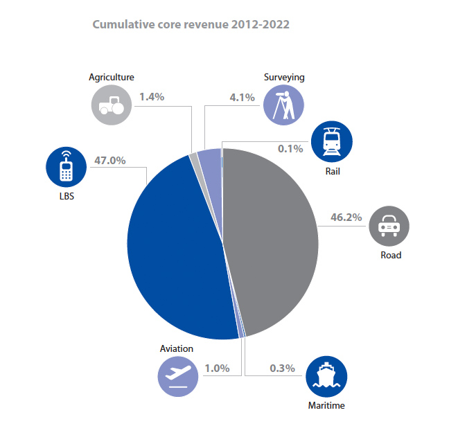
The Global Navigation Satellite System (GNSS) market comprises products (receivers and devices) and services using GNSS-based positioning as a significant enabler. Growing number of GNSS devices (i.e., GNSS-enabled smart phones, Personal Navigation Devices, Aviations, Precision agriculture system etc.) and diversified market segments (i.e., Location-Based Services (LBS), Road, Aviation, Rail, Maritime, Agriculture, Surveying etc.) making the GNSS market border, competitive and interesting.
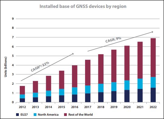
Installed base of GNSS devices by region
According to GNSS Market Report issue 3, 2013, there will be Seven billion GNSS devices by 2022 – almost one for every person on the planet will increase almost four-fold, largely driven by increased penetration in regions outside Europe and North America and this A growing GNSS market offers opportunities long term GNSS based business opportunities and if we analyze the market share we can see that Smartphones dominate global GNSS revenues and are expanding into other market segments.
A growing GNSS market offers opportunities in a complex technological landscape
All these factors indicates one thing: the future is GNSS based business but this sort of technology dependent business requires GNSS technology availability with higher level of accuracy, predictability and reliability and GNSS monopoly is never good for these business’s health. Arrival of Galileo filled the gap and making position, navigation and time stamp based business more secured and sustainable.
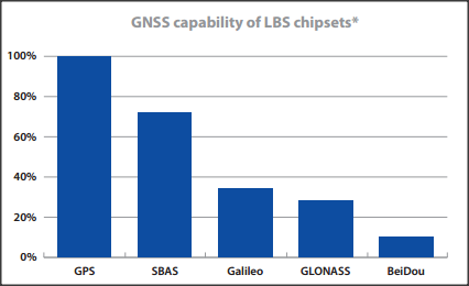
Now Multi-constellation receivers become widely available on the market and the number but the following bar graph required to be changed to bring more stable and flexible market. what we need is all device with 100% capability of any kind of GNSS capability. I think here is a super chance for the European GPS producer/seller to take over future global GPS device market and future global PNT dependent market.
Conclusion:
The GNSS power, shift from compaction to corporation attitude can bring greater good. cooperation can attain all the technical issues like accuracy, innovative services, availability, precision. for an instance, In a combined GPS-Galileo use (compared to GPS alone) the higher number of satellites available to the user will offer higher precision.(up to within a few centimeters).Besides, The greater number of satellites will also improve the availability of the signals in high-rise cities, where buildings can obstruct signals from satellites that are low on the horizon (reducing the so-called ‘urban-canyon’ effect).
Here, in this article, we mostly talked about Galileo because that’s the future because of its sophisticated, precise, sustainable and advanced technology; the best GNSS in the market better than US GPS. what about GLONASS? this program is not stable because of their internal economic status. for an instance about accuracy they are not relatively unsatisfactory (see the following figure) but when its stable and operational it will improve the GNSS market predictability and stability as well.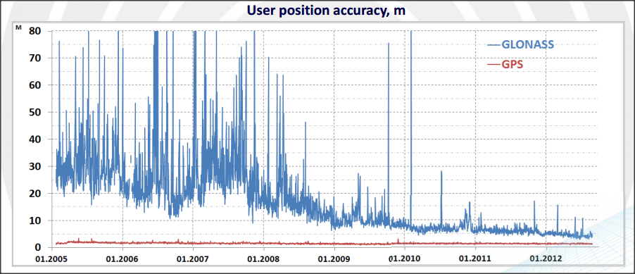
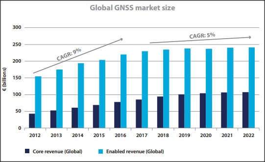
According to GNSS Market Report issue 3, 2013, The market for PNT applications will reach €240bn by the end of the decade, with about 7 % of gross domestic product – equal to €800bn in Europe and global annual market for PNT products and services is currently valued at 124 billion Euros and is expected to grow over the next decade, leading to an estimated market size of €244 billion in 2020. These statistics completely make sense. so, we have to try keep balancing GNSS, space politics and PNT product and services to attain the drastic future market goal.
GNSS has many things to do beyond Economic Development and Earning Revenue directly. there are intangible profit or indirect profit. GNSS for saving lives in disaster situation, GNSS for food security, GNSS for peace and conflict. this sort of services are difficult to measure in monetary scale and we all will accept that it’s a great deal and ensure sustainable socio-economic development of the world. so the urge indeed in need of GNSS cooperation among global player.
How secure future PNT dependent businesses are? — secure, reliable and sustainable.


#


Next article

The simple answer after GSLV-D5* launch on January 5th is YES! Only five countries in the world – US, Russia, France, Japan and China has done this before ! So, lets talk about what exactly the Indian Space Research Organization’s milestone this time is !
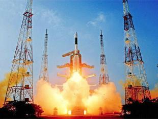
“”Indigenous cryogenic engine” might sound like a Latin phrase to most of us. In space research, it marks a defining moment as that shows the ability of a country to put satellites weighing over two tonnes in orbit! Using cryogenic liquid propellants like liquid oxygen at -183 deg Celsius and liquid nitrogen at -253 deg Celsius enable a rocket to get the satellite of that dimension into orbit within few minutes. GSLV- D5 successfully placed the 1982 kg GSAT communication satellite into orbit, just 17 minutes after the launch.
This signifies two decades of hard work for the Indian Space community! After being denied the technology transfer from other countries under pressure from the US, followed by a terrible failure back in 2010, ISRO has once again reached an extraordinary milestone! In this country, though the least appreciated, space research has played a commendable role, not only in development but also in improving the everyday life of a common citizen!
*GSLV – Geosynchronous Satellite Launch Vehicle