Meet Gather – the social startup that is using geospatial data and data science to get toilets to people who need them #TheNextGeo

Over 2 billion people across the world use Facebook every day and close to 4.2 billion people have access to the internet (source). With numbers like this, it is easy to imagine the world as a perfect place for everyone. Alas, it isn’t. Yet, there is hope. This week on #TheNextGeo, it’s an absolute pleasure to chat with Lindsey Noakes, the founder of Gather Hub, a London-based social startup to learn more about the urban sanitation crisis that the world is facing and how they are trying to get toilets to people who need them using geospatial data and data science. Read on!
Gather brings people and data together to solve the urban sanitation crisis. By 2030, three billion people will be living in cities around the world without access to a proper toilet. We’re using geospatial data and data science to get toilets to people who need them.
-
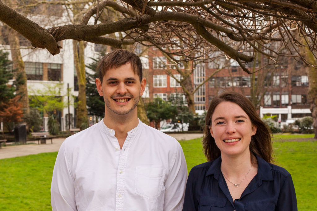
- Meet the team behind Gather Hub

-

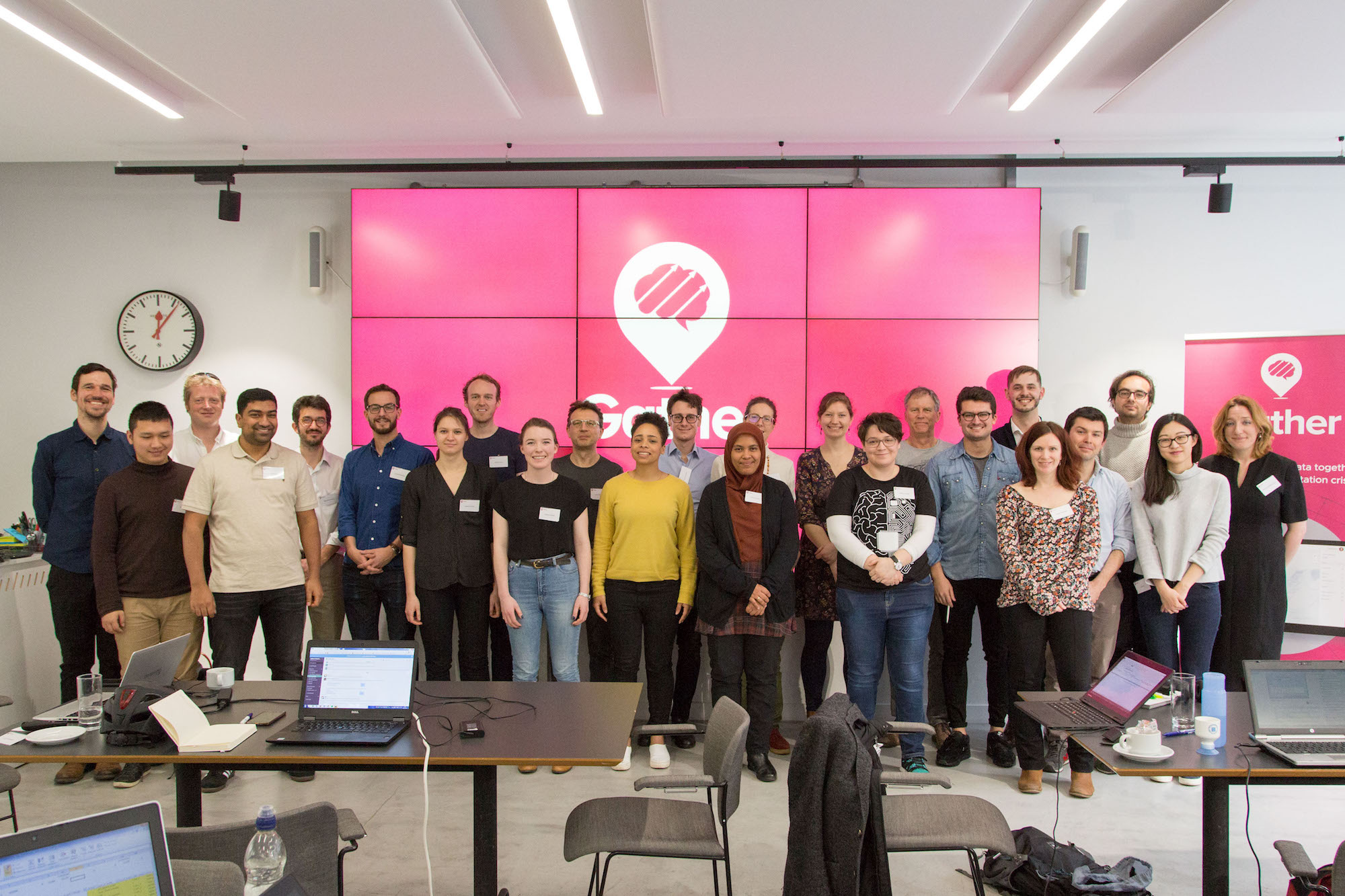
- The extended team
Q: It’s common to hear many people say that they want to work for a company that is changing the world for better. You guys at Gather hub are actually doing it! When did you decide that you wanted to start Gather? What was your motivation to get into urban sanitation?
A: John was doing some research into under-funded global issues, and was seconded to a sanitation charity working in India. I was a trustee for that same sanitation charity. We met in November 2015, and a week later we both decided to quite our jobs and launch Gather! While we’re very different people, we share values of accountability, collaboration and maximising impact.
We launched Gather because we were inspired by the potential of sanitation. Good sanitation underpins so many crucial areas of human development: child mortality, dignity, education, environment, health and productivity. Without proper toilets, nothing else really works.
Q: If I understood correctly, it is estimated that more than 3 billion people will be living without an access to a toilet by 2030 across the world! That’s just shocking. 3 billion people! How do we make sure that this isn’t the reality in 2030! What is the biggest challenge when it comes to urban sanitation?
A: That’s right, three billion people. And since I was born in 1990, the world has made absolutely no progress: the proportion of people living without a toilet has stayed the same for 28 years. Recently there has been significant investment in the development of new toilet technologies: fantastic inventions and innovations designed to meet the needs of underserved communities, reduce water usage and reclaim valuable nutrients from human waste. But despite this, we have only been able to keep pace with population growth. Clearly, something needs to change. We believe this requires a radical new approach – a systemic change in the way sanitation is provided in cities.
Sanitation is a complex sector, and we know there is no silver bullet for the urban sanitation crisis. We are focusing on one very specific area: urban sanitation data. We’re focusing on data because of our research, which includes interviews with nearly 100 people working across the sanitation sector and reports from the World Bank and academic experts. From our research, we’ve identified that the lack of quality data on sanitation is making the sanitation sector less efficient, effective and collaborative than it should be. Sanitation funders can’t direct their investments effectively, and sanitation providers can’t identify where their new designs are needed most. And people in the most vulnerable communities are left without sanitation as a result. Sanitation organisations are increasingly collecting large quantities of data but no organisation has so far had the skills, vision and freedom to turn this resource into something transformative for the whole sanitation sector. That’s where we come in.
Q: Urban sanitation and public health are the responsibility of a government, which means more often than not, you are working with a bureaucratic system. What is your approach to convince a local government to work with you?
A: We always work through local partners, who have extremely good and close relationships with local governments. We support our partners in their data discussions with local government, giving them the tools they need to understand how they can collect, manage and use their data better and cheaper. We want to support the amazing work that governments, social enterprises and charities are doing by helping them to use data better.
Q: In March earlier this year, you launched what you call “the world’s first urban sanitation data dive”, tell us more about it? What was the objective behind the data dive?
A: Our data dive was one of the highlights of our time running Gather. Twenty-one data scientists from across the UK volunteered two days of their time; half of attendees were women and half were from minority backgrounds, so we had a really exciting mix of perspectives, skills and ideas. We were looking at data from Lusaka in Zambia, in one of the largest and most comprehensive sanitation data sets ever collected. It was a very exploratory event; the data scientists looked at a range of questions, from assessing the quality of the data to whether it was possible to optimise the routes taken by toilet emptying service providers. One of the best things about the data dive was that it produced so many new questions for us, so we have so much to explore at future data dives! I love that we were able to give people an environment to apply their skills to a completely new sector, and have the freedom to investigate whatever most interested them in the data. My favourite bit of feedback came from one of the attendees who said “it’s rare to be made to feel so valued for our skills, be told it’s OK to make mistakes, and to be constantly celebrated for our creativity”.
Q: It’s easy to see location data and geospatial analysis play an important role at Gather. Considering that both of the founders aren’t from a Geomatics/GIS background, was what a problem?
A: It has been a challenge, definitely! We’ve tackled it in two ways, which seems to epitomise how we tackle most problems we come up against at Gather. The first is by upskilling: John and I are constantly teaching ourselves the basics of different programmes or doing a crash course in a particular area of toilet engineering. I used R and ArcGIS during my undergraduate degree, so I dusted off my notes and refreshed my memory.
This definitely only gets us so far though: for the most part we rely on our incredible volunteers, and our panel of expert advisors. But even with their support, we are extremely keen to bring on our very own data scientist as soon as our budget allows!
Q: Could you maybe tell us a bit more about how you use location data and geospatial analysis at Gather?
A: We use location data to understand where toilets are, and where there are people who need toilets. So location data and geospatial analysis underpin everything we do at Gather.
Q: You did already make it to the Forbes 30 under 30 lists! Congratulations on that! Where do you see yourself and Gather in 3 years from now?
A: Thank you! It’s amazing to be listed among such an incredible group of young people; we don’t feel like we’ve done nearly enough to qualify but it’s a great accolade to have!
In three years, we want to be embedded in sanitation provision in eight emerging cities around the world, home to 26 million people. We want data to be driving decision making in sanitation organisations around the world, and for these organisations to understand the power of the data they are collecting.
Q: As a startup founder, I am sure that there are many things that you must have learnt along the way. What was the most useful advice that you received so far?
A: “Find your niche by playing to your strengths.” That’s an amalgamation of advice we’ve received from our trustees and Ed Parsons from Google, who sits on our advisory board. But it’s still the most useful! It helps us work out which opportunities we should grab, and which we need to say no to because they might take us on a path which doesn’t help us achieve our mission. We are surrounded by so many incredible, enthusiastic people who want to help us succeed, but as founders John and I have to hold our mission and ensure everything we do feeds into it. Also, playing to our strengths helps us to enjoy our jobs and do them better!
Q: Gather is a social enterprise. That being said, you still have to raise money to hire people and expand your goodwill. How do you do that today? Do local governments hire you for your services or do you work via donations?
A: We are funded entirely through donations, and we’re so grateful for the trust and belief that our donors have put in us. Since 2016, 15 people have committed to covering our core costs through annual donations for a minimum of three years. We also crowdfunded a data collection exercise in 2017, where 34 people helped us to fund a project to train nine local young people to map household sanitation for 90,000 people in Nairobi, Kenya.
We benefit hugely from gifts in kind: everything from office space from Geovation; to legal advice; to SalesForce donating our laptops. In fact, for every £1 we receive in donations, our supporters match it with an additional £1.37 worth of pro bono support.
Q: If anyone would like to reach you, what would be the best way to do so? How can we help you in your mission?
A: Everything we do is through partnership at Gather. Collaboration is one of our key values, and we don’t do anything alone. This year alone we’ve utilised the skills of 35 volunteers, so if anyone is interested in helping out please get in touch!
We love to chat! Drop us an email at hello@gatherhub.org or follow us on Twitter @gatherhub_.
Q: Okay, this is a tricky one – on a scale of 1 to 10 (10 being the highest), how geoawesome do you feel today?
A: It’s our first day in our beautiful new office with Geovation, this morning we had an amazing partnership offer from an incredible company, and it’s my birthday tomorrow! Today is a solid Geoawesome 10.
Q: Any closing remarks for anyone looking to start their own social startup?
A: Do it. Work out where your skills lie and use them. Grow your networks and get mentors wherever you can: you don’t have to be an expert in everything but you do have to surround yourself with experts who can help you figure out the answers you don’t have. Even if you don’t want to start a new organisation, work out how you can drive change where you are.
The Next Geo is supported by Geovation:
 Location is everywhere, and our mission is to expand its use in the UK’s innovation community. So we’re here to help you along your journey to success. Get on board and let’s start with your idea…
Learn more about Geovation and how they can help turn your idea into reality at geovation.uk
About The Next Geo
The Next Geo is all about discovering the people and companies that are changing the geospatial industry – unearthing their stories, discovering their products, understanding their business models and celebrating their success! You can read more about the series and the vision behind it here.
We know it takes a village, and so we are thrilled to have your feedback, suggestions, and any leads you think should be featured on The Next Geo! Share with us, and we’ll share it with the world! You can reach us at info@geoawesomeness.com or via social media 🙂


#Business


Next article

The British royal family has long been a source of fascination for the entire world. No other monarchy of any other nation sparkes the same level of excitement. This set of maps and charts will help you understand the phenomenon of the British royal family.
1. Royal Family tree and line of succession
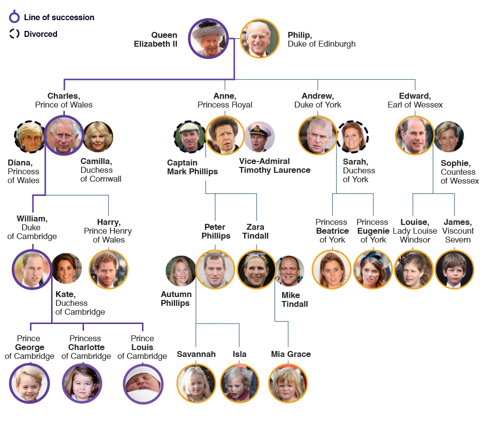
source: BBC
2. The popularity of British Monarchy
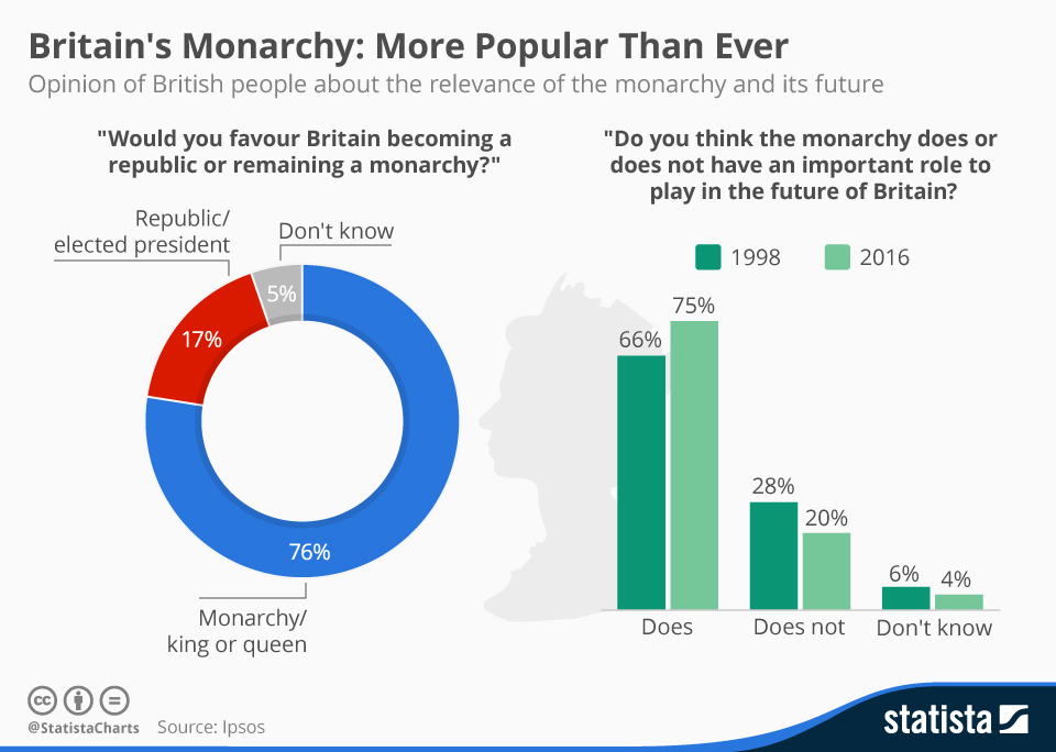
source: Statista
3. Does the monarchy benefit the UK’s economy?
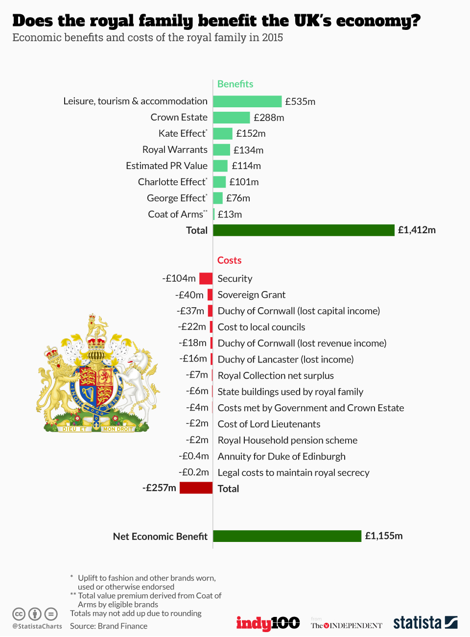
source: Statista
4. The Queen and the Commonwealth
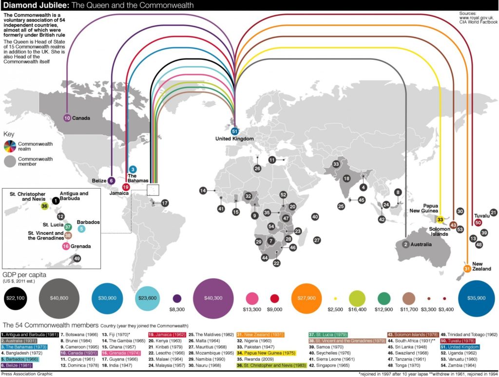
source: Visual.ly
5. Map of The British Commonwealth Of Nations
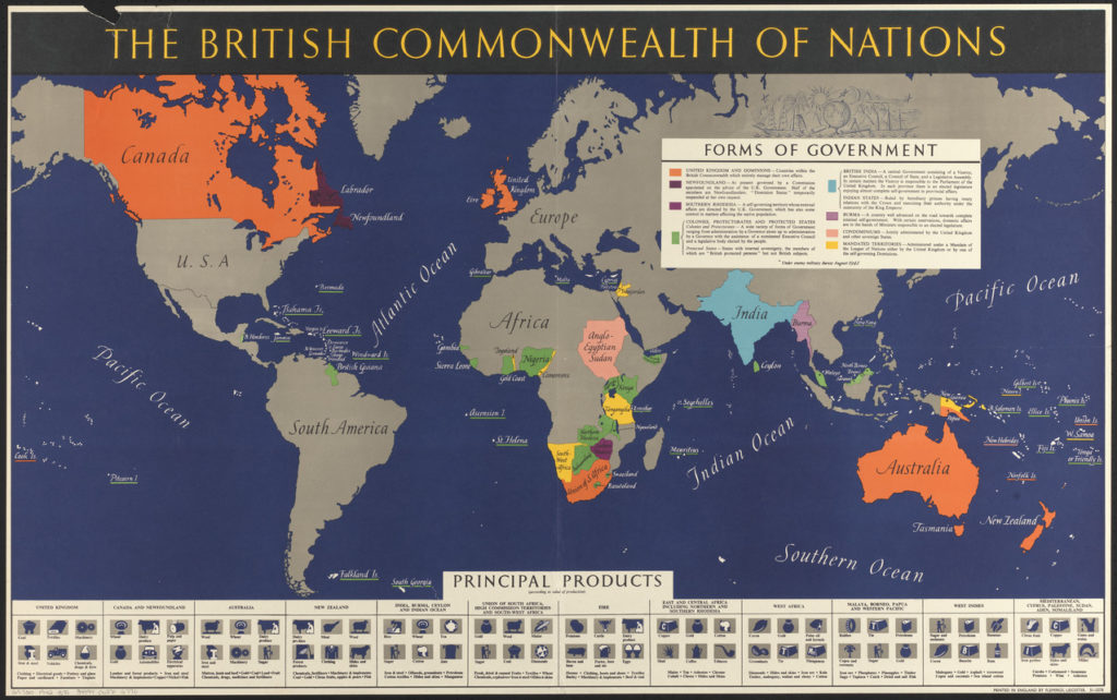
Update: Please note that the map is dated from 1942 when Ireland was still in the Commonwealth.
source: Digital Commonwealth
6. Map of Royal Residencies
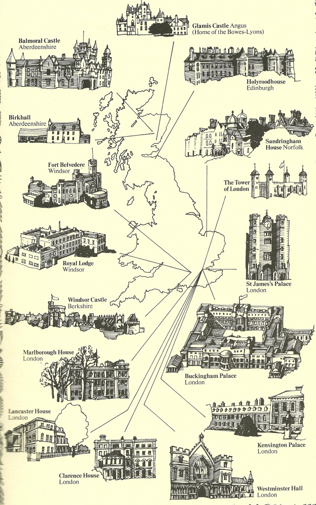
source: Tes
7. The world’s 26 remaining monarchies
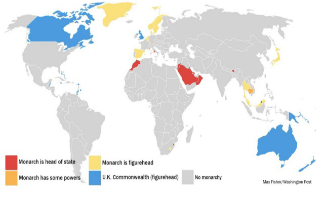
source: Washington Post
8. Royal wedding vs average wedding
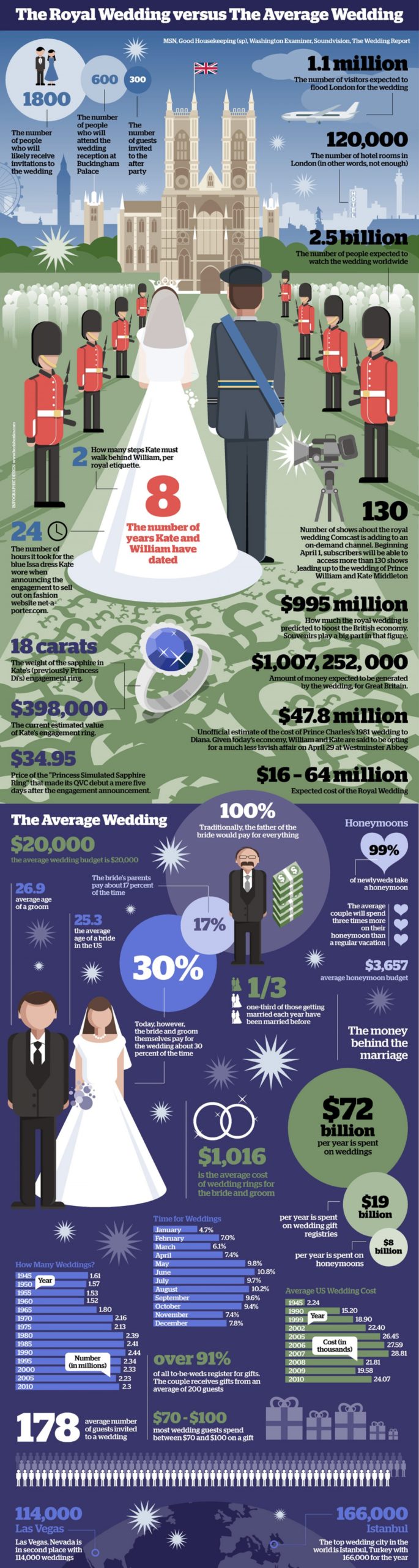
source: Visual.ly
9. 2011 Royal Wedding social media reach
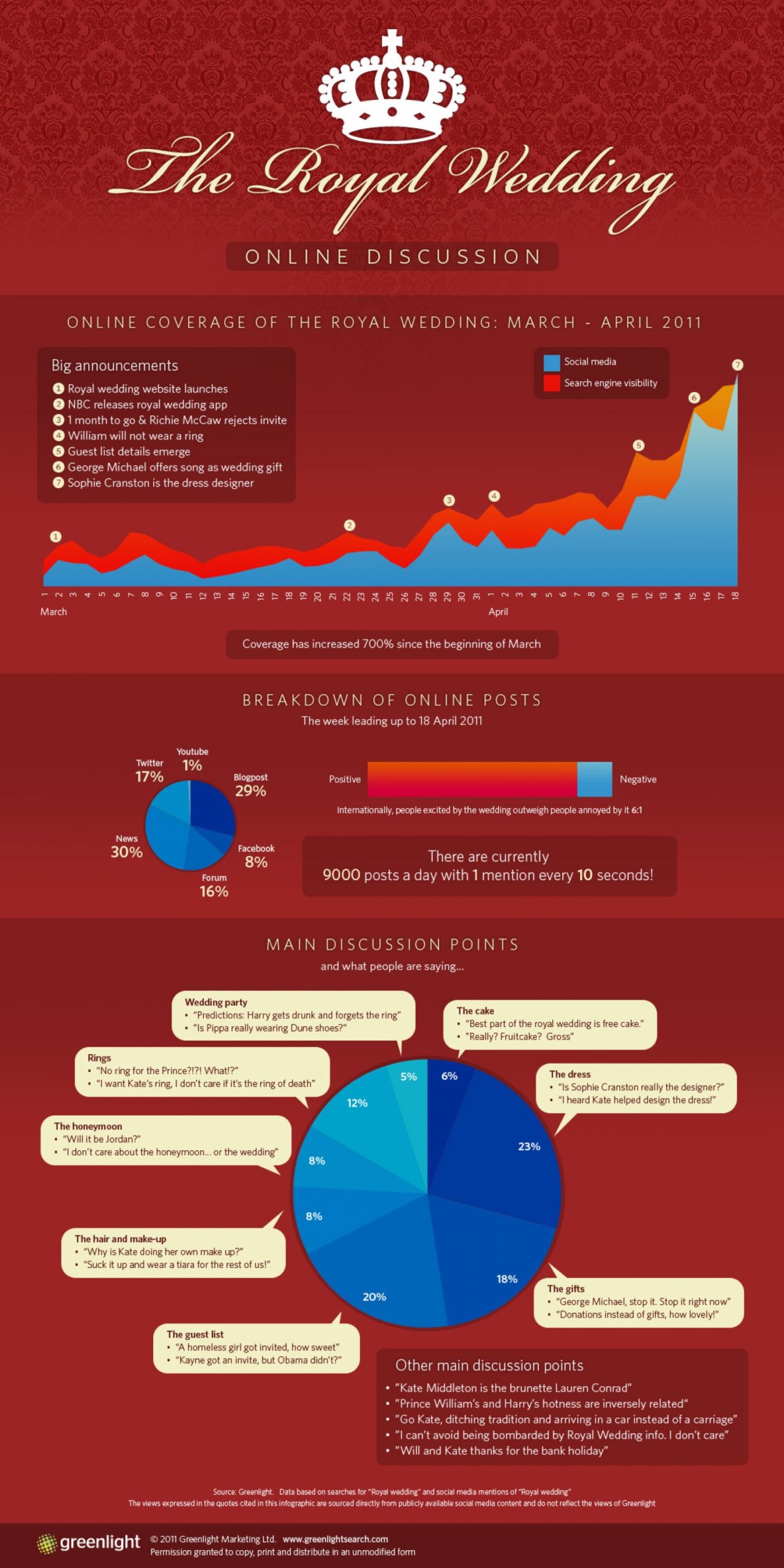
source: Visual.ly
10. British royal babies at birth
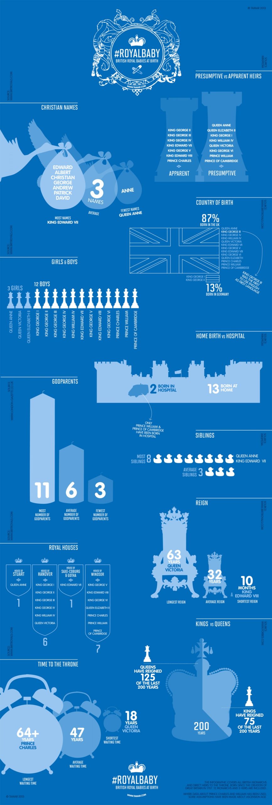
source: Visual.ly