
2018 was an exciting year for the geospatial industry; Google Maps API pulling the rug from under developers’ feet notwithstanding. The power of crowdsourced location data came to fore when Snap Map became the unofficial source of on-ground reporting during the Marjory Stoneman Douglas High School shooting in the US. Artificial intelligence programs extracted road networks from aerial imagery (with astonishing success rates) and helped local taxi operators to outshine the Ubers of the world. Google and Mapbox focused on location-based gamification, while HERE chased indoor mapping by acquiring Micello and partnering with Jibestream.
Recalling some of the many developments from geospatial industry in 2018 made us wonder: What should we expect this year? We turned to the insiders for answers!
Augmented reality will come of age
Martin Strigač, CEO, Sygic
“Augmented reality is not a fresh topic, but until recently, tech companies haven’t been capable of utilizing this technology and bringing it to wider masses. In past months we have observed solutions ranging from assisted reality glasses used for repair and maintenance to augmented reality apps for schools. Complex solutions for car and motorbike drivers will follow soon. The potential of connecting the real world with digital is in our industry almost inexhaustible. Imagine the real-life situation, when your navigation will identify dangerous situation on the road and will help you to decide what action to take.”
Making sensors and systems geo-aware
Campbell Kennedy, CEO, LocusLabs
“I am most excited about the incorporation of real-time and transient data into geospatial applications. So much of IoT and smart building applications involve spatial awareness and queryability, but historically, many of the sensors and systems are isolated and not geo-aware. In reality, our world is constantly changing, especially as we start representing smaller and smaller objects like cars, people, furniture, etc. Powerful geospatial frameworks designed for representing and managing data for these applications will unlock new realms of analysis and intelligence.”
Better counter-drone technology and UTM
Brooke Tapsall, Founder and CEO, DroneALERT
“Counter-UAV, geofencing, and unmanned traffic management (UTM) are the developments I’m most keenly watching in the drone industry this year. The use of location data for counter-UAV is still growing as an idea to be fully embraced with confidence by the authorities. Its complimentary avenues are also not being fully explored as of now. In the wake of the recent UK airports drone incidents at Gatwick and Heathrow, I feel if the technology were in place, the use of location data could have aided the investigations. Further, though geofencing and UTM technologies have been incorporated into some drones now, they are still in a developing stage – albeit with great potential and necessity for future drone flights and drone management in the skies.”
The year of ‘live’ location data
Jimmy Perron, CEO, NSim Technologies
“In our view, in 2019, we will see more and more business trying to leverage their ‘live’ location data. The combination of geospatial data (GIS) and live IoT data will drive the adoption of real-time business processes in multiple industries. The IoTs field focuses mainly on objects that are connected to the cloud space by focusing on how and what. However, by adding a where to the equation, we open ourselves up to a world of new opportunities by enabling ‘location intelligence’. With more than 75 billion of connected devices by 2020, this is, for sure, an aspect that cannot be ignored by the geospatial domain.”
Intelligent algorithms and smart predictive analysis
Manish Choudhary, SVP, Global Products & Strategy, SMB Solutions, Pitney Bowes
“Artificial intelligence is a technology that is fueling innovation in every domain including geospatial industry. Using intelligent algorithms, data classification and smart predictive analysis, AI has large utility in GIS applications, such as traffic congestion, ride sharing, logistics, surveying, and infra. AI/ML algorithms are helping create solutions using the core asset of geospatial technology – data. One of the biggest examples of AI using GIS data is autonomous vehicles. It will be interesting to see how AI technology shapes some of the biggest developments in this sector.”
What about you? Which technology trend do you expect to sweep the geoindustries in 2019? Let us know in the comments!

#Business


Next article
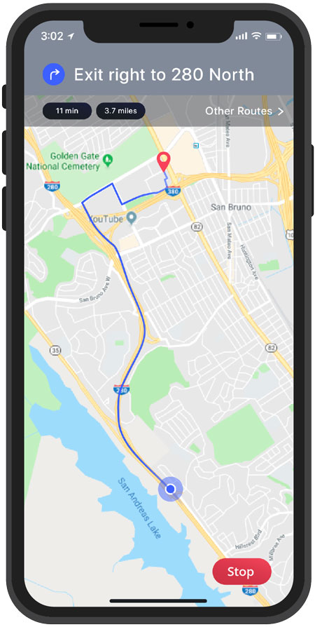

Take a moment to think about everything that we’ve come to expect from our experiences outdoors. Our base expectations include things like efficient, intelligent navigation to our destinations and real-time location information about those journeys using apps like Waze. We expect to be able to order food at any time of day or night, then watch it travel from the restaurant to our house on our phones using various delivery apps with asset tracking.
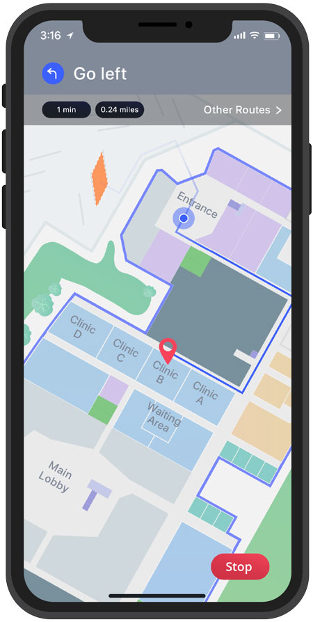
Indoor mapping is going to get away better in 2019
With that in mind, it’s hard to believe the discrepancy in our expectations and experiences between the outdoor world and the interiors of the buildings where we spend the vast majority of our time. Our experiences inside of buildings barely scratch the surface of delivering on the expectations we have for the outside world. Location-aware technologies have gradually, yet drastically, removed friction from our experiences when moving from building to building, but as soon as you enter a large, complex building, the friction increases like moving from a water slide to a patch of sandpaper.
This experience is beginning to change though. In 2019, we’ll increasingly see the at-scale removal of friction from the indoor world as more large and complex buildings begin to incorporate location-aware technologies. Existing buildings are gradually being retrofitted and digitized in order to deliver on the Internet of Things (IoT) use cases that businesses are seeking, and yet more new buildings are being constructed with location-aware technologies and digital indoor maps from the initial ground-breaking to improve job site safety.

Smart buildings are already here!
The rate at which buildings are becoming smarter varies dramatically depending on the industry you’re considering, and its own state of digital transformation and disruption. However, over the last few years I’ve seen industries such as healthcare, hospitality, retail, corporate campuses and transportation hubs take the first steps by implementing their use cases at proof of concept (POC) facilities. The key to implementing these IoT use cases that deliver significant business outcomes is having geospatially accurate digitized indoor maps. Organizations are now ready to move beyond their initial test sites and begin to digitize their indoor spaces enterprise-wide. For example, instead of the occasional hotel providing mobile indoor wayfinding apps, larger hoteliers will begin to roll out these solutions across thousands of facilities.
This will begin the process of fundamentally changing the way we live, work, and play indoors. The friction that we experience while journeying throughout indoor spaces will be increasingly removed from our daily lives, in the spaces where it matters.
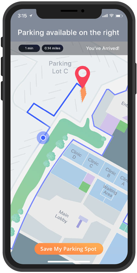
Healthcare delivery at hospitals will be more efficient, with queue management and a seamless mobile journey from our home to our appointments which we have booked and checked into using our phones. Travel will become a more enjoyable experience as transportation hubs reduce congestion, streamlining passenger flow and improving wayfinding experiences throughout their facilities. Our trips to the mall with be less stressful as our parking is recorded and we are navigated along the most efficient paths to our destinations, and back to our cars, then home, seamlessly. Corporate campuses will reallocate resources to occupied sections of offices, and HVAC systems will be integrated to decrease energy consumption.
As we move through 2019, indoor mapping will increasingly become part of the norm of our daily lives, and the digital experiences it affords will become expected. You won’t necessarily know when you’re in a building with digitized indoor maps, but you will certainly begin to notice when you’re not. Indoor maps are instrumental to reshaping our experience of place.