
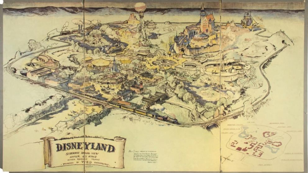
It was September 1953, and one of the greatest visionaries in American history was feverishly trying to turn his dream into a reality. Walt Disney knew if he wanted to secure the funds he required to build an amusement park, he would need to show his investors exactly what he planned to do with their money. So, he called up an artist friend, Herb Ryman, and spent the next 42 hours bringing to life on paper what we know as the happiest place on earth – Disneyland.
Now, this original, hand-drawn map and perhaps one of the most important artifacts in Disneyland’s history is headed to auction at California’s Van Eaton Galleries on June 25, according to ABC. It is expected to fetch somewhere between $750,000 and $1 million, making it one of the most valuable Disney memorabilia of all times.
Roughly 3×5 feet in size, the map is extremely fascinating for map collectors and Disney enthusiasts alike. It reveals little-known details about the park, like how Walt originally wanted to call Tomorrowland as World of Tomorrow. Or how an area called ‘Lilliputian Land’ from Gulliver’s Travels never took form.
The story behind how the map came to be preserved all these years is equally fascinating. In 1955, Disney employee Grenade Curran noticed the map lying neglected in the corner of Walt’s office and asked the filmmaker if he could take it home as a memento. Walt agreed, and Curran kept the map in safe custody hidden from the public eye for more than 60 years since.
Van Eaton Galleries co-owner Mike Van Eaton is calling the map the highlight of the upcoming auction, where almost 1,000 Disneyland artifacts are going under the hammer. “That an artifact like this, which is so deeply rooted in the creation of Disneyland, still exists today is astonishing,” he said in a statement.
Now read: Map of the Middle-Earth with Tolkien’s annotations found

#Featured

Next article


 With millions of drones already in operation in the European Union, the risk of a UAV colliding into a manned aircraft, damaging critical infrastructure, or invading a person’s privacy has become suddenly all too real. Understandably, the civil aviation agency is working to regulate the air space by laying down rules with regards to unmanned aircraft systems. Last week, the European Aviation Safety Agency (EASA) proposed rules that it hopes would address both safety concerns and privacy risks. These regulations would be applicable to drones that weigh more than 250 g but less than 150 kg.
Here’s what you need to know:
- The person operating a drone is responsible for the safe operation of that UAV and ensuring that no drone is flying too close to an emergency response service
- All people who are operating drones weighing more than 250 g need to register themselves as operators
- Any drone that weighs more than 900 g needs to be registered and fitted with geofencing technology so that it cannot enter prohibited areas
- Any drone equipped with an audio sensor or a camera of more than 5 MP and a real-time video transmission link must be remotely identifiable
- Manufacturers must include a leaflet in the UAV packaging detailing the rules of conduct and the main pointers of EU drone rules
- All drones must carry a label which defines the class it belongs to (C0 to C4), so an operator will immediately know the operational limitations it needs to comply with
- EU member states have the flexibility of designating airspace areas as special zones where the entry of UAVs may be prohibited or restricted
EASA has also explained how the proposed rules address the following issues:
Safety: Geofencing reduces the air risk when zones are created for the protection of aerodromes
Law enforcement: Registration and electronic identification allow taking action against a negligent or reckless operator
Security: Electronic identification and geofencing contribute to addressing the security risk through identification of potential threats or the designation of zones for the protection of sensitive installations
Privacy: Electronic identification contributes to the law enforcement of privacy rights and geofencing contributes to addressing the privacy risk through the creation of zones for the protection of the privacy of a community
This regulation shall enter into force on the day following that of its publication in the Official Journal of the European Union (estimate 2018). Currently, EASA is inviting comments and feedback from all stakeholders from May 12 to August 12, post which a final proposal will be submitted to the European Union by the end of 2017. To read the complete proposal document, click here.
Related: This great infographic shows the evolution of drones over the past decades