

Over the years I’ve seen plenty of great mappings projects and it doesn’t often happen that I get surprised by a geo-visualization method and this unexpected map totally made my day.
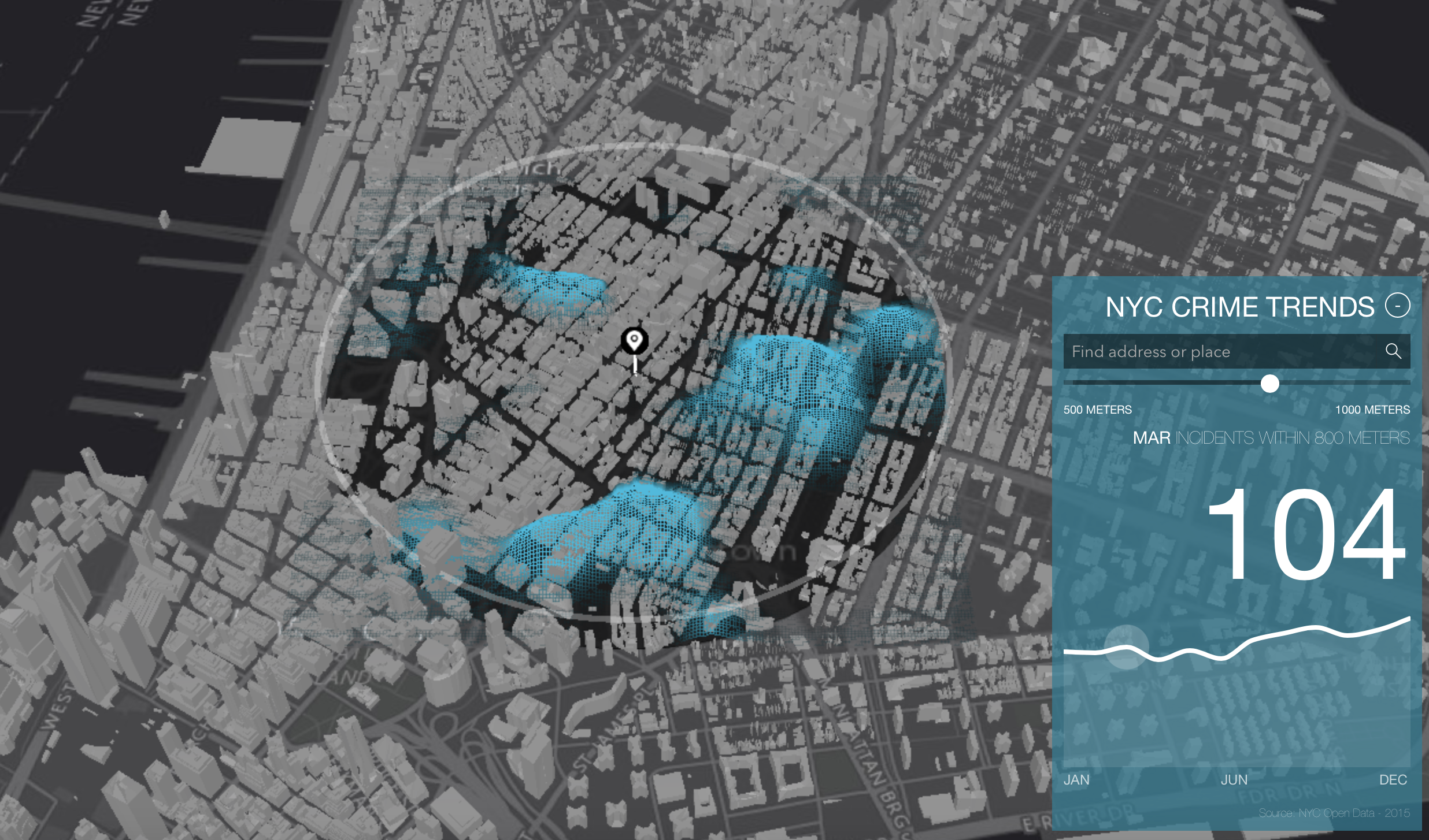
The map created as a part of Esri Cool Maps initiative shows NYC crime data in time. That sort of task could be done with a regular heatmap and a timeline, but instead, the heatmap is elevated on the top of the 3D buildings layer. User can click on any point of the map and preview month-by-month data in the range between 500-1000m around selected location. The effect is amazing.
The map is clearly just a showcase of the Esri’s platform capabilities rather than a value adding project to study crime data. You cannot control the playback speed or fast forward to the next month, the scope is limited, and there is no legend to really understand and interpret it. Even with all these limitations I totally love the design of this map and I wish to see more visualizations of that kind

#Ideas


Next article

![]()
Have you ever wondered the differences between the main GIS/Map providers? We have too. So we asked 6 of the largest providers 6 questions to help us better understand. We will be rolling out the answers we received in a series of blog posts. This is the first in the series and covers our first topic: core offering.
Please note, the answers provided in this blog series is text supplied of each of the providers. We have not altered the answers provided in any way. We will, in the last of the series, write a summary blog post.
Question 1: Can you summarize your core offering?
Pitney Bowes
Pitney Bowes’ Location Intelligence (LI) business breaks down into four segments within the broader LI market:
- Geographic information systems (GIS)
- Enterprise Location Intelligence, enabling technology through our APIs, and our global data products.
- MapInfo Pro is our core solution for desktop GIS mapping and analysis, a mature product that has undergone functional advancements and investment continuously for over 30 years.
- Spectrum Spatial technology is positioned to integrate with enterprise IT operations to provide location insights to the decision making process (e.g., insurance policy underwriting, customer on-boarding or consumer/citizen access to service information). It’s ease of integration with ERP, CRM, and business intelligence software offers users the ability to location-enable their enterprise computing applications.
Our APIs expose our underlying geospatial technology and data to software developers that want access to solutions such as geocoding and Pitney Bowes specialty data products. Lastly, Pitney Bowes has over 400 unique and global data products covering consumer intelligence and demographics, commerce and business, detailed administrative boundaries and geofences, and industry-specific products to help clients evaluate risk, predict sales, and understand market trends.
Carto
CARTO is Location Intelligence Software — it helps companies and governments analyze their spatial data to make all kinds of decisions. The platform is based on an open source geo-database and it combines customer-owned geo data with 3rd-party demographics and basemaps. Customers can develop custom apps on top of our analytics engine or let their users do self-service analysis with our front-end product (CARTO Builder).
Esri
1) The ArcGIS Platform
Many people think of ArcGIS is a professional desktop used to apply GIS to all kinds of projects. However, ArcGIS is much broader. It provides a comprehensive, wide-ranging GIS platform that connects Professional GIS Desktops to ArcGIS Enterprise and ArcGIS Online. These enable GIS throughout your enterprise, departments, and workgroups – as well as enabling a hosted cloud-based GIS via ArcGIS Online.
In this system of systems, Pro GIS seats can be extended with an on-premises, enterprise server, with cloud-based ArcGIS Online, or both. These support self-service mapping throughout an organization as well as providing numerous kinds of geographic analytic capabilities that include massive imagery and raster modeling, space-time and statistical analysis, big data management, and capabilities to handle real-time and sensor feeds (enabling the Internet-of-Things).
In addition, ArcGIS includes a wide range of apps to support everything – from taking ArcGIS into the field, for applying GIS by all kinds of users across your enterprise, for extending your GIS reach to all kinds of citizens and constituents, and for developers to provide custom apps.
Our partners and the developer community build many more solutions, and numerous other tech companies embed and interface ArcGIS to their technology, making ArcGIS one of the key emerging enterprise systems on the web and in the cloud.
2) The Living Atlas of the World
Every GIS is fueled by content coming from each organization as well as the broader geospatial community. The ArcGIS platform includes rich data – in fact, the most comprehensive geospatial database anywhere – called the Living Atlas of the World. It includes amazing base maps that scale from the entire world and into neighborhoods and sites, imagery and aerial photography, map layers of hundreds of demographic variables and boundaries, natural resources, and landscape layers, rich real-time and near-real time earth observations and forecasts – along with tens of thousands of open datasets.
These are delivered as online datasets, maps, apps, analytics, and workflows. They are curated from the best available content provided by the global ArcGIS user community, partners, and Esri. This represents millions of user contributions and billions of views each and every day. And this is growing rapidly in the cloud.
3) Powerful geospatial analytic capabilities
ArcGIS enables unprecedented and comprehensive analytic capabilities, including big data processing, massive image computing, spatial statistical modeling, space-time modeling, interactive spatial data exploration and visualization, and an extensive modeling language for data manipulation.
Boundless
Boundless offers an open source, commercially supported GIS ecosystem, comprised of a unique combination of technology, products and experts, that helps organizations unlock the business intelligence of their location-based data.
Key features include:
- The most comprehensive product line of commercially supported open GIS products including Desktop, Exchange and Suite.
- Boundless Connect, which delivers an ecosystem of geospatial tools, content and services to the community.
- Deep open source GIS expertise, including consulting, training and support.
Because the Boundless ecosystem is open source, there are no costly licensing fees associated with the technology, so there is no penalty to scale your platform up to meet need/demand. And most importantly, the Boundless ecosystem was built from the ground up to work in modern IT architectures.
GIS Cloud
GIS Cloud is a collaborative cloud mapping platform that includes web and mobile apps. With GIS Cloud, users can collect data in the field, create projects, visualize, analyze, share, export and publish spatial data through an intuitive interface. Although our core offering is focused on cloud-based mapping, we also offer on-premise (“firewall install”) enterprise solutions.
Also, GIS Cloud apps are built on top of an API, that also allows developing custom/vertical solutions for different industries.
GIS Cloud works through different web and mobile apps, that are connected to the GIS Cloud system and interface. Our core offering/complete SaaS solutions are:
- Map Editor – cloud based mapping app that supports uploading different spatial formats, visualization as well as a set of different GIS tools, analyses and symbology. It is a very simple yet powerful app for creating, editing, sharing, and updating and collaborating on maps and spatial data, used by both experts and users who are not GIS professionals.
- Mobile Data Collection – the mobile app for real-time field data collection. It enables creating custom forms with different fields (description, photos, audio-records, barcodes, number fields, radio buttons…). It enables updating and adding data to a layer on a map in real time, using simple forms that can easily be used on tablets and smartphones without additional training. It also allows collecting data in offline mode.
- Map Portal – solution for publishing spatial data on an interactive and customized, white-labeled map portal on a separate domain. It is especially useful for city portals, publishing cadastre and other data useful for citizens.
Also, GIS Cloud includes different extensions and integrations, such as Publisher for ArcMap.
Mapbox
Mapbox are a full stack geospatial provider. The Mapbox offering is built using open source software and data. The platform targets developers looking to integrate location into the apps they are building.