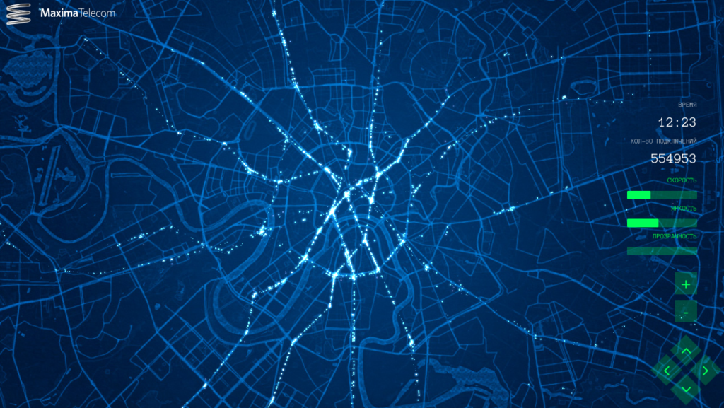

 Really interesting project coming from Russia. The Maxima Telecom – operator of WiFi services in Moscow metro has released a map that shows movement of passengers within their network, over the course of one day.
I really love the design. White dots representing clusters of passengers moving on the dark blue background map makes a really futuristic impression. It also makes us realise how much data this kind of services collected about people.
Sometime ago we have reported how mobile carriers are making money on selling our aggregated location information to 3rd party companies. Now we see that actually any kind of services that detect your smartphone identity can be used to track you. You don’t really have to be connected to a particular WiFi, it’s enough that WiFi on your smartphone is enabled.
On the other hand this kind of data is a dream of every transportation and urban planner. Precise origin destination matrix and commute paths allow to better analyse and understand the needs of citizens and optimise the public transit system.
Bottom line if the data are used for that kind of visualizations I could consider sharing my location data with the service provider.

#Ideas


Next article

Real-time maps, as an expression of spatio-temporal data are always interesting to explore and provide interesting insights into the system that is being visualized. The “Boston Bus Speed Map” for e.g. provides an amazing insight into how the public transit system works during rush hours in the city of Boston. TRAVIC on the other hand provides a global view of the public transit systems in different cities. But then how about real-time maps that showcase the movement of pedestrians and cyclists in a given area?
Real-time map of pedestrian traffic
Placemeter, a New-York based start-up has blogged about a real-time map of pedestrians (and bikers) outside Union Square, NYC. It’s probably the first time we are getting to see a real-time map of pedestrians and it’s really interesting to watch it in action!
Location-based Marketing
The map is an indicator of how location-based marketing might evolve in the future. Its entirely possible that such systems will be used to determine the rent of retail outlets (if online shopping doesn’t end up killing the concept by then, but I doubt that). Already in this map, its possible to get a real-time count of the number of people headed to Chipotle and Geox. It would be interesting to understand how companies can turn all this data into useful insight.
How did they map it? Privacy?
Placemeter utilises either its own sensors or Security camera feed (live or recorded) to extract information about the movement of pedestrians and vehicles outside a particular location. The startup has explicitly tried to allay privacy concerns about such a system by answering a few privacy related questions on their FAQs page.
Interested in more detailed analysis of how such location-based data can be put to use? Check out their analysis on “