
Aerial Remote Sensing to measure surface currents
Oceans have been the final frontier for Remote Sensing. Advances in airborne remote sensing systems have largely benefitted Land based data/information collection.
Over the years, there have been limitations in utilizing airborne remote sensing systems for oceanographic purposes. Remote sensing has helped build detailed elevation models for the land masses with much better accuracy when compared to sea surface models. The fact – it is still very difficult to build detailed sea surface models with airborne remote sensing is a good example of the gap that exists between airborne remote sensing and oceanographic applications.
Now, ROCIS is all set to bridge that gap (in a small way).
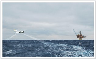
Remote Ocean Current Imaging System (ROCIS), a new airborne high resolution imaging system developed by Fugro and Areté Associates, bridges the gap between satellite observations and vessel based measurements using high resolution imaging to measure surface ocean currents over large areas. Source: FUGRO
The new ocean current measurement system uses high resolution aerial photography to capture surface waves and retrieves current data from the doppler shift of successive surface wave images. Data can be collected at altitudes between 900m to 3000 m. Two 11 megapixel digital cameras together with an inertial navigation system forms the core of the system.
But this technique has a limitation as it can only measure surface currents upto 5 meters in depth and not currents that are at greater depths. However the data in combination with in-situ measurements and other satellite imagery can offer a better understanding of offshore current behavior and help in development of predictive models.
As someone who has found GIS data hard to come by for oceanographic purposes, this new system is a promise for the future.
Furgo GEOS says offshore oil and gas operators are set to benefit from ROCIS, utilising the system’s accurate information to mitigate against the impact of ocean currents on exploration, development and production activities. Other applications of the airborne system include oil spill events, where the detailed, wide-area information can be used for response operations and for validation of oil spill models. Search and rescue operations could use current mapping and information of surface drift patterns to aid emergency responders.
Source: Offshore Shipping Online


#


Next article
The Ozone Monitoring Instrument on board NASA’s Aura Satellite is capable of tracking the pollution caused by ships in the seas. Satellite imagery released by NASA showing Nitrogen Dioxide (NO2) emission is definitely raising concerns. The extent of pollution is nothing unexpected but surely it is time to look for greener ways to take technology forward.
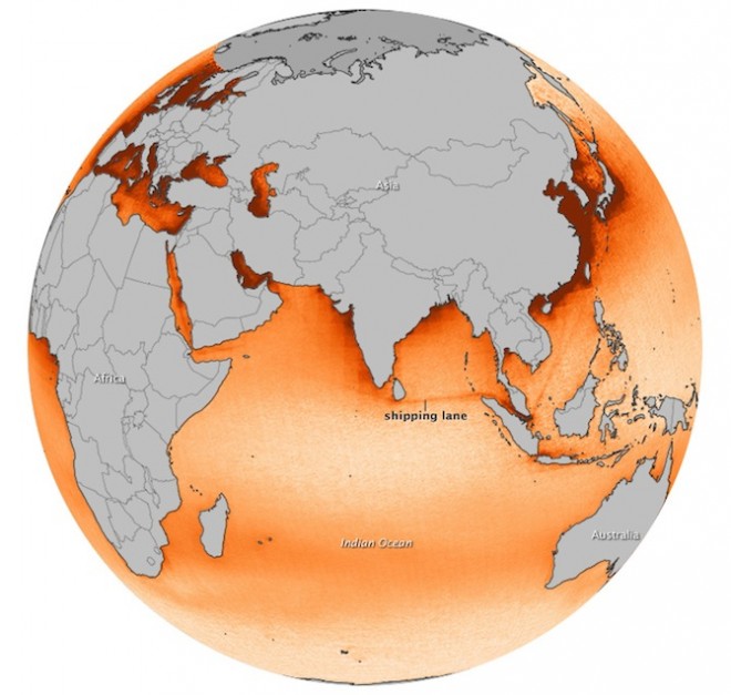
NASA’s Aura Satellite Imagery Showing tracks of pollution around the high seas
Interestingly, regions near to the coast look more polluted. But actually, the high seas are equally polluted but the current offer the possibility of dispersion where as near the coast, human activity only increases pollution.
There is tons of such imagery and analysis from NASA’s aura satellite. Here’s the link